Vietnam 3D Mobile Mapping Market (2026-2032) | Value, Challenges, Trends, Pricing Analysis, Opportunities, Size, Growth, Competition, Strategic Insights, Revenue, Competitive, Strategy, Segments, Consumer Insights, Outlook, Industry, Share, Restraints, Supply, Companies, Investment Trends, Forecast, Drivers, Analysis, Segmentation, Demand
Market Forecast By Component (Hardware, Software, Services), By Application (Road Surveys, Topographic Mapping, 3D Modeling, Asset Management, Others), By End User (Transportation & Logistics, Government & Public Sector, Energy & Utilities, Telecommunications, Others) And Competitive Landscape
| Product Code: ETC11536244 | Publication Date: Apr 2025 | Updated Date: Jun 2026 | Product Type: Market Research Report | |
| Publisher: 6Wresearch | Author: Bhawna Singh | No. of Pages: 70 | No. of Figures: 35 | No. of Tables: 5 |
Vietnam 3D Mobile Mapping Market Growth Rate
According to 6Wresearch internal database and industry insights, the Vietnam 3D Mobile Mapping Market is projected to grow at a compound annual growth rate (CAGR) of 15.4% during the forecast period (2026–2032).
Vietnam 3D Mobile Mapping Market Year-wise Growth Rate and Key Drivers
This graph highlights how the Vietnam 3D Mobile Mapping Market has steadily grown over the past five years, supported by major growth factors.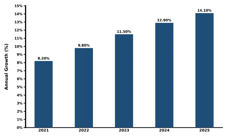
Below is an evaluation of year-wise growth rate along with growth drivers:
| Year | Est. Annual Growth (%) | Growth Drivers |
| 2021 | 8.2% | Adoption of vehicle-mounted data collectors for urban transport asset assessment and roadway charting. |
| 2022 | 9.8% | Balancing accelerated smart city investments in key urban centers and the need for structural network monitoring. |
| 2023 | 11.5% | Better alignment of LiDAR sensors with GIS systems of local economic zones. |
| 2024 | 12.9% | Nationwide deployment of fast 5G services coupled with increasing interest in real-time location tracking apps. |
| 2025 | 14.1% | Foreign direct investment in logistics technologies and increased automation of transportation routes. |
Topics Covered in the Vietnam 3D Mobile Mapping Market Report
The Vietnam 3D Mobile Mapping Industry report covers the market by component, application, and end user. The market report provides an unbiased and detailed analysis of ongoing market trends, opportunities, and drivers, which help stakeholders devise and align their market strategies according to the current and future market dynamics.
Vietnam 3D Mobile Mapping Market Highlights
| Report Name | Vietnam 3D Mobile Mapping Market |
| Forecast period | 2026-2032 |
| CAGR | 15.4% |
| Growing Sector | Media & Telecommunications |
Vietnam 3D Mobile Mapping Market Synopsis
Vietnam 3D Mobile Mapping Market is emerging as a vital component of the country’s geospatial and smart infrastructure development ecosystem. 3D mobile mapping refers to advanced surveying technology that captures detailed geospatial data while moving through an environment using integrated systems such as LiDAR sensors, high-resolution cameras, GNSS (Global Navigation Satellite Systems), and inertial measurement units (IMUs).
The marketplace is fueled by the rising need for precise and timely spatial information that will be utilized in urban planning, traffic management, construction, and asset tracking. With Vietnam increasingly investing in smart cities, highways, railway, and industrial districts, the requirement for effective mapping technologies will only continue to rise.
Evaluation of Growth Drivers in Vietnam 3D Mobile Mapping Market (2026–2032)
Below are some major drivers and their influence on the market dynamics:
| Drivers | Primary Segment Affected | Why It Matters (Evidence) |
| Government Initiatives | Road Surveys, Asset Management | Official national decrees mandating the use of digital geospatial verification to manage public transport corridors are fueling system updates. |
| Smart City Master Plans | 3D Modeling, Topographic Mapping | Master development programs across Hanoi and Ho Chi Minh City require extensive digital-twin urban models to manage resources. |
| Telecom Infrastructure Upgrades | Hardware, Services | The nationwide operational activation of commercial 5G architecture allows massive point-cloud packets to stream instantly to servers. |
| E-Commerce and Logistics Scaling | Asset Management, Road Surveys | Rapid structural growth in last-mile parcel networks demands highly detailed street-level navigation mapping to maximize vehicle routes. |
| UAV and Sensor Cost Reductions | Hardware, Software | Decreasing global costs for localized laser scanning components and vehicle-mounted cameras allow service firms to buy equipment easier. |
The Vietnam 3D Mobile Mapping Market is expected to witness enormous expansion, growing at a CAGR of 15.4% during the forecast period (2026-2032). This growth is supported by the rising integration of advanced technologies such as LiDAR, AI-based spatial analytics, and cloud-based GIS platforms, which are significantly improving the speed, accuracy, and usability of mapping data.
In addition, Vietnam’s expanding industrial corridors and urban redevelopment programs are creating consistent demand for mobile mapping systems to support road network optimization, utility mapping, and asset tracking. As a result, the Vietnam 3D mobile mapping market growth is expected to maintain strong momentum throughout the forecast period, becoming a key enabler of country’s digital transformation and smart city development goals.
Evaluation of Restraints in Vietnam 3D Mobile Mapping Market
Below are some major restraints and their influence on the market dynamics:
| Restraints | Primary Segment Affected | What This Means (Evidence) |
| High Initial Capital Outlay | Hardware, Capital Allocation | The elevated procurement costs for high-grade industrial mobile LiDAR units, GNSS receivers, and IMU tracking modules limit mid-tier engineering companies. |
| Data Privacy & Security Norms | Government & Public Sector, Services | Strict state guidelines regarding the gathering, storage, and processing of high-accuracy defense-zone spatial coordinates delay workflow approvals. |
| Shortage of Skilled Specialists | Software, Services | A limited local pool of specialized point-cloud processing technicians and computational mapping specialists hinders immediate market expansion. |
| Environmental Deterrents to Data Collection | Weather & Environment | Heavy rains due to strong monsoons, coupled with high humidity levels, frequently cause disruptions for data collection in critical terrain corridors. |
| Limited GPS Signal Availability in Remote Belts | Equipment & Logistical Issues | Limited availability of GNSS signals in the outer mountain ranges results in poor tracking capability with no alternate set-up. |
Vietnam 3D Mobile Mapping Market Challenges
Vietnam 3D Mobile Mapping Industry is facing technical challenges related to data management and urban clutter. Gathering high-density 3D spatial points from vehicle-mounted sensors across crowded metropolitan centers generates massive terabytes of unstructured raw data, overloading local cloud-storage architectures. Additionally, the extreme density of motorcycles and chaotic roadside commercial structures in urban zones creates extensive laser occlusion zones, demanding prolonged manual data cleaning and complex software corrections.
Vietnam 3D Mobile Mapping Industry Trends
Key trends reshaping the Vietnam 3D Mobile Mapping Market are:
- Integration with Augmented Reality (AR): Visual mobile application platforms are integrating live 3D mobile mapping data structures to provide real-time AR navigation overlays for consumer commercial applications.
- Transition into AI-Driven Feature Extraction: Spatial processing labs are deploying deep learning vision models to automatically detect and classify road signs, light poles, and pavement cracking directly from collected data.
- Expansion of Drone-Assisted Hybrid Systems: Mapping operators are combining vehicular mobile platforms with synchronized unmanned aerial vehicles (UAVs) to gather complete 3D data across complex vertical structures.
Investment Opportunities in the Vietnam 3D Mobile Mapping Market
Some strategic investment opportunities are mentioned below:
- Digital Twin Development Projects: Mobile mapping is a core enabler of digital twin technology. The investors may concentrate on creating virtual maps of various urban areas, industrial areas, and infrastructural assets.
- Government Surveying and National Mapping Projects: Governmental programs for land surveying, cadastral surveys, and infrastructural surveillance projects provide stable and long-term investments through PPP.
- Drone-Mobile Hybrid Mapping Systems: The combination of drones and mobile mapping systems ensures accurate mapping data. Geospatial solutions involving drones have become popular in Vietnam’s difficult-to-map geography.
- Telecommunications Network Planning and Optimization: Mobile mapping is increasingly used for telecom tower placement, 5G network planning, and fiber-optic route optimization, creating opportunities in telecom infrastructure analytics.
Top 5 Leading Players in Vietnam 3D Mobile Mapping Market
Below are some of the leading companies operating in the Vietnam 3D Mobile Mapping Market:
1. Vietmap Company Limited
| Company Name | Vietmap Company Limited |
|---|---|
| Established Year | 2006 |
| Headquarters | Ho Chi Minh City, Vietnam |
| Website | Click Here |
Vietmap deploys advanced vehicle-tracking sensor fleets and mobile data systems, providing highly detailed digital mapping layers, and high-precision route management databases for commercial enterprises nationwide.
2. Portcoast Consultant Joint Stock Company
| Company Name | Portcoast Consultant Joint Stock Company |
|---|---|
| Established Year | 2004 |
| Headquarters | Ho Chi Minh City, Vietnam |
| Website | Click Here |
Portcoast has transformed into a high-tech powerhouse by investing heavily in advanced mobile mapping systems, vehicle-mounted laser scanners, and drone-based tracking solutions.
3. VidaGIS Company Limited
| Company Name | VidaGIS Company Limited |
|---|---|
| Established Year | 2004 |
| Headquarters | Hanoi, Vietnam |
| Website | Click Here |
Working as a specialized technology venture with international alignment, VidaGIS focuses on spatial application architecture, complex database creation, and mobile asset mapping.
4. VMT Solutions Co., Ltd.
| Company Name | VMT Solutions Co., Ltd. |
|---|---|
| Established Year | 2009 |
| Headquarters | Ho Chi Minh City, Vietnam |
| Website | - |
VMT Solutions transforms large mobile mapping point-cloud inputs into highly structured 3D BIM frameworks and accurate CAD infrastructure representations.
5. Geolink Vietnam
| Company Name | Geolink Vietnam |
|---|---|
| Established Year | 2015 |
| Headquarters | Hanoi, Vietnam |
| Website | - |
Geolink Vietnam distributes advanced mobile mapping hardware setups, vehicle tracking arrays, and cloud-based GIS platform solutions, servicing regional railway layout teams, and smart city infrastructure divisions.
Government Initiatives being implemented in the Vietnam 3D Mobile Mapping Market
Government initiatives within the 3D mobile mapping market in Vietnam are now more in sync with the digital transformation and infrastructure development objectives of the country. This includes the development and execution of the National Digital Transformation Program (2025-2030 vision) that involves the use of geospatial technology, geographic information system (GIS) platforms, and digital surveying in the efficient management of the country.
Along with this, smart city development strategy in Vietnam is gaining momentum and being implemented in major urban cities like Hanoi, Ho Chi Minh City, and Da Nang. The deployment of mapping technologies within the transportation management, land planning, and infrastructure monitoring processes are underway. At the same time, the development of expressways and metros also requires the application of digital mapping systems.
Source: https://www.trade.gov/country-commercial-guides/vietnam-digital-economy
Future Insights of the Vietnam 3D Mobile Mapping Market
Vietnam 3D Mobile Mapping Market is likely to develop into a key driver of intelligent infrastructure and digital twins during the forecast period. The growing need for geospatial intelligence will bring new ways of thinking about city planning, transport networks, and utility management. The convergence of AI, cloud computing, and advanced analytics with mobile mapping tools will enable increased precision and efficiency in spatial information gathering, facilitating predictive planning and automated infrastructure monitoring.
During the next few years, it will become necessary to focus more on continuous mapping rather than surveys to update the constantly evolving urban environments. This will be especially useful for extending smart cities, creating infrastructure for self-driving vehicles, and building industries on a large scale. As Vietnam becomes increasingly involved in developing its digital economy and infrastructure, the 3D mobile mapping market can play an important role in achieving this goal.
Market Segmentation Analysis
The report offers a comprehensive study of the following market segments and their leading categories:
By Application – Road Surveys to Lead the Market
According to Rahul, Senior Research Analyst, 6Wresearch, Road surveys constitute the fastest-growing and largest application segment in the Vietnam 3D Mobile Mapping Market. Driven by massive national highway construction plans, urban street remodeling programs, and rural development corridors across Vietnam, transportation agencies use vehicle-mounted mapping arrays to quickly catalog thousands of road miles with minimal traffic disruption.
By End User – Transportation & Logistics to Lead the Market
The transportation and logistics industry commands the leading Vietnam 3D mobile mapping market share, driven by the massive scaling of localized distribution hubs, container freight tracking centers, and digital supply chain corridors, private logistics operators are utilizing detailed 3D spatial data layers to automate fleet movements, design efficient routes, and manage physical assets.
Key Attractiveness of the Report:
- 10 Years of Market Numbers
- Historical Data Starting from 2022 to 2025
- Base Year: 2025
- Forecast Data until 2032
- Key Performance Indicators Impacting the Market
- Major Upcoming Developments and Projects
Key Highlights of the Report:
- Vietnam 3D Mobile Mapping Market Outlook
- Market Size of Vietnam 3D Mobile Mapping Market, 2025
- Forecast of Vietnam 3D Mobile Mapping Market, 2032
- Historical Data and Forecast of Vietnam 3D Mobile Mapping Revenues & Volume for the Period 2022-2032
- Vietnam 3D Mobile Mapping Market Trend Evolution
- Vietnam 3D Mobile Mapping Market Drivers and Challenges
- Vietnam 3D Mobile Mapping Price Trends
- Vietnam 3D Mobile Mapping Porter's Five Forces
- Vietnam 3D Mobile Mapping Industry Life Cycle
- Historical Data and Forecast of Vietnam 3D Mobile Mapping Market Revenues & Volume By Component for the Period 2022-2032
- Historical Data and Forecast of Vietnam 3D Mobile Mapping Market Revenues & Volume By Hardware for the Period 2022-2032
- Historical Data and Forecast of Vietnam 3D Mobile Mapping Market Revenues & Volume By Software for the Period 2022-2032
- Historical Data and Forecast of Vietnam 3D Mobile Mapping Market Revenues & Volume By Services for the Period 2022-2032
- Historical Data and Forecast of Vietnam 3D Mobile Mapping Market Revenues & Volume By Application for the Period 2022-2032
- Historical Data and Forecast of Vietnam 3D Mobile Mapping Market Revenues & Volume By Road Surveys for the Period 2022-2032
- Historical Data and Forecast of Vietnam 3D Mobile Mapping Market Revenues & Volume By Topographic Mapping for the Period 2022-2032
- Historical Data and Forecast of Vietnam 3D Mobile Mapping Market Revenues & Volume By 3D Modeling for the Period 2022-2032
- Historical Data and Forecast of Vietnam 3D Mobile Mapping Market Revenues & Volume By Asset Management for the Period 2022-2032
- Historical Data and Forecast of Vietnam 3D Mobile Mapping Market Revenues & Volume By Others for the Period 2022-2032
- Historical Data and Forecast of Vietnam 3D Mobile Mapping Market Revenues & Volume By End User for the Period 2022-2032
- Historical Data and Forecast of Vietnam 3D Mobile Mapping Market Revenues & Volume By Transportation & Logistics for the Period 2022-2032
- Historical Data and Forecast of Vietnam 3D Mobile Mapping Market Revenues & Volume By Government & Public Sector for the Period 2022-2032
- Historical Data and Forecast of Vietnam 3D Mobile Mapping Market Revenues & Volume By Energy & Utilities for the Period 2022-2032
- Historical Data and Forecast of Vietnam 3D Mobile Mapping Market Revenues & Volume By Telecommunications for the Period 2022-2032
- Historical Data and Forecast of Vietnam 3D Mobile Mapping Market Revenues & Volume By Others for the Period 2022-2032
- Vietnam 3D Mobile Mapping Import Export Trade Statistics
- Market Opportunity Assessment By Component
- Market Opportunity Assessment By Application
- Market Opportunity Assessment By End User
- Vietnam 3D Mobile Mapping Top Companies Market Share
- Vietnam 3D Mobile Mapping Competitive Benchmarking By Technical and Operational Parameters
- Vietnam 3D Mobile Mapping Company Profiles
- Vietnam 3D Mobile Mapping Key Strategic Recommendations
Market Covered
The report offers an extensive study of the following market segments:
By Component
- Hardware
- Software
- Services
By Application
- Road Surveys
- Topographic Mapping
- 3D Modeling
- Asset Management
- Others
By End User
- Transportation & Logistics
- Government & Public Sector
- Energy & Utilities
- Telecommunications
- Others
Vietnam 3D Mobile Mapping Market (2026-2032): FAQs
Vietnam 3D Mobile Mapping Market is anticipated to grow at a compound annual growth rate (CAGR) of 15.4% during the forecast period (2026-2032).
Vietnam 3D Mobile Mapping Market is driven by smart city development, infrastructure expansion, and increasing adoption of GIS and LiDAR-based mapping technologies.
The transportation and logistics sector dominates due to large-scale highway, metro, and urban road development projects.
High equipment costs, shortage of skilled GIS professionals, and reliance on imported hardware are key challenges.
6Wresearch actively monitors the Vietnam 3D Mobile Mapping Market and publishes its comprehensive annual report, highlighting emerging trends, growth drivers, revenue analysis, and forecast outlook. Our insights help businesses to make data-backed strategic decisions with ongoing market dynamics. Our analysts track relevent industries related to the Vietnam 3D Mobile Mapping Market, allowing our clients with actionable intelligence and reliable forecasts tailored to emerging regional needs.
Yes, we provide customisation as per your requirements. To learn more, feel free to contact us on sales@6wresearch.com
| 1 Executive Summary |
| 2 Introduction |
| 2.1 Key Highlights of the Report |
| 2.2 Report Description |
| 2.3 Market Scope & Segmentation |
| 2.4 Research Methodology |
| 2.5 Assumptions |
| 3 Vietnam 3D Mobile Mapping Market Overview |
| 3.1 Vietnam Country Macro Economic Indicators |
| 3.2 Vietnam 3D Mobile Mapping Market Revenues & Volume, 2022 & 2032F |
| 3.3 Vietnam 3D Mobile Mapping Market - Industry Life Cycle |
| 3.4 Vietnam 3D Mobile Mapping Market - Porter's Five Forces |
| 3.5 Vietnam 3D Mobile Mapping Market Revenues & Volume Share, By Component, 2022 & 2032F |
| 3.6 Vietnam 3D Mobile Mapping Market Revenues & Volume Share, By Application, 2022 & 2032F |
| 3.7 Vietnam 3D Mobile Mapping Market Revenues & Volume Share, By End User, 2022 & 2032F |
| 4 Vietnam 3D Mobile Mapping Market Dynamics |
| 4.1 Impact Analysis |
| 4.2 Market Drivers |
| 4.2.1 Increasing demand for accurate and detailed mapping solutions for urban planning and infrastructure development |
| 4.2.2 Growing adoption of 3D mapping technology in sectors such as construction, transportation, and real estate |
| 4.2.3 Government initiatives and investments in digital mapping technologies to support smart city development |
| 4.3 Market Restraints |
| 4.3.1 High initial investment and operational costs associated with implementing 3D mobile mapping solutions |
| 4.3.2 Limited expertise and skilled professionals in the field of 3D mapping technology |
| 4.3.3 Data privacy and security concerns related to the collection and storage of large volumes of mapping data |
| 5 Vietnam 3D Mobile Mapping Market Trends |
| 6 Vietnam 3D Mobile Mapping Market, By Types |
| 6.1 Vietnam 3D Mobile Mapping Market, By Component |
| 6.1.1 Overview and Analysis |
| 6.1.2 Vietnam 3D Mobile Mapping Market Revenues & Volume, By Component, 2022 - 2032F |
| 6.1.3 Vietnam 3D Mobile Mapping Market Revenues & Volume, By Hardware, 2022 - 2032F |
| 6.1.4 Vietnam 3D Mobile Mapping Market Revenues & Volume, By Software, 2022 - 2032F |
| 6.1.5 Vietnam 3D Mobile Mapping Market Revenues & Volume, By Services, 2022 - 2032F |
| 6.2 Vietnam 3D Mobile Mapping Market, By Application |
| 6.2.1 Overview and Analysis |
| 6.2.2 Vietnam 3D Mobile Mapping Market Revenues & Volume, By Road Surveys, 2022 - 2032F |
| 6.2.3 Vietnam 3D Mobile Mapping Market Revenues & Volume, By Topographic Mapping, 2022 - 2032F |
| 6.2.4 Vietnam 3D Mobile Mapping Market Revenues & Volume, By 3D Modeling, 2022 - 2032F |
| 6.2.5 Vietnam 3D Mobile Mapping Market Revenues & Volume, By Asset Management, 2022 - 2032F |
| 6.2.6 Vietnam 3D Mobile Mapping Market Revenues & Volume, By Others, 2022 - 2032F |
| 6.3 Vietnam 3D Mobile Mapping Market, By End User |
| 6.3.1 Overview and Analysis |
| 6.3.2 Vietnam 3D Mobile Mapping Market Revenues & Volume, By Transportation & Logistics, 2022 - 2032F |
| 6.3.3 Vietnam 3D Mobile Mapping Market Revenues & Volume, By Government & Public Sector, 2022 - 2032F |
| 6.3.4 Vietnam 3D Mobile Mapping Market Revenues & Volume, By Energy & Utilities, 2022 - 2032F |
| 6.3.5 Vietnam 3D Mobile Mapping Market Revenues & Volume, By Telecommunications, 2022 - 2032F |
| 6.3.6 Vietnam 3D Mobile Mapping Market Revenues & Volume, By Others, 2022 - 2032F |
| 7 Vietnam 3D Mobile Mapping Market Import-Export Trade Statistics |
| 7.1 Vietnam 3D Mobile Mapping Market Export to Major Countries |
| 7.2 Vietnam 3D Mobile Mapping Market Imports from Major Countries |
| 8 Vietnam 3D Mobile Mapping Market Key Performance Indicators |
| 8.1 Average daily active users (DAU) of 3D mobile mapping applications |
| 8.2 Percentage increase in the number of infrastructure projects using 3D mapping technology |
| 8.3 Rate of adoption of 3D mapping solutions by government agencies and private sector companies |
| 9 Vietnam 3D Mobile Mapping Market - Opportunity Assessment |
| 9.1 Vietnam 3D Mobile Mapping Market Opportunity Assessment, By Component, 2022 & 2032F |
| 9.2 Vietnam 3D Mobile Mapping Market Opportunity Assessment, By Application, 2022 & 2032F |
| 9.3 Vietnam 3D Mobile Mapping Market Opportunity Assessment, By End User, 2022 & 2032F |
| 10 Vietnam 3D Mobile Mapping Market - Competitive Landscape |
| 10.1 Vietnam 3D Mobile Mapping Market Revenue Share, By Companies, 2025 |
| 10.2 Vietnam 3D Mobile Mapping Market Competitive Benchmarking, By Operating and Technical Parameters |
| 11 Company Profiles |
| 12 Recommendations |
| 13 Disclaimer |
Global Go To Market Strategy - 2030
Export potential enables firms to identify high-growth global markets with greater confidence by combining advanced trade intelligence with a structured quantitative methodology. The framework analyzes emerging demand trends and country-level import patterns while integrating macroeconomic and trade datasets such as GDP and population forecasts, bilateral import–export flows, tariff structures, elasticity differentials between developed and developing economies, geographic distance, and import demand projections. Using weighted trade values from 2020–2024 as the base period to project country-to-country export potential for 2030, these inputs are operationalized through calculated drivers such as gravity model parameters, tariff impact factors, and projected GDP per-capita growth. Through an analysis of hidden potentials, demand hotspots, and market conditions that are most favorable to success, this method enables firms to focus on target countries, maximize returns, and global expansion with data, backed by accuracy.
By factoring in the projected importer demand gap that is currently unmet and could be potential opportunity, it identifies the potential for the Exporter (Country) among 190 countries, against the general trade analysis, which identifies the biggest importer or exporter.
To discover high-growth global markets and optimize your business strategy:
Click Here
Pricing
- Single User License$ 1,995
- Department License$ 2,400
- Site License$ 3,120
- Global License$ 3,795

Leadership Perspectives from Industry Events
Search
Thought Leadership and Analyst Meet


Our Clients
6WResearch In News
- Doha a strategic location for EV manufacturing hub: IPA Qatar
- Demand for luxury TVs surging in the GCC, says Samsung
- Empowering Growth: The Thriving Journey of Bangladesh’s Cable Industry
- Demand for luxury TVs surging in the GCC, says Samsung
- Video call with a traditional healer? Once unthinkable, it’s now common in South Africa
- Intelligent Buildings To Smooth GCC’s Path To Net Zero
Latest Reports
- Taiwan Airport Wireless Infrastructure Market (2026-2032)
- Vietnam Airport Wireless Infrastructure Market (2026-2032)
- Thailand Airport Wireless Infrastructure Market (2026-2032)
- South Korea Airport Wireless Infrastructure Market (2026-2032)
- Romania Airport Wireless Infrastructure Market (2026-2032)
- Qatar Airport Wireless Infrastructure Market (2026-2032)
- Philippines Airport Wireless Infrastructure Market (2026-2032)
- Japan Airport Wireless Infrastructure Market (2026-2032)
- Taiwan Airport Winter Services Market (2026-2032)
- Vietnam Airport Winter Services Market (2026-2032)
Industry Events and Analyst Meet

HIMTEX 2026

India Refining Summit 2026

India EV Show 2026

EV tech India Expo 2026

Auto Tech Asia 2026
Whitepaper
- Middle East & Africa Commercial Security Market Click here to view more.
- Middle East & Africa Fire Safety Systems & Equipment Market Click here to view more.
- GCC Drone Market Click here to view more.
- Middle East Lighting Fixture Market Click here to view more.
- GCC Physical & Perimeter Security Market Click here to view more.