India Smart City Imaging Market Size & Growth Rate
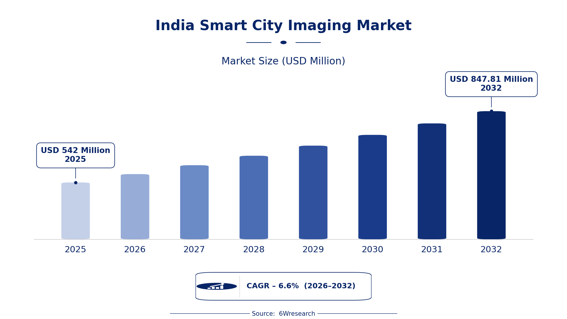
According to 6Wresearch internal database and industry insights, the India Smart City Imaging Market was valued at USD 542.0 million in 2025 and is projected to reach USD 847.81 million by 2032, growing at a CAGR of approximately 6.6% during 2026–2032.
India Smart City Imaging Market Highlights
| Report Metric | Details |
| Report Name | India Smart City Imaging Market |
| Market Size 2025 | USD 542.0 million |
| Market Size 2032 | USD 847.81 million |
| Absolute Growth 2025–2032 | USD 305.81 million |
| CAGR 2026–2032 | 6.6% |
| Peak Annual Growth | 8.4% in 2027 |
| Forecast Period | 2026–2032 |
| Historical Data | 2022–2025 |
| Base Year | 2025 |
| Leading Imaging Type, 2025 | CCTV Imaging (39% share) |
| Leading Use Case, 2025 | City-Wide Planning (40% share) |
| Leading Technology Used, 2025 | Remote Sensing (29% share) |
| Leading End User, 2025 | Urban Development Boards (47% share) |
| Fastest-Growing Imaging Type | Drone Imaging (8.5% CAGR) |
| Fastest-Growing Use Case | Traffic & Utilities (8.6% CAGR) |
| Fastest-Growing Technology Used | UAV + Photogrammetry (8.9% CAGR) |
| Fastest-Growing End User | Infrastructure Agencies (9.4% CAGR) |
| Growing Sector | Urban Development |
| Key End Users | Urban Development Boards, Police/Municipalities, Infrastructure Agencies, GIS/Mapping Firms |
India Smart City Imaging Market Year-wise Growth Rate and Key Drivers (2022–2032)
This graph illustrates the annual growth rates of the market from 2022 to 2032, highlighting a steady upward trajectory and projected market expansion over the forecast period.
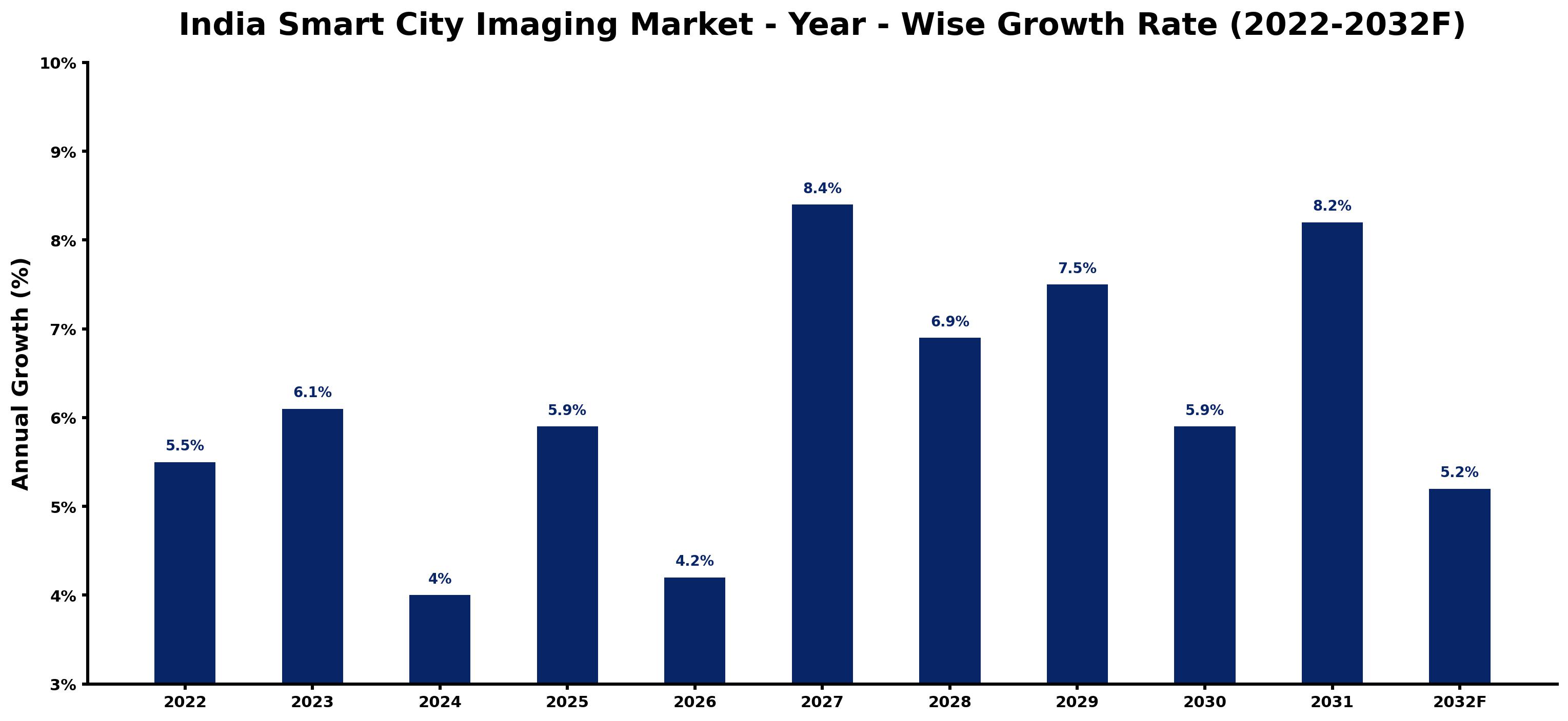
Below, each year's estimated growth is shown next to the factor that most influenced it.
| Year | Estimated Annual Growth (%) | Market Rationale |
| 2022 | 5.5 | The market experienced steady growth due to the Smart Cities Mission promoting urban development. |
| 2023 | 6.1 | Increased funding from the government for smart city projects accelerated market expansion. |
| 2024 | 4.0 | Growth slowed as project implementations faced delays in urban planning approvals. |
| 2025 | 5.9 | Demand rose again with new smart city initiatives launched across various states. |
| 2026 | 4.2 | A slowdown occurred as urban development boards reassessed project priorities. |
| 2027 | 8.4 | The market surged with peak growth driven by the adoption of advanced imaging technologies. |
| 2028 | 6.9 | Growth decelerated as some projects entered the final stages of completion. |
| 2029 | 7.5 | Demand increased again as urban infrastructure projects gained momentum. |
| 2030 | 5.9 | Growth slowed as urban development boards focused on project evaluations. |
| 2031 | 8.2 | The market saw a rise as technology integration in urban planning advanced. |
| 2032 | 5.2 | Growth decelerated as the Smart Cities Mission reached a more mature phase. |
Note: Market size estimations and growth projections presented in this report are based on 6Wresearch's proprietary forecasting methodology, utilizing the latest available industry data, government publications, and primary research inputs.
India Smart City Imaging Market Synopsis
Smart City Imaging in India includes technologies such as satellite, drone, and CCTV imaging for urban planning and management. These technologies improve traffic monitoring and infrastructure management. The India Smart City Imaging Market is expanding due to substantial government investments and initiatives, particularly the Smart Cities Mission, which aims to develop 100 smart cities with an allocation of ₹48,000 crores. Key buyers include Urban Development Boards and municipalities, which are driving demand for advanced imaging technologies.
Market Dynamics Impact Analysis (2026–2032)
| Factor | Type | Impact | Primary Segment Affected |
| Increased funding for urban infrastructure projects | Driver | High | City-Wide Planning |
| Growing adoption of AI technologies in urban management | Driver | High | Remote Sensing |
| Rising demand for detailed urban mapping solutions | Opportunity | High | Aerial Mapping |
| Need for enhanced surveillance systems in urban areas | Opportunity | Medium | CCTV Imaging |
| Delays in project approvals from urban development boards | Restraint | High | Traffic & Utilities |
| Challenges in integrating new technologies with existing systems | Restraint | Medium | Drone Imaging |
| Limited skilled workforce for advanced imaging technologies | Challenge | High | Infrastructure Agencies |
| High costs associated with implementing smart city solutions | Challenge | Medium | Urban Development Boards |
Evaluation of Drivers in India Smart City Imaging Market (2026–2032)
The main growth drivers and the segments they affect most are set out below.
| Drivers | Primary Segment Affected | Why It Matters (Evidence) |
| Government funding for smart city initiatives | CCTV Imaging | The Indian government allocated ₹48,000 crores for smart city projects, increasing demand for surveillance technologies. |
| Integration of AI in urban management systems | Remote Sensing | AI technologies are increasingly integrated into urban management, improving data analysis capabilities. |
| Expansion of urban infrastructure projects | City-Wide Planning | Over 1,000 projects initiated under the Smart City Mission drive demand for urban planning solutions. |
| Growing emphasis on public safety | Surveillance | CCTV installations in urban areas increased by 30% in the last two years, reflecting a heightened focus on security. |
| Adoption of advanced mapping technologies | Aerial Mapping | LiDAR technology is being adopted for detailed topographical mapping, improving urban planning accuracy. |
Over 1,000 projects initiated under the Smart City Mission drive the need for urban planning solutions. CCTV installations increased by 30% in urban areas, reflecting a focus on public safety. The adoption of LiDAR technology is improving mapping accuracy, further supporting growth in this market.
Evaluation of Restraints in India Smart City Imaging Market
The table below lists the restraints and the evidence behind each.
| Market Restraint | Primary Segment Affected | Why It Matters (Evidence) |
| Delays in project approvals from urban development boards | Traffic & Utilities | Approval delays hinder timely implementation, affecting project timelines and costs for municipalities. |
| Challenges in integrating new technologies with existing systems | Drone Imaging | Integration issues can lead to increased costs and delays in deploying smart city solutions. |
| Limited skilled workforce for advanced imaging technologies | Infrastructure Agencies | A shortage of skilled professionals can slow down project execution and increase operational costs. |
| High costs associated with implementing smart city solutions | Urban Development Boards | Budget constraints can limit the scope and scale of smart city projects, affecting overall growth. |
| Regulatory hurdles in technology adoption | CCTV Imaging | Compliance with standards can delay the deployment of surveillance systems in urban areas. |
India Smart City Imaging Market Challenges
Municipalities in the India Smart City Imaging market face regulatory complexities, as the Bureau of Indian Standards has established intricate guidelines that prolong project approvals, causing delays of up to six months. Suppliers encounter fierce competition, leading to aggressive pricing strategies that can shrink profit margins by as much as 20%, limiting their ability to invest in new imaging technologies. Rapid technological changes create challenges for suppliers who struggle to adapt, risking obsolescence and limiting their market presence. Supply chain disruptions, particularly in sourcing advanced imaging equipment, can postpone project timelines and affect urban development authorities' progress towards the Smart City Mission goals.
Trends in the India Smart City Imaging Market
Buyers and suppliers in the India Smart City Imaging Market are adjusting to the following trends.
- Shift from Traditional to Smart Surveillance Systems: Delhi has experienced a shift towards smart surveillance systems, with CCTV installations increasing by 30% recently. This trend improves public safety and urban management.
- Transition to Advanced Mapping Technologies: Since 2021, urban planners have increasingly adopted LiDAR technology for detailed topographical mapping, enhancing urban planning accuracy and efficiency.
- Emergence of AI in Urban Management: Since 2022, the integration of AI technologies into urban management systems has accelerated, improving data analysis and decision-making capabilities for municipalities.
- Prioritisation of Public Safety in Urban Planning: The Smart Cities Mission has led to a focus on public safety, with urban areas increasing CCTV installations by 30%, reflecting the demand for improved security.
Investment Opportunities in the India Smart City Imaging Market
The following opportunities in the India Smart City Imaging Market pair current demand with a clear way in.
- Gap in Smart City Infrastructure: With ₹48,000 crores allocated for smart city initiatives, there is a gap in smart city infrastructure. Urban Development Boards are seeking innovative solutions to improve urban planning.
- Timing for Advanced Imaging Solutions: As over 1,000 projects are initiated under the Smart City Mission, the demand for advanced imaging solutions is high. Collaborating with local partners can facilitate market entry.
- Need for Enhanced Surveillance Technologies: Urban Development Authorities require improved surveillance technologies to ensure public safety. Suppliers can enter this market by offering advanced CCTV systems and compliance with standards.
- Demand for Detailed Mapping Solutions: With the growing need for accurate urban mapping, there is an opportunity to supply advanced mapping technologies. Partnering with GIS/Mapping Firms can strengthen market presence.
Government Initiatives in the India Smart City Imaging Market
The updated National Urban Transport Policy in 2021 emphasises the integration of smart technologies in urban transport systems, supporting the development of smart city imaging solutions. This policy has led to increased funding and support for smart city projects, facilitating the adoption of advanced imaging technologies. The Smart Cities Mission, launched by the Ministry of Housing and Urban Affairs in 2015, promotes sustainable urban development and has resulted in numerous projects that enhance urban infrastructure across India.
Urban Development Boards utilise the Smart Cities Mission to implement various projects that improve urban infrastructure. The Ministry of Housing and Urban Affairs oversees these initiatives, providing funding and support for smart city projects. Additionally, the National Remote Sensing Centre offers satellite data for urban planning, assisting municipalities in making informed decisions. The Digital India initiative supports the adoption of smart technologies, ensuring that urban governance is efficient and effective.
Future Insight of the India Smart City Imaging Market
Growth in the India Smart City Imaging market will accelerate as urban development authorities adopt advanced imaging technologies in the coming years. The integration of AI into urban management systems will streamline operations and improve decision-making efficiency. By 2032, the adoption of satellite data for urban planning is expected to enhance project accuracy, significantly benefiting infrastructure management. The National Urban Transport Policy will further encourage the use of smart technologies in transport systems, creating a more efficient urban environment.
Market Segmentation Analysis
The analysis below covers each segmentation, its leading category in 2025 and its fastest-growing category through 2032.
By Imaging Type – CCTV Imaging Dominated, Drone Imaging Expected to Grow Fastest
According to Dhaval Chaurasia, Assistant Manager at 6Wresearch, CCTV Imaging held a 39% share of the India Smart City Imaging Market by imaging type in 2025. CCTV Imaging holds the largest share in the India Smart City Imaging Market due to its critical role in urban security and surveillance. The notable increase in installations, with a 30% rise in urban areas over the last two years, illustrates the prioritisation of CCTV for safety measures. Over 2026–2032, Drone Imaging is expected to post the fastest growth, at a CAGR of 8.5%. Drone Imaging is witnessing rapid growth as it provides detailed aerial views essential for urban planning and management. The increasing demand for precise data collection in urban environments is driving this segment's expansion, ensuring its continued momentum. Suppliers should focus on enhancing drone imaging capabilities to align with the rising demand from urban planners.
By Use Case – City-Wide Planning Dominated, Traffic & Utilities Expected to Grow Fastest
In 2025, City-Wide Planning led the use case split with a 40% share. City-Wide Planning commands the largest market share as it is essential for developing comprehensive urban strategies. The Indian government's Smart City Mission, aiming for 100 smart cities by 2023, significantly fuels this demand, making it a priority for urban development authorities. Traffic & Utilities are projected to grow fastest, at a CAGR of 8.6% during 2026–2032. Traffic & Utilities is the fastest-growing use case, spurred by the urgent need for efficient management of urban traffic flow and utility services. The increasing complexity of urban environments necessitates advanced imaging solutions for real-time monitoring and effective management. Buyers must prioritise solutions that integrate traffic and utility management to improve urban efficiency.
By Technology Used – Remote Sensing Dominated, UAV + Photogrammetry Expected to Grow Fastest
Remote Sensing accounted for a 29% market share by technology used in 2025. Remote Sensing leads the market due to its foundational role in collecting vital data for urban planning. Its integration into various smart city projects ensures consistent demand from urban development authorities, reinforcing its market position. The quickest growth will come from UAV + Photogrammetry, forecast to expand at a CAGR of 8.9% between 2026 and 2032. UAV + Photogrammetry is rapidly growing as it combines drone technology with photogrammetric techniques for detailed mapping. This technology's ability to deliver accurate and timely data is crucial for modern urban development, driving its swift adoption. Suppliers should invest in UAV technology to meet the increasing demand for precise urban mapping solutions.
By End User – Urban Development Boards Dominated, Infrastructure Agencies Expected to Grow Fastest
The largest end user category in 2025 was Urban Development Boards, with a 47% share of total revenue. Urban Development Boards represent the largest share of the market as they are the primary stakeholders in planning and executing smart city initiatives. Their involvement in over 1,000 projects under the Smart City Mission highlights their critical role in urban development. Infrastructure Agencies are set to record the highest CAGR in this split, 9.4% over 2026–2032. Infrastructure Agencies are the fastest-growing end users, increasingly relying on imaging technologies to manage infrastructure projects effectively. Their heightened focus on urban development drives the demand for advanced imaging solutions, indicating a strong growth trajectory. Suppliers should tailor their offerings to meet the specific needs of infrastructure agencies to capture this expanding market segment.
Key Attractiveness of the Report
- 10 Years of Market Numbers
- Historical Data Starting from 2022 to 2025
- Base Year 2025
- Forecast Data until 2032
- Key Performance Indicators Impacting the Market
- Major Upcoming Developments and Projects
Key Highlights of the Report:
- India Smart City Imaging Market Outlook
- Market Size of India Smart City Imaging Market, 2025
- Forecast of India Smart City Imaging Market, 2032
- Historical Data and Forecast of India Smart City Imaging Revenues & Volume for the Period 2022 - 2032F
- India Smart City Imaging Market Trend Evolution
- India Smart City Imaging Market Drivers and Challenges
- India Smart City Imaging Price Trends
- India Smart City Imaging Porter's Five Forces
- India Smart City Imaging Industry Life Cycle
- Historical Data and Forecast of India Smart City Imaging Market Revenues & Volume By Imaging Type for the Period 2022 - 2032F
- Historical Data and Forecast of India Smart City Imaging Market Revenues & Volume By Satellite Imaging for the Period 2022 - 2032F
- Historical Data and Forecast of India Smart City Imaging Market Revenues & Volume By Drone Imaging for the Period 2022 - 2032F
- Historical Data and Forecast of India Smart City Imaging Market Revenues & Volume By CCTV Imaging for the Period 2022 - 2032F
- Historical Data and Forecast of India Smart City Imaging Market Revenues & Volume By Aerial Mapping for the Period 2022 - 2032F
- Historical Data and Forecast of India Smart City Imaging Market Revenues & Volume By Use Case for the Period 2022 - 2032F
- Historical Data and Forecast of India Smart City Imaging Market Revenues & Volume By City-Wide Planning for the Period 2022 - 2032F
- Historical Data and Forecast of India Smart City Imaging Market Revenues & Volume By Traffic & Utilities for the Period 2022 - 2032F
- Historical Data and Forecast of India Smart City Imaging Market Revenues & Volume By Surveillance for the Period 2022 - 2032F
- Historical Data and Forecast of India Smart City Imaging Market Revenues & Volume By 3D Reconstruction for the Period 2022 - 2032F
- Historical Data and Forecast of India Smart City Imaging Market Revenues & Volume By Technology Used for the Period 2022 - 2032F
- Historical Data and Forecast of India Smart City Imaging Market Revenues & Volume By Remote Sensing, AI for the Period 2022 - 2032F
- Historical Data and Forecast of India Smart City Imaging Market Revenues & Volume By LiDAR, Thermal, RGB for the Period 2022 - 2032F
- Historical Data and Forecast of India Smart City Imaging Market Revenues & Volume By Facial Recognition for the Period 2022 - 2032F
- Historical Data and Forecast of India Smart City Imaging Market Revenues & Volume By UAV + Photogrammetry for the Period 2022 - 2032F
- Historical Data and Forecast of India Smart City Imaging Market Revenues & Volume By End User for the Period 2022 - 2032F
- Historical Data and Forecast of India Smart City Imaging Market Revenues & Volume By Urban Development Boards for the Period 2022 - 2032F
- Historical Data and Forecast of India Smart City Imaging Market Revenues & Volume By GIS/Mapping Firms for the Period 2022 - 2032F
- Historical Data and Forecast of India Smart City Imaging Market Revenues & Volume By Police/Municipalities for the Period 2022 - 2032F
- Historical Data and Forecast of India Smart City Imaging Market Revenues & Volume By Infrastructure Agencies for the Period 2022 - 2032F
- India Smart City Imaging Import Export Trade Statistics
- Market Opportunity Assessment By Imaging Type
- Market Opportunity Assessment By Use Case
- Market Opportunity Assessment By Technology Used
- Market Opportunity Assessment By End User
- India Smart City Imaging Top Companies Market Share
- India Smart City Imaging Competitive Benchmarking By Technical and Operational Parameters
- India Smart City Imaging Company Profiles
- India Smart City Imaging Key Strategic Recommendations
Market Covered
This report examines the market across the segments below.
By Imaging Type
- Satellite Imaging
- Drone Imaging
- CCTV Imaging
- Aerial Mapping
By Use Case
- City-Wide Planning
- Traffic & Utilities
- Surveillance
- 3D Reconstruction
By Technology Used
- Remote Sensing
- AI
- LiDAR
- Thermal
- RGB
- Facial Recognition
- UAV + Photogrammetry
By End User
- Urban Development Boards
- GIS/Mapping Firms
- Police/Municipalities
- Infrastructure Agencies































