Japan Remote Sensing Data Services Market Size & Growth Rate
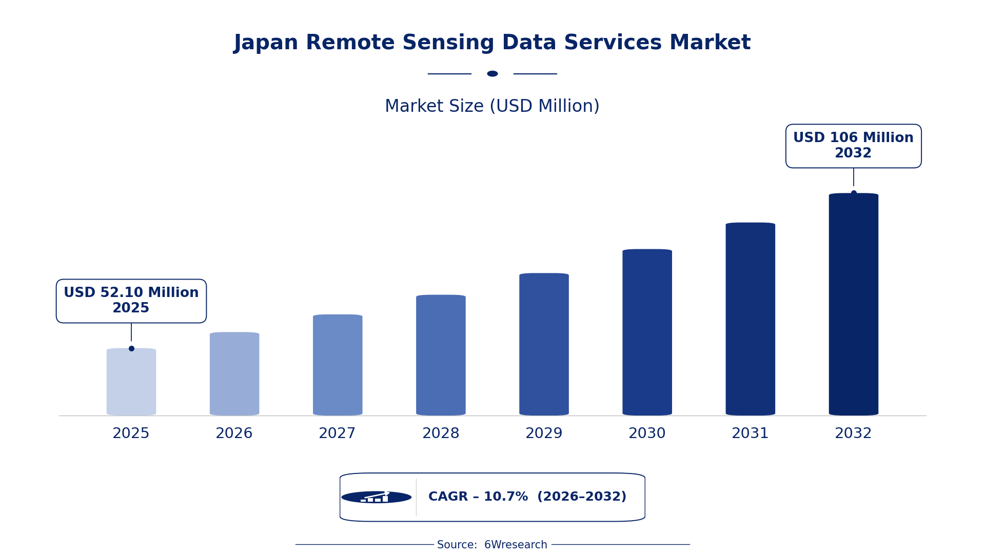
According to 6Wresearch internal database and industry insights, the Japan Remote Sensing Data Services Market was valued at USD 52.10 Million in 2025 and is projected to reach USD 106 Million by 2032, growing at a CAGR of approximately 10.7% during 2026–2032.
Japan Remote Sensing Data Services Market Highlights
| Report Metric | Details |
| Report Name | Japan Remote Sensing Data Services Market (2026-2032) |
| Market Size 2025 | USD 52.10 Million |
| Market Size 2032 | USD 106 Million |
| Absolute Growth 2025–2032 | USD 53.90 Million |
| CAGR 2026–2032 | 10.7% |
| Peak Annual Growth | 12.1% in 2029 |
| Forecast Period | 2026–2032 |
| Historical Data | 2022–2025 |
| Base Year | 2025 |
| Leading Data Type, 2025 | Satellite Imagery (42% share) |
| Leading Sensor Platform, 2025 | Optical/Radar (38% share) |
| Leading Delivery Method, 2025 | Cloud API (39% share) |
| Leading End User, 2025 | Energy Utilities (46% share) |
| Fastest-Growing Data Type | Drone Mapping (15.6% CAGR) |
| Fastest-Growing Sensor Platform | LiDAR/Multispectral (12.3% CAGR) |
| Fastest-Growing Delivery Method | GIS Integrations (15.2% CAGR) |
| Fastest-Growing End User | Pipeline Monitoring Firms (14.6% CAGR) |
| Growing Sector | Environmental monitoring |
| Key End Users | Energy Utilities, Environmental Regulatory Bodies, Urban Planners |
Japan Remote Sensing Data Services Market Year-wise Growth Rate and Key Drivers (2022–2032)
This graph illustrates the annual growth rates of the market from 2022 to 2032, highlighting a steady upward trajectory and projected market expansion over the forecast period.
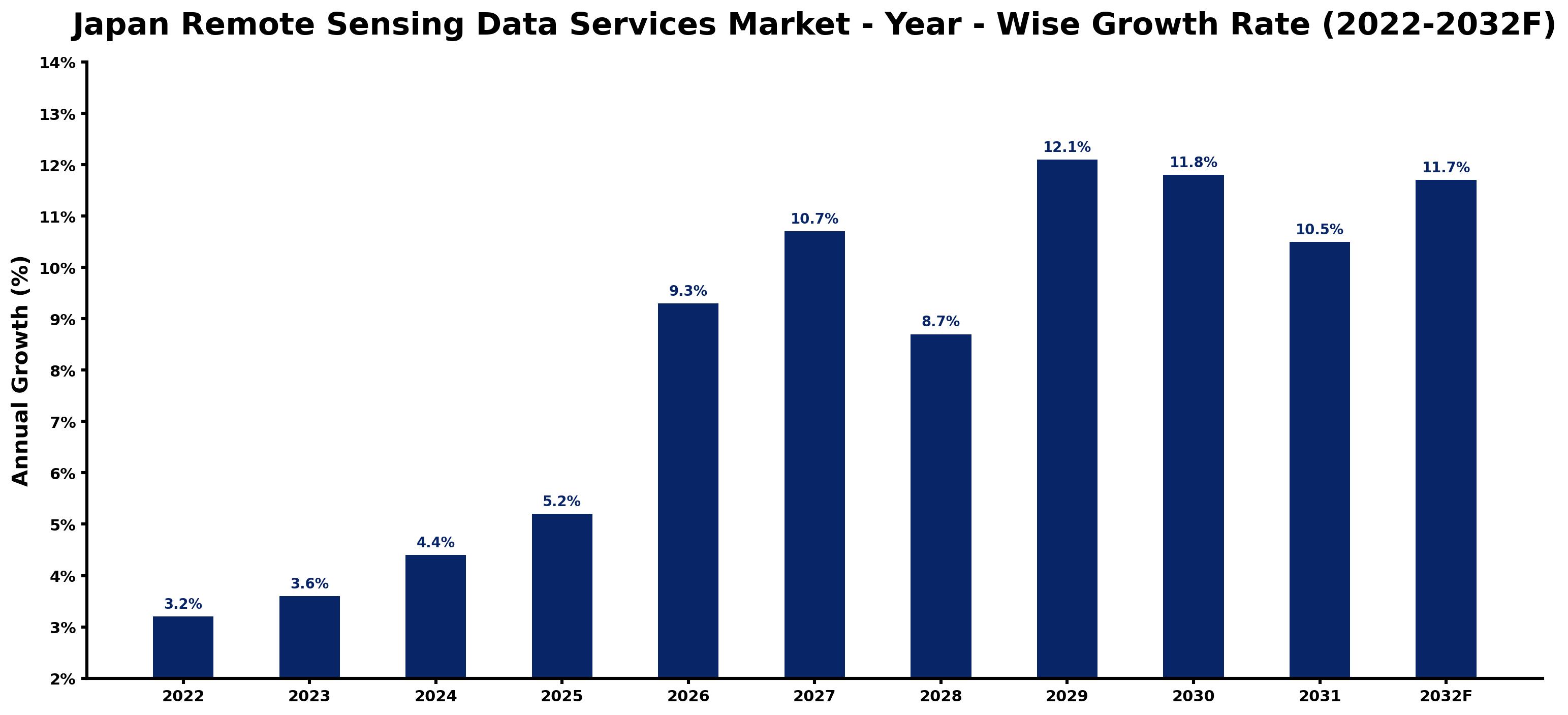
Below, each year's estimated growth is shown next to the factor that most influenced it.
| Year | Estimated Annual Growth (%) | Market Rationale |
| 2022 | 3.2 | The market exhibited steady growth, driven by increased awareness of environmental monitoring. |
| 2023 | 3.6 | Demand rose due to advancements in remote sensing technologies and applications. |
| 2024 | 4.4 | Growth accelerated as more sectors adopted remote sensing for data-driven decision-making. |
| 2025 | 5.2 | The peak historical growth rate was achieved as urban planning initiatives expanded. |
| 2026 | 9.3 | Demand is expected to surge with the introduction of new satellite technologies improving data quality. |
| 2027 | 10.7 | The market is projected to continue growing rapidly, supported by rising investments in infrastructure. |
| 2028 | 8.7 | Growth is expected to slow slightly as market maturity begins to set in, but demand will remain strong. |
| 2029 | 12.1 | The peak annual growth is projected to be reached, driven by technological advancements in remote sensing. |
| 2030 | 11.8 | Growth is expected to moderate as the market stabilises, reflecting a more mature industry. |
| 2031 | 10.5 | The market is projected to continue growing, supported by ongoing technological improvements and applications. |
| 2032 | 11.7 | Demand is expected to rise as new remote sensing applications emerge across various sectors. |
Note: Market size estimations and growth projections presented in this report are based on 6Wresearch's proprietary forecasting methodology, utilizing the latest available industry data, government publications, and primary research inputs.
Japan Remote Sensing Data Services Market Synopsis
Remote Sensing Data Services involve the collection and analysis of information from satellite imagery, drones, and ground sensors, which are essential for monitoring environmental and infrastructural changes. The Japan Remote Sensing Data Services Market is expanding due to rising demand from sectors such as energy and agriculture, driven by technological advancements and substantial investments, with over 50 billion yen allocated to remote sensing technologies in 2022. Initiatives by the Ministry of the Environment further support this growth, creating opportunities for improved data-driven decision-making across various industries.
Market Dynamics Impact Analysis (2026–2032)
| Factor | Type | Impact | Primary Segment Affected |
| Increased investment in satellite technologies | Driver | High | Satellite Imagery |
| Growing adoption of drone mapping for precision tasks | Driver | High | Drone Mapping |
| Rising need for environmental monitoring solutions | Opportunity | High | Energy Utilities |
| Expansion of urban planning initiatives requiring detailed data | Opportunity | High | Environmental Regulatory Bodies |
| Limited awareness of remote sensing benefits among smaller firms | Restraint | Medium | Ground Sensors |
| High initial costs of advanced remote sensing technologies | Restraint | Medium | LiDAR/Multispectral |
| Competition from alternative data collection methods | Challenge | Medium | Drone Mapping |
| Dependence on government funding for large projects | Challenge | High | Satellite Imagery |
Evaluation of Drivers in Japan Remote Sensing Data Services Market (2026–2032)
The factors lifting demand, and the evidence behind each, are summarised below.
| Drivers | Primary Segment Affected | Why It Matters (Evidence) |
| Growing demand for high-resolution imagery | Satellite Imagery | In 2022, Japan's investment in remote sensing technologies exceeded 50 billion yen, resulting in increased purchases from urban planners. |
| Rising use of drones for mapping and surveying | Drone Mapping | The adoption of drone technology has surged, prompting construction firms to invest more in these services. |
| Technological advancements in data processing | LiDAR/Multispectral | The increasing use of LiDAR technology in forestry management has led to more purchases by environmental agencies. |
| Integration of remote sensing with GIS | GIS Integrations | The growing need for spatial data analysis has driven demand, with GIS integrations projected to grow rapidly in the coming years. |
| Focus on disaster management strategies | Energy Utilities | Remote sensing is critical for infrastructure monitoring, especially in disaster-prone areas, leading to increased investment from utility companies. |
Most of the extra volume comes from the increasing demand for high-resolution imagery, with urban planners investing heavily in satellite data for effective decision-making. In 2022, Japan's investment in remote sensing technologies exceeded 50 billion yen, improving the capabilities of energy utilities for infrastructure monitoring. The rising use of drones for mapping and surveying has surged, prompting construction firms to adopt these technologies. The integration of remote sensing with GIS has become essential, reflecting the need for spatial data analysis in urban planning.
Evaluation of Restraints in Japan Remote Sensing Data Services Market
Several factors work against faster growth; the main ones are summarised below.
| Market Restraint | Primary Segment Affected | Why It Matters (Evidence) |
| Limited awareness of remote sensing benefits among smaller firms | Ground Sensors | Many small firms lack knowledge about the advantages of remote sensing, resulting in lower adoption rates and missed opportunities for improved data collection. |
| High initial costs of advanced remote sensing technologies | LiDAR/Multispectral | The investment required for advanced technologies can deter potential buyers, limiting market expansion among smaller entities. |
| Competition from alternative data collection methods | Drone Mapping | The rise of cost-effective alternatives such as traditional surveying can limit market share for drone mapping services. |
| Dependence on government funding for large projects | Satellite Imagery | Many large-scale projects rely on government financing, which can be unpredictable, affecting long-term planning for suppliers. |
| Regulatory hurdles in data usage | GIS Integrations | Strict regulations on data privacy and usage can hinder the adoption of GIS integrations in certain sectors. |
Japan Remote Sensing Data Services Market Challenges
A shortage of skilled professionals in remote sensing hampers the analysis of complex data, as existing training programmes fail to align with industry requirements, resulting in project delays for producers. High operational costs arise from the need for advanced technology, with annual expenses exceeding 50 billion yen, which burdens suppliers financially. Rapid technological changes require frequent upgrades, increasing costs for clinics that rely on timely information. Buyers struggle to integrate remote sensing insights into their operations, which can prolong decision-making processes in critical sectors such as agriculture and urban planning.
Trends in the Japan Remote Sensing Data Services Market
Four trends stand out in the Japan Remote Sensing Data Services Market.
- Shift towards Advanced Satellite Technologies: In 2023, Japan launched a new satellite dedicated to Earth observation, improving data collection capabilities. This initiative is expected to improve the accuracy of environmental monitoring, benefiting sectors such as agriculture and disaster management.
- Growing Adoption of Drone Technology: Drone mapping has gained traction across various sectors, particularly in urban planning, with a projected CAGR of 15.6%. This trend reflects the increasing need for precise mapping solutions in densely populated areas.
- Rise of Real-Time Data Access: The introduction of real-time streaming services for remote sensing data has transformed decision-making processes. This shift allows immediate access to critical information, particularly for emergency response teams during natural disasters.
- Integration of Remote Sensing with GIS: The integration of remote sensing data with GIS technologies has become essential for effective spatial analysis. This trend is supported by a growing demand for GIS integrations, projected to grow rapidly in the coming years.
Investment Opportunities in the Japan Remote Sensing Data Services Market
The following areas offer the clearest openings for investors and suppliers in the Japan Remote Sensing Data Services Market.
- Partnerships for Data Sharing: Now is the time for collaborations between local firms and international space agencies to improve data sharing. Such partnerships can utilise Japan's advanced satellite capabilities, driving innovation in remote sensing applications.
- Investment in Infrastructure Monitoring: With Japan's focus on disaster management, there is a pressing need for remote sensing services in infrastructure monitoring. Energy utilities are looking to invest more in these technologies to ensure safety and compliance.
- Expansion of Urban Planning Services: Urban planners are increasingly seeking remote sensing data for effective decision-making. This presents an opportunity for firms to supply advanced data services tailored to the needs of municipalities.
- Development of Real-Time Data Solutions: The demand for real-time data solutions is growing, particularly in emergency response sectors. Companies can invest in developing platforms that provide immediate access to remote sensing data.
Government Initiatives in the Japan Remote Sensing Data Services Market
The Digital Agency, established in September 2021, leads the government's digital transformation efforts, setting common system standards that impact remote sensing data services. This agency's initiatives aim to improve data accessibility and integration across various sectors, promoting the use of remote sensing in environmental monitoring and urban planning.
The Geospatial Information Authority of Japan oversees mapping and remote sensing regulations, ensuring compliance with national standards. This agency also funds projects that improve remote sensing capabilities, supporting the development of advanced technologies and their applications in sectors like agriculture and disaster management.
Future Insight of the Japan Remote Sensing Data Services Market
Advancements in satellite technology will reshape the demand for remote sensing services by 2032, improving environmental monitoring capabilities. The integration of AI in data processing will streamline analysis, enabling suppliers to deliver insights more efficiently. Partnerships with international space agencies will enhance data sharing, providing buyers with valuable information across various sectors. The adoption of standards like ISO 19115 will facilitate better data management, ensuring producers meet regulatory requirements while offering buyers consistent and reliable information.
Market Segmentation Analysis
Japan Remote Sensing Data Services Market report covers a detailed analysis of the following market segments:
By Data Type – Satellite Imagery Leads, Drone Mapping Expected to Grow Fastest
According to Saurav Kr Singh, Senior Research Analyst at 6Wresearch, Satellite Imagery held 42% of the Japan Remote Sensing Data Services Market by data type in 2025. Satellite imagery holds the largest share due to its critical role in large-scale environmental monitoring and urban planning, particularly in densely populated areas such as Tokyo. The extensive use of this data across various sectors ensures a steady demand for these services. Drone Mapping is set to record the highest CAGR in this split, 15.6% over 2026–2032. Drone mapping is witnessing rapid growth as its application in precise mapping and surveying becomes more prevalent, especially in agriculture and construction. The efficiency gained from drone technology is significantly enhancing data collection processes, leading to its increasing popularity. Suppliers should focus on enhancing drone mapping capabilities to meet the rising demand across diverse sectors.
By Sensor Platform – Optical/Radar Leads, LiDAR/Multispectral Expected to Grow Fastest
The largest sensor platform category in 2025 was Optical/Radar, at 38% of revenue. Optical and radar technologies dominate the market as they are critical for capturing high-resolution imagery and data, which are essential for disaster management and environmental studies. Their established use in various applications solidifies their leading position. LiDAR/Multispectral is projected to grow fastest, at a CAGR of 12.3% during 2026–2032. LiDAR and multispectral sensors are experiencing rapid growth due to their extensive application in detailed topographical and vegetation analysis, particularly in forestry and land management. This trend is driven by the increasing need for precision in environmental assessments. Buyers will benefit from investing in LiDAR and multispectral technologies to improve their analytical capabilities.
By Delivery Method – Cloud API Leads, GIS Integrations Expected to Grow Fastest
Cloud API took 39% of delivery method revenue in 2025, more than any other category. Cloud API is the leading delivery method because it allows seamless data access and integration for users, which is essential for efficient workflows in sectors like energy and agriculture. Its widespread adoption underscores the industry's shift towards digital solutions. Over 2026–2032, GIS Integrations are expected to post the fastest growth, at a CAGR of 15.2%. GIS integrations are experiencing rapid growth as they are crucial for effective mapping and analysis of spatial data, particularly in urban planning and environmental monitoring. This method's ability to enhance decision-making processes is driving its increasing adoption. Suppliers should prioritise the development of GIS integration solutions to cater to the growing need for spatial data analysis.
By End User – Energy Utilities Lead, Pipeline Monitoring Firms Expected to Grow Fastest
In 2025, Energy Utilities led the end user split with a 46% share. Energy utilities represent the largest share as they heavily rely on remote sensing for infrastructure monitoring and management, ensuring operational efficiency and safety. Their critical role in energy distribution necessitates advanced monitoring solutions. The quickest growth will come from Pipeline Monitoring Firms, forecast to expand at a CAGR of 14.6% between 2026 and 2032. Pipeline monitoring firms are the fastest-growing segment, relying on remote sensing for pipeline integrity and safety assessments, particularly in response to environmental regulations. The increasing focus on safety and compliance in the energy sector fuels this growth. Suppliers must tailor their offerings to meet the specific needs of pipeline monitoring firms to capitalise on this growth opportunity.
Key Attractiveness of the Report
- 10 Years of Market Numbers
- Historical Data Starting from 2022 to 2025
- Base Year 2025
- Forecast Data until 2032
- Key Performance Indicators Impacting the Market
- Major Upcoming Developments and Projects
Key Highlights of the Report:
- Japan Remote Sensing Data Services Market Outlook
- Market Size of Japan Remote Sensing Data Services Market, 2025
- Forecast of Japan Remote Sensing Data Services Market, 2032
- Historical Data and Forecast of Japan Remote Sensing Data Services Revenues & Volume for the Period 2022-2032F
- Japan Remote Sensing Data Services Market Trend Evolution
- Japan Remote Sensing Data Services Market Drivers and Challenges
- Japan Remote Sensing Data Services Price Trends
- Japan Remote Sensing Data Services Porter's Five Forces
- Japan Remote Sensing Data Services Industry Life Cycle
- Historical Data and Forecast of Japan Remote Sensing Data Services Market Revenues & Volume By Data Type for the Period 2022-2032F
- Historical Data and Forecast of Japan Remote Sensing Data Services Market Revenues & Volume By Satellite Imagery for the Period 2022-2032F
- Historical Data and Forecast of Japan Remote Sensing Data Services Market Revenues & Volume By Drone Mapping for the Period 2022-2032F
- Historical Data and Forecast of Japan Remote Sensing Data Services Market Revenues & Volume By Ground Sensors for the Period 2022-2032F
- Historical Data and Forecast of Japan Remote Sensing Data Services Market Revenues & Volume By Weather Stations for the Period 2022-2032F
- Historical Data and Forecast of Japan Remote Sensing Data Services Market Revenues & Volume By Sensor Platform for the Period 2022-2032F
- Historical Data and Forecast of Japan Remote Sensing Data Services Market Revenues & Volume By Optical/Radar for the Period 2022-2032F
- Historical Data and Forecast of Japan Remote Sensing Data Services Market Revenues & Volume By LiDAR/Multispectral for the Period 2022-2032F
- Historical Data and Forecast of Japan Remote Sensing Data Services Market Revenues & Volume By Soil/Water/Seismic for the Period 2022-2032F
- Historical Data and Forecast of Japan Remote Sensing Data Services Market Revenues & Volume By IoT Sensor Nodes for the Period 2022-2032F
- Historical Data and Forecast of Japan Remote Sensing Data Services Market Revenues & Volume By Delivery Method for the Period 2022-2032F
- Historical Data and Forecast of Japan Remote Sensing Data Services Market Revenues & Volume By Cloud API for the Period 2022-2032F
- Historical Data and Forecast of Japan Remote Sensing Data Services Market Revenues & Volume By GIS Integrations for the Period 2022-2032F
- Historical Data and Forecast of Japan Remote Sensing Data Services Market Revenues & Volume By Portal Dashboards for the Period 2022-2032F
- Historical Data and Forecast of Japan Remote Sensing Data Services Market Revenues & Volume By Real-Time Stream for the Period 2022-2032F
- Historical Data and Forecast of Japan Remote Sensing Data Services Market Revenues & Volume By End User for the Period 2022-2032F
- Historical Data and Forecast of Japan Remote Sensing Data Services Market Revenues & Volume By Energy Utilities for the Period 2022-2032F
- Historical Data and Forecast of Japan Remote Sensing Data Services Market Revenues & Volume By Pipeline Monitoring Firms for the Period 2022-2032F
- Historical Data and Forecast of Japan Remote Sensing Data Services Market Revenues & Volume By Environmental Regulatory Bodies for the Period 2022-2032F
- Historical Data and Forecast of Japan Remote Sensing Data Services Market Revenues & Volume By Renewable Energy Operators for the Period 2022-2032F
- Japan Remote Sensing Data Services Import Export Trade Statistics
- Market Opportunity Assessment By Data Type
- Market Opportunity Assessment By Sensor Platform
- Market Opportunity Assessment By Delivery Method
- Market Opportunity Assessment By End User
- Japan Remote Sensing Data Services Top Companies Market Share
- Japan Remote Sensing Data Services Competitive Benchmarking By Technical and Operational Parameters
- Japan Remote Sensing Data Services Company Profiles
- Japan Remote Sensing Data Services Key Strategic Recommendations
Market Covered
This report examines the market across the segments below.
By Data Type
- Satellite Imagery
- Drone Mapping
- Ground Sensors
- Weather Stations
By Sensor Platform
- Optical/Radar
- LiDAR/Multispectral
- Soil/Water/Seismic
- IoT Sensor Nodes
By Delivery Method
- Cloud API
- GIS Integrations
- Portal Dashboards
- Real-Time Stream
By End User
- Energy Utilities
- Pipeline Monitoring Firms
- Environmental Regulatory Bodies
- Renewable Energy Operators































