Japan Satellite Imaging for Farming Market Size & Growth Rate
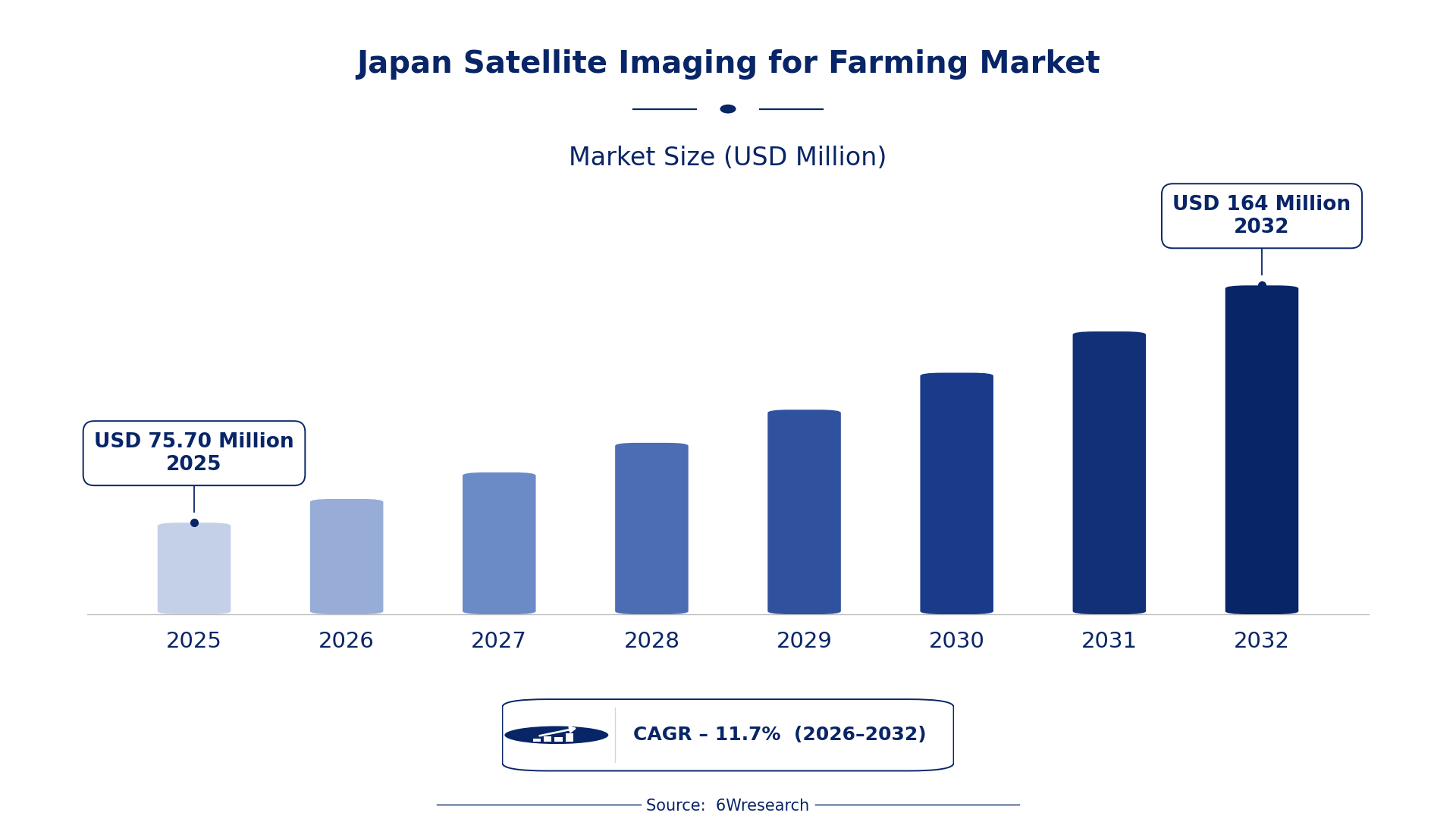
According to 6Wresearch internal database and industry insights, the Japan Satellite Imaging for Farming Market was valued at USD 75.70 Million in 2025 and is projected to reach USD 164 Million by 2032, growing at a CAGR of approximately 11.7% during 2026–2032.
Japan Satellite Imaging for Farming Market Highlights
| Report Metric | Details |
| Report Name | Japan Satellite Imaging for Farming Market (2026-2032) |
| Market Size 2025 | USD 75.70 Million |
| Market Size 2032 | USD 164 Million |
| Absolute Growth 2025–2032 | USD 88.30 Million |
| CAGR 2026–2032 | 11.7% |
| Peak Annual Growth | 12.6% in 2032 |
| Forecast Period | 2026–2032 |
| Historical Data | 2022–2025 |
| Base Year | 2025 |
| Leading Application Type, 2025 | Crop Monitoring (41% share) |
| Leading Image Type, 2025 | Multispectral (43% share) |
| Leading Delivery Platform, 2025 | Cloud-Based (35% share) |
| Leading End User, 2025 | Agribusiness Companies (41% share) |
| Fastest-Growing Application Type | Soil Moisture Mapping (15.4% CAGR) |
| Fastest-Growing Image Type | Hyperspectral (16.1% CAGR) |
| Fastest-Growing Delivery Platform | Mobile App (16.8% CAGR) |
| Fastest-Growing End User | Agritech Startups (15.3% CAGR) |
| Growing Sector | Agriculture |
| Key End Users | Agribusiness Companies, Precision Farming Firms, Agritech Startups |
Japan Satellite Imaging for Farming Market Year-wise Growth Rate and Key Drivers (2022–2032)
This graph illustrates the annual growth rates of the market from 2022 to 2032, highlighting a steady upward trajectory and projected market expansion over the forecast period.
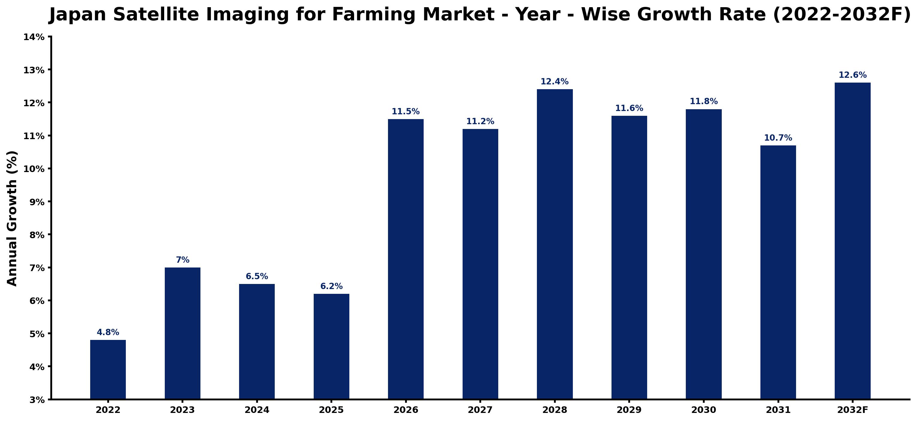
The yearly estimates that follow link every growth rate to its principal driver, so readers can see why the pace changed in each period.
| Year | Estimated Annual Growth (%) | Market Rationale |
| 2022 | 4.8 | The market showed moderate growth as agribusinesses began adopting satellite imaging technologies. |
| 2023 | 7.0 | Demand increased due to the launch of a dedicated agricultural monitoring satellite. |
| 2024 | 6.5 | Growth slowed as companies reassessed their investment strategies in precision farming. |
| 2025 | 6.2 | The market continued to grow, albeit at a slower pace as firms focused on efficiency. |
| 2026 | 11.5 | Demand surged as agritech startups introduced new solutions that utilise satellite data. |
| 2027 | 11.2 | Growth decelerated slightly as market saturation began to affect new investments. |
| 2028 | 12.4 | A renewed interest in precision farming drove demand higher once again. |
| 2029 | 11.6 | The market experienced a slowdown as competition intensified among service providers. |
| 2030 | 11.8 | Demand increased as more agribusinesses adopted cloud-based satellite imaging solutions. |
| 2031 | 10.7 | Growth moderated as the market matured and firms focused on optimisation. |
| 2032 | 12.6 | The market peaked with advancements in imaging technology improving data applications. |
Note: Market size estimations and growth projections presented in this report are based on 6Wresearch's proprietary forecasting methodology, utilizing the latest available industry data, government publications, and primary research inputs.
Japan Satellite Imaging for Farming Market Synopsis
Satellite imaging for farming utilises advanced remote sensing technologies to capture agricultural field images. This technology is essential for monitoring crop health, assessing soil moisture, predicting yields, and detecting pests. The Japan Satellite Imaging for Farming Market is expanding due to rising demand from agribusiness companies and precision farming firms, alongside government initiatives promoting smart agriculture. The launch of a dedicated satellite in 2023 increases data availability, driving investments in satellite imaging technologies across the sector.
Market Dynamics Impact Analysis (2026–2032)
| Factor | Type | Impact | Primary Segment Affected |
| Increased adoption of precision farming techniques | Driver | High | Crop Monitoring |
| Government initiatives promoting smart agriculture | Driver | High | Soil Moisture Mapping |
| Growing interest in sustainable farming practices | Opportunity | Medium | Yield Prediction |
| Expansion of agritech startups focusing on satellite solutions | Opportunity | High | Pest Detection |
| High initial investment costs for satellite imaging technologies | Restraint | High | Crop Monitoring |
| Limited awareness among smaller farms about available technologies | Restraint | Medium | Soil Moisture Mapping |
| Technological complexities in integrating satellite data | Challenge | High | Yield Prediction |
| Competition among service providers leading to pricing pressures | Challenge | Medium | Pest Detection |
Evaluation of Drivers in Japan Satellite Imaging for Farming Market (2026–2032)
Below are the drivers that matter most for revenue growth, with supporting evidence.
| Drivers | Primary Segment Affected | Why It Matters (Evidence) |
| Rising investments in precision farming | Crop Monitoring | Japan's agricultural sector employs satellite imaging to monitor over 4 million hectares, enhancing crop management. |
| Government support for smart agriculture initiatives | Soil Moisture Mapping | The Ministry of Agriculture promotes precision farming technologies, increasing demand for soil moisture mapping solutions. |
| Increasing adoption of cloud-based solutions | Yield Prediction | Cloud-based platforms enable scalable data processing, essential for accurate yield prediction in farming operations. |
| Technological advancements in satellite imaging | Pest Detection | The launch of a dedicated agricultural satellite in 2023 enhances pest detection capabilities for farmers. |
| Growing agritech startup activity | Crop Monitoring | The Tokyo region is becoming a hub for agritech startups focusing on satellite imaging solutions. |
Buyers are adding capacity as Japan's agricultural sector employs satellite imaging to monitor over 4 million hectares of farmland. The promotion of precision farming technologies boosts demand for soil moisture mapping, enabling better irrigation practices. Cloud-based platforms facilitate scalable data processing, essential for accurate yield prediction. The launch of a dedicated agricultural satellite in 2023 improves pest detection capabilities, allowing farmers to manage crop loss effectively. The agritech startup activity in the Tokyo region is driving innovation in satellite imaging solutions, leading to increased investments in the sector.
Evaluation of Restraints in Japan Satellite Imaging for Farming Market
The key brakes on demand, and where they bite hardest, are shown below.
| Market Restraint | Primary Segment Affected | Why It Matters (Evidence) |
| High initial investment costs for satellite imaging technologies | Crop Monitoring | The average farm size in Japan is about 1.5 hectares, making technology adoption costly for small farmers. |
| Limited awareness among smaller farms about available technologies | Soil Moisture Mapping | Many smaller farms lack the resources to educate themselves on the benefits of satellite imaging. |
| Technological complexities in integrating satellite data | Yield Prediction | Farmers face challenges integrating satellite data into existing systems, which affects their operations. |
| Dependence on accurate satellite data for effective implementation | Pest Detection | Inaccurate data can result in poor pest management decisions, affecting crop yields and profitability. |
| Market saturation leading to price competition | Crop Monitoring | As more providers enter the market, pricing pressures could reduce profitability for existing players. |
Japan Satellite Imaging for Farming Market Challenges
Limited access to advanced satellite imaging technology restricts farmers' ability to monitor over 4 million hectares of farmland effectively, risking yield losses of up to 20% annually for agribusinesses. Intense competition among domestic firms leads to price wars, which can shrink profit margins by 15% for suppliers. Regulatory hurdles arise from the ISO 19130 standard, delaying technology adoption and costing farmers critical time during planting seasons. Disruptions in the supply chain occur due to reliance on imported satellite data services, causing delays of up to three months for producers needing timely information.
Trends in the Japan Satellite Imaging for Farming Market
The shifts below are changing how Japan Satellite Imaging for Farming Market products are bought and supplied.
- Shift from Traditional to Precision Farming: Since 2023, agribusiness companies have increasingly adopted satellite imaging technologies for precision farming. This shift has improved crop management efficiency, with over 4 million hectares monitored, resulting in better resource allocation.
- Emergence of Agritech Startups: The Tokyo region has seen a rise in agritech startups focusing on satellite imaging solutions. In 2023, these startups contributed to innovation in agricultural practices, improving productivity across the sector.
- Transition to Cloud-Based Solutions: The adoption of cloud-based platforms for satellite data processing has accelerated since 2023. This transition allows agribusinesses to efficiently manage and analyse large datasets, improving decision-making in farming operations.
- Increased Government Support for Smart Agriculture: The Japanese government has intensified its support for smart agriculture initiatives since the launch of the 'Smart Agriculture' programme in 2023. This has led to increased funding and resources for agribusinesses adopting satellite imaging technologies.
Investment Opportunities in the Japan Satellite Imaging for Farming Market
Below are the investment opportunities with the strongest case in the Japan Satellite Imaging for Farming Market.
- Joint Ventures with Agritech Startups: By partnering with agritech startups in the Tokyo region, investors can access new satellite imaging solutions. This opportunity exists as the region's agritech activity grows, with investments expected to rise significantly.
- Expansion into Cloud-Based Services: With the growing need for cloud-based satellite data processing, companies can invest in developing these services. The expanding agribusiness sector in Japan presents a promising market for such solutions.
- Supply of Advanced Satellite Imaging Technologies: Investing in advanced satellite imaging technologies can meet the demand from agribusiness companies. The need for efficient farming practices is clear as Japan's agricultural exports reached approximately $8 billion in 2022.
- Certification for Satellite Data Standards: Obtaining ISO 19130 certification for satellite data used in agriculture can open new market opportunities. Agribusiness companies are increasingly seeking certified data to improve their operational efficiency.
Government Initiatives in the Japan Satellite Imaging for Farming Market
The Waste Management and Public Cleansing Act regulates the treatment and disposal of agricultural waste, ensuring that satellite imaging for farming adheres to environmental standards. This law requires producers to implement sustainable practices, impacting how they manage agricultural data and waste. The act has facilitated the adoption of satellite technologies, with over 100 agribusinesses benefiting from compliance measures.
The Digital Agency oversees government digital transformation efforts, including the promotion of satellite technologies. This agency provides funding for agribusinesses adopting smart agriculture practices, improving their access to satellite data and operational efficiency. In 2023, the agency allocated JPY 10 billion to support agritech initiatives.
Future Insight of the Japan Satellite Imaging for Farming Market
The launch of new agricultural satellites will improve data availability, allowing farmers to make informed decisions. Advances in technology will improve irrigation efficiency, benefiting agribusinesses in water-scarce regions. The 'Smart Agriculture' initiative will promote precision farming practices, increasing productivity for producers. Collaboration between research centres and farmers will lead to innovative applications of satellite data, ensuring competitiveness in the agricultural sector.
Market Segmentation Analysis
Japan Satellite Imaging for Farming Market report covers a detailed analysis of the following market segments:
By Application Type – Crop Monitoring Leads, Soil Moisture Mapping Expected to Grow Fastest
According to Saurav Kr Singh, Senior Research Analyst at 6Wresearch, with 41% of application type revenue in 2025, Crop Monitoring was the largest category. Crop monitoring commands a large share as it is essential for assessing crop health and growth stages across over 4 million hectares of farmland in Japan. The government's 'Smart Agriculture' initiative further promotes this application, encouraging widespread adoption among farmers. Over 2026–2032, Soil Moisture Mapping is expected to post the fastest growth, at a CAGR of 15.4%. Soil moisture mapping is experiencing rapid growth due to its critical role in optimising irrigation and water management, particularly in the Tohoku region known for diverse agricultural production. As farmers increasingly adopt these technologies, demand for soil moisture mapping is set to rise significantly. Suppliers should prioritise the development of crop monitoring and soil moisture mapping solutions to align with the growing needs of the agricultural sector.
By Image Type – Multispectral Leads, Hyperspectral Expected to Grow Fastest
Multispectral accounted for 43% of the market by image type in 2025. Multispectral imaging leads the market owing to its broad application in analysing crop health through various wavelengths, which is vital in farming practices. This imaging type is particularly effective in rice cultivation, a staple crop in Japan, solidifying its dominant position. Hyperspectral is set to record the highest CAGR in this split, 16.1% over 2026–2032. Hyperspectral imaging, while currently less common, is anticipated to grow swiftly as it provides detailed analysis that can greatly enhance farming outcomes. The increasing interest in advanced imaging techniques is likely to drive its adoption among agribusinesses. Buyers should explore investments in both multispectral and emerging hyperspectral imaging technologies to improve their agricultural practices.
By Delivery Platform – Cloud-Based Leads, Mobile App Expected to Grow Fastest
Cloud-Based held 35% of the Japan Satellite Imaging for Farming Market by delivery platform in 2025. Cloud-based platforms dominate the market as they provide scalable data processing and storage solutions, essential for managing large volumes of satellite data. This is particularly important for agribusiness companies that require reliable access to extensive datasets. The quickest growth will come from Mobile App, forecast to expand at a CAGR of 16.8% between 2026 and 2032. Mobile apps are gaining rapid traction as they enable real-time access to satellite data, allowing farmers to make timely decisions in the field. The convenience of mobile technology is driving its adoption among users seeking immediate insights. Suppliers must prioritise the development of mobile applications alongside cloud-based solutions to cater to the changing needs of farmers.
By End User – Agribusiness Companies Lead, Agritech Startups Expected to Grow Fastest
In 2025, Agribusiness Companies led the end user split with a 41% share. Agribusiness companies represent the largest user group of satellite imaging, employing these technologies to improve operational efficiency in their farming practices. Their significant investments in satellite imaging solutions underscore the importance of this segment within the agricultural market. Agritech Startups are projected to grow fastest, at a CAGR of 15.3% during 2026–2032. Agritech startups are witnessing the fastest growth as they develop new solutions that utilise satellite data for agriculture, addressing specific challenges encountered by farmers. This shift indicates a move towards more technology-driven methodologies in the agricultural sector. Suppliers should seek partnerships with agritech startups to encourage collaboration and facilitate the adoption of satellite imaging technologies.
Key Attractiveness of the Report
- 10 Years of Market Numbers
- Historical Data Starting from 2022 to 2025
- Base Year 2025
- Forecast Data until 2032
- Key Performance Indicators Impacting the Market
- Major Upcoming Developments and Projects
Key Highlights of the Report:
- Japan Satellite Imaging for Farming Market Outlook
- Market Size of Japan Satellite Imaging for Farming Market, 2025
- Forecast of Japan Satellite Imaging for Farming Market, 2032
- Historical Data and Forecast of Japan Satellite Imaging for Farming Revenues & Volume for the Period 2022-2032F
- Japan Satellite Imaging for Farming Market Trend Evolution
- Japan Satellite Imaging for Farming Market Drivers and Challenges
- Japan Satellite Imaging for Farming Price Trends
- Japan Satellite Imaging for Farming Porter's Five Forces
- Japan Satellite Imaging for Farming Industry Life Cycle
- Historical Data and Forecast of Japan Satellite Imaging for Farming Market Revenues & Volume By Application Type for the Period 2022-2032F
- Historical Data and Forecast of Japan Satellite Imaging for Farming Market Revenues & Volume By Crop Monitoring for the Period 2022-2032F
- Historical Data and Forecast of Japan Satellite Imaging for Farming Market Revenues & Volume By Soil Moisture Mapping for the Period 2022-2032F
- Historical Data and Forecast of Japan Satellite Imaging for Farming Market Revenues & Volume By Yield Prediction for the Period 2022-2032F
- Historical Data and Forecast of Japan Satellite Imaging for Farming Market Revenues & Volume By Pest Detection for the Period 2022-2032F
- Historical Data and Forecast of Japan Satellite Imaging for Farming Market Revenues & Volume By Image Type for the Period 2022-2032F
- Historical Data and Forecast of Japan Satellite Imaging for Farming Market Revenues & Volume By Multispectral for the Period 2022-2032F
- Historical Data and Forecast of Japan Satellite Imaging for Farming Market Revenues & Volume By Thermal for the Period 2022-2032F
- Historical Data and Forecast of Japan Satellite Imaging for Farming Market Revenues & Volume By Hyperspectral for the Period 2022-2032F
- Historical Data and Forecast of Japan Satellite Imaging for Farming Market Revenues & Volume By SAR for the Period 2022-2032F
- Historical Data and Forecast of Japan Satellite Imaging for Farming Market Revenues & Volume By Delivery Platform for the Period 2022-2032F
- Historical Data and Forecast of Japan Satellite Imaging for Farming Market Revenues & Volume By Mobile App for the Period 2022-2032F
- Historical Data and Forecast of Japan Satellite Imaging for Farming Market Revenues & Volume By Web Dashboard for the Period 2022-2032F
- Historical Data and Forecast of Japan Satellite Imaging for Farming Market Revenues & Volume By Cloud-Based for the Period 2022-2032F
- Historical Data and Forecast of Japan Satellite Imaging for Farming Market Revenues & Volume By API Integration for the Period 2022-2032F
- Historical Data and Forecast of Japan Satellite Imaging for Farming Market Revenues & Volume By End User for the Period 2022-2032F
- Historical Data and Forecast of Japan Satellite Imaging for Farming Market Revenues & Volume By Agribusiness Companies for the Period 2022-2032F
- Historical Data and Forecast of Japan Satellite Imaging for Farming Market Revenues & Volume By Precision Farming Firms for the Period 2022-2032F
- Historical Data and Forecast of Japan Satellite Imaging for Farming Market Revenues & Volume By Agro Consultants for the Period 2022-2032F
- Historical Data and Forecast of Japan Satellite Imaging for Farming Market Revenues & Volume By Agritech Startups for the Period 2022-2032F
- Japan Satellite Imaging for Farming Import Export Trade Statistics
- Market Opportunity Assessment By Application Type
- Market Opportunity Assessment By Image Type
- Market Opportunity Assessment By Delivery Platform
- Market Opportunity Assessment By End User
- Japan Satellite Imaging for Farming Top Companies Market Share
- Japan Satellite Imaging for Farming Competitive Benchmarking By Technical and Operational Parameters
- Japan Satellite Imaging for Farming Company Profiles
- Japan Satellite Imaging for Farming Key Strategic Recommendations
Market Covered
Segments analysed in this report are listed below.
By Application Type
- Crop Monitoring
- Soil Moisture Mapping
- Yield Prediction
- Pest Detection
By Image Type
- Multispectral
- Thermal
- Hyperspectral
- SAR
By Delivery Platform
- Mobile App
- Web Dashboard
- Cloud-Based
- API Integration
By End User
- Agribusiness Companies
- Precision Farming Firms
- Agro Consultants
- Agritech Startups































