Japan Satellite Imaging Market Size & Growth Rate
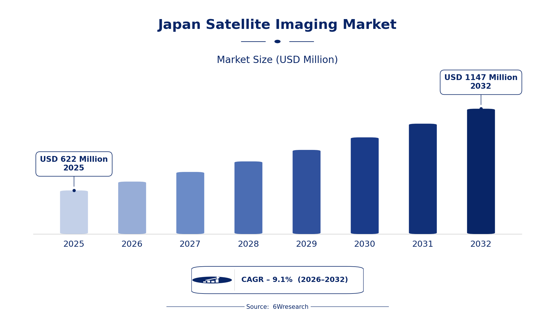
According to 6Wresearch internal database and industry insights, the Japan Satellite Imaging Market was valued at USD 622 Million in 2025 and is projected to reach USD 1,147 Million by 2032, growing at a CAGR of approximately 9.1% during 2026–2032.
Japan Satellite Imaging Market Highlights
| Report Metric | Details |
| Report Name | Japan Satellite Imaging Market (2026-2032) |
| Market Size 2025 | USD 622 Million |
| Market Size 2032 | USD 1,147 Million |
| Absolute Growth 2025–2032 | USD 525 Million |
| CAGR 2026–2032 | 9.1% |
| Peak Annual Growth | 10.5% in 2026 |
| Forecast Period | 2026–2032 |
| Historical Data | 2022–2025 |
| Base Year | 2025 |
| Leading Imaging Type, 2025 | Optical Imaging (41% share) |
| Leading Frequency Spectrum, 2025 | Visible & Near IR (47% share) |
| Leading Application Type, 2025 | Urban Planning (47% share) |
| Leading End User, 2025 | Government Bodies (37% share) |
| Fastest-Growing Imaging Type | Infrared Imaging (12.4% CAGR) |
| Fastest-Growing Frequency Spectrum | Microwave (12.3% CAGR) |
| Fastest-Growing Application Type | Environmental Monitoring (11.8% CAGR) |
| Fastest-Growing End User | Research Institutes (11.4% CAGR) |
| Growing Sector | Urban Planning |
| Key End Users | Government Bodies, Defense Departments, Research Institutes, Meteorological Agencies |
Japan Satellite Imaging Market Year-wise Growth Rate and Key Drivers (2022–2032)
This graph illustrates the annual growth rates of the market from 2022 to 2032, highlighting a steady upward trajectory and projected market expansion over the forecast period.
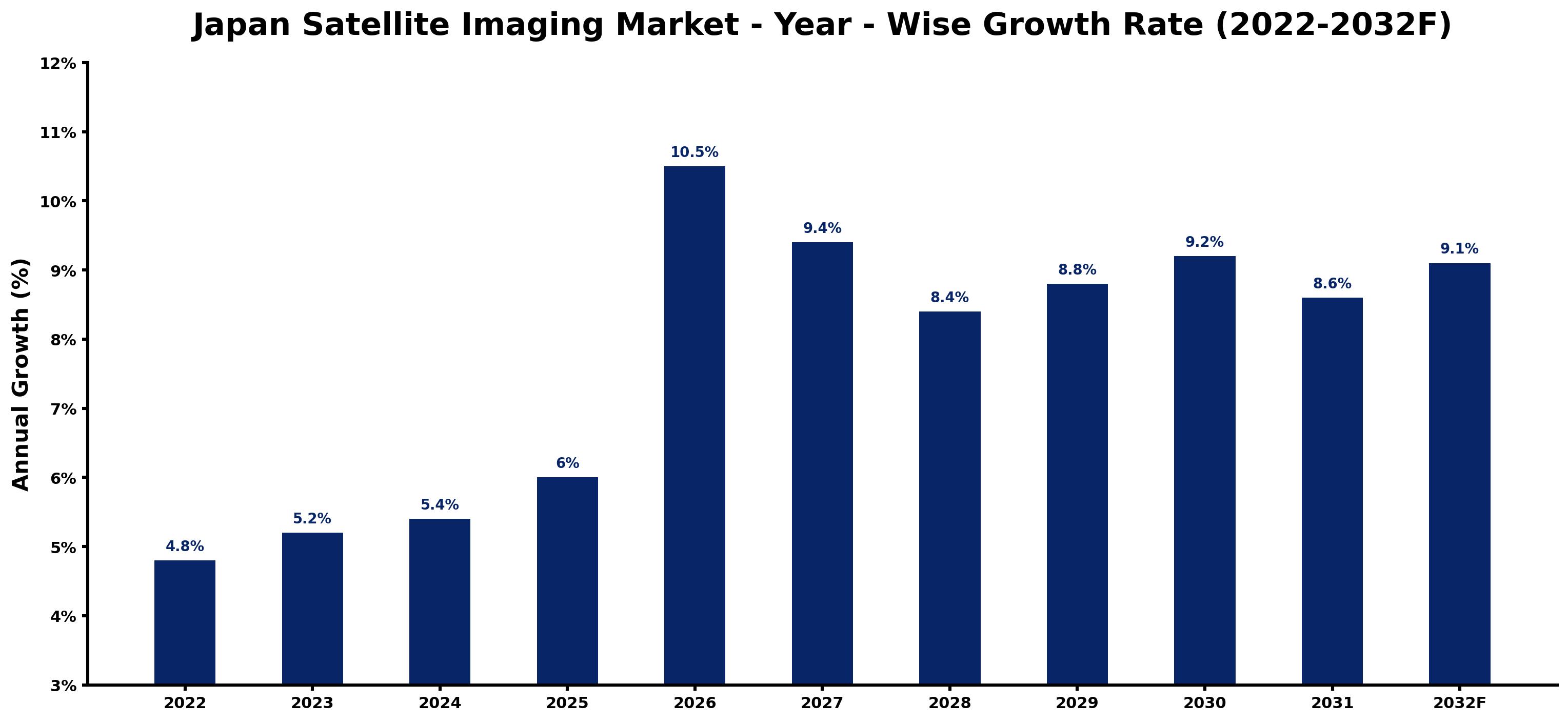
Each row of the following table gives one year's estimated growth and the event or demand shift that explains it.
| Year | Estimated Annual Growth (%) | Market Rationale |
| 2022 | 4.8 | The market showed steady growth due to ongoing satellite initiatives. |
| 2023 | 5.2 | Demand increased as urban areas expanded and required more detailed imaging. |
| 2024 | 5.4 | Growth continued with rising investments in satellite technology development. |
| 2025 | 6.0 | The peak year saw heightened interest from government bodies for urban planning. |
| 2026 | 10.5 | A surge in defense spending boosted demand for surveillance capabilities. |
| 2027 | 9.4 | Growth slowed as the market adjusted to previous high levels of investment. |
| 2028 | 8.4 | Continued interest in environmental monitoring contributed to steady growth. |
| 2029 | 8.8 | Demand increased again as research institutions adopted advanced imaging techniques. |
| 2030 | 9.2 | The market maintained momentum with ongoing urban development projects. |
| 2031 | 8.6 | A slight slowdown occurred as the market stabilised after rapid expansion. |
| 2032 | 9.1 | Growth is projected to continue with new technological advancements. |
Note: Market size estimations and growth projections presented in this report are based on 6Wresearch's proprietary forecasting methodology, utilizing the latest available industry data, government publications, and primary research inputs.
Japan Satellite Imaging Market Synopsis
Satellite imaging captures detailed images of the Earth's surface using various sensors, with primary applications in urban planning, environmental monitoring, and defense surveillance. The Japan Satellite Imaging Market is expanding due to government investment, particularly in satellite technology development, which allocated ¥10 billion in 2023. Demand arises from government bodies and research institutions seeking improved imaging capabilities for policy-making and scientific studies, alongside defense departments requiring advanced surveillance solutions.
Market Dynamics Impact Analysis (2026–2032)
| Factor | Type | Impact | Primary Segment Affected |
| Increased government funding for satellite technology | Driver | High | Urban Planning |
| Growing demand for environmental monitoring | Driver | High | Environmental Monitoring |
| Rising need for detailed mapping in urban areas | Opportunity | High | Urban Planning |
| Expanding research initiatives requiring satellite data | Opportunity | High | Research Institutes |
| High costs associated with satellite technology development | Restraint | Medium | Defense Surveillance |
| Limited access to advanced imaging technologies | Restraint | Medium | Environmental Monitoring |
| Challenges in integrating new technologies into existing systems | Challenge | High | Scientific Analysis |
| Competition among various imaging technologies | Challenge | Medium | Optical Imaging |
Evaluation of Drivers in Japan Satellite Imaging Market (2026–2032)
The factors lifting demand, and the evidence behind each, are summarised below.
| Drivers | Primary Segment Affected | Why It Matters (Evidence) |
| Government investment in satellite technology | Urban Planning | In 2023, ¥10 billion was allocated for satellite technology, driving demand for detailed urban imaging. |
| Increased focus on climate change | Environmental Monitoring | The Ministry of the Environment promotes satellite imaging for tracking climate change effects, enhancing demand. |
| Growing defense budget for surveillance | Defense Surveillance | Japan's defense budget includes significant funding for satellite capabilities, supporting national security efforts. |
| Rising urbanisation in major cities | Urban Planning | Population growth in urban areas increases the need for satellite imaging in city planning. |
| Adoption of satellite data in research | Research Institutes | Research institutions are increasingly utilising satellite data for scientific studies, driving demand. |
This funding supports urban planning capabilities, particularly in major cities where demand for detailed imaging is rising. The focus on climate change monitoring further boosts the need for satellite data, while the defense budget supports enhanced surveillance capabilities. Research institutions are increasingly adopting satellite imaging for scientific studies, driving demand for advanced imaging techniques and technologies.
Evaluation of Restraints in Japan Satellite Imaging Market
The following restraints limit how fast demand can grow.
| Market Restraint | Primary Segment Affected | Why It Matters (Evidence) |
| High costs of satellite technology development | Defense Surveillance | The investment required for satellite technology can limit budget allocations for other critical areas. |
| Limited access to advanced imaging technologies | Environmental Monitoring | Not all regions have the infrastructure to support the latest satellite imaging technologies. |
| Integration challenges with existing systems | Scientific Analysis | Incorporating new satellite technologies into current research frameworks can slow adoption. |
| Competition among imaging technologies | Optical Imaging | The presence of various imaging technologies can dilute market share and complicate buyer decisions. |
| Regulatory hurdles for satellite data usage | Urban Planning | Strict regulations can delay project approvals and limit the use of satellite data in planning. |
Japan Satellite Imaging Market Challenges
Government bodies face delays in satellite data acquisition because domestic producers struggle to meet demand, which can extend project timelines by up to six months. Research institutions encounter rising costs as suppliers deal with high operational expenses related to compliance with the ISO 19130 standard, resulting in a 15% increase in data prices. Regulatory hurdles from the Geospatial Information Authority of Japan complicate data usage, imposing additional administrative burdens on research institutions. Skills shortages in satellite imaging technology limit producers' capacity to fulfil demand, potentially leading to a 20% reduction in service availability for buyers.
Trends in the Japan Satellite Imaging Market
The trends below show where the Japan Satellite Imaging Market is heading.
- Shift from Traditional to Advanced Imaging Techniques: Since 2022, Japan has seen a transition towards advanced imaging techniques, particularly in urban planning. The increased use of Optical Imaging and Radar Imaging, which accounted for 41% and 30% of the market respectively, reflects this change.
- Emergence of Environmental Monitoring as a Priority: Environmental monitoring has gained prominence since 2023, driven by climate change concerns. The Ministry of the Environment's initiatives highlight the growing reliance on satellite imaging for tracking environmental changes.
- Growth in Research Institutions Adopting Satellite Imaging: In 2023, research institutions began increasingly adopting satellite imaging for scientific studies. This trend is expected to continue, with a projected 11.4% CAGR for this segment through 2032.
- Expansion of Defense Surveillance Capabilities: The defense sector has prioritised satellite surveillance since 2023, with increased funding for advanced imaging technologies. This focus is reflected in Japan's defense budget allocation for satellite capabilities.
Investment Opportunities in the Japan Satellite Imaging Market
Below are the investment opportunities with the strongest case in the Japan Satellite Imaging Market.
- Gap in Urban Planning Solutions: With a projected market size of USD 622 million by 2025, there is an opportunity for suppliers in urban planning solutions. Government bodies, particularly in Tokyo and Osaka, are actively seeking advanced imaging capabilities.
- Supply of Advanced Imaging Technologies: The demand for advanced imaging technologies is rising, especially in environmental monitoring. Suppliers can target government bodies and research institutions that require high-quality satellite data.
- Research Institutions Seeking Satellite Data: Research institutions are increasingly in need of satellite imaging for scientific studies, creating a market opportunity. Collaborating with local partners can facilitate entry into this sector.
- Investment in Defense Surveillance Technologies: With the defense budget focusing on satellite capabilities, there is a growing need for advanced surveillance technologies. Companies can enter this market through joint ventures with local defense contractors.
Government Initiatives in the Japan Satellite Imaging Market
The Industrial Standardization Act, amended in 2019, governs standards for satellite data quality in Japan, impacting producers and users alike. The Economic Security Promotion Act, enacted in 2022, supports supply-chain resilience for critical products, including satellite technology, ensuring compliance and safety standards for operations.
The Japan Aerospace Exploration Agency (JAXA) oversees satellite imaging initiatives, providing funding and support for various projects. The Ministry of the Environment promotes satellite imaging for environmental monitoring, approving projects that utilise satellite data for climate research and disaster response.
Future Insight of the Japan Satellite Imaging Market
Advanced imaging technologies will reshape demand for satellite data by 2032, particularly for urban planners in Tokyo and Osaka. Increased government funding will drive improvements in disaster response strategies and climate research. The establishment of international collaboration programmes will facilitate data sharing, providing essential support for research institutions. Enhanced surveillance capabilities will bolster national security efforts, ensuring Japan's defence objectives are effectively addressed.
Market Segmentation Analysis
Japan Satellite Imaging Market report covers a detailed analysis of the following market segments:
By Imaging Type – Optical Imaging Leads, Infrared Imaging Expected to Grow Fastest
According to Saurav Kr Singh, Senior Research Analyst at 6Wresearch, Optical Imaging took 41% of imaging type revenue in 2025, more than any other category. Optical Imaging holds the largest share because it is essential for detailed earth observation and mapping, which aids in urban planning and environmental assessments. The Japan Aerospace Exploration Agency extensively employs this imaging type for various projects, underscoring its market significance. Infrared Imaging is set to record the highest CAGR in this split, 12.4% over 2026–2032. Infrared Imaging is growing rapidly due to its increasing use in temperature measurement and night vision, particularly for environmental monitoring. Japan's focus on climate research and disaster management initiatives is further accelerating this segment's expansion. Suppliers should enhance Optical Imaging capabilities while also investing in Infrared technologies to meet the rising demand.
By Frequency Spectrum – Visible & Near IR Leads, Microwave Expected to Grow Fastest
Visible & Near IR held 47% of the Japan Satellite Imaging Market by frequency spectrum in 2025. Visible & Near IR leads the market as it is commonly used for vegetation and land use analysis, crucial for urban planning and agricultural assessments. This spectrum supports initiatives by the Ministry of the Environment for monitoring natural resources effectively. Microwave is projected to grow fastest, at a CAGR of 12.3% during 2026–2032. Microwave is witnessing the fastest growth due to its importance in soil moisture and atmospheric studies, which are increasingly critical for climate research. The growing emphasis on environmental monitoring initiatives is propelling this segment forward. Buyers should consider investing in Microwave technologies to leverage their advantages for environmental applications.
By Application Type – Urban Planning Leads, Environmental Monitoring Expected to Grow Fastest
The largest application type category in 2025 was Urban Planning, at 47% of revenue. Urban Planning dominates the market as it is essential for city development and infrastructure planning, with substantial demand from government bodies. The allocation of ¥10 billion by the government for satellite technology development further underscores its critical role in the sector. Over 2026–2032, Environmental Monitoring is expected to post the fastest growth, at a CAGR of 11.8%. Environmental Monitoring is the fastest-growing application, propelled by the urgent need to track climate change and natural disasters. Increased funding and focus from various ministries highlight the essential nature of this application in Japan. Suppliers must align their offerings with the growing emphasis on Environmental Monitoring to capture new opportunities.
By End User – Government Bodies Lead, Research Institutes Expected to Grow Fastest
In 2025, Government Bodies led the end user split with a 37% share. Government Bodies dominate the end-user segment as they primarily utilise satellite imaging for policy-making and resource management. Their substantial budgets for satellite technology reflect their crucial role in the market. The quickest growth will come from Research Institutes, forecast to expand at a CAGR of 11.4% between 2026 and 2032. Research Institutes are the fastest-growing end-user group, as they increasingly adopt satellite imaging for academic and scientific research. The rise in research initiatives within Japan is a significant factor driving this growth. Suppliers should target Research Institutes to expand their market reach and address the increasing demand for satellite imaging in research.
Key Attractiveness of the Report
- 10 Years of Market Numbers
- Historical Data Starting from 2022 to 2025
- Base Year 2025
- Forecast Data until 2032
- Key Performance Indicators Impacting the Market
- Major Upcoming Developments and Projects
Key Highlights of the Report:
- Japan Satellite Imaging Market Outlook
- Market Size of Japan Satellite Imaging Market, 2025
- Forecast of Japan Satellite Imaging Market, 2032
- Historical Data and Forecast of Japan Satellite Imaging Revenues & Volume for the Period 2022-2032F
- Japan Satellite Imaging Market Trend Evolution
- Japan Satellite Imaging Market Drivers and Challenges
- Japan Satellite Imaging Price Trends
- Japan Satellite Imaging Porter's Five Forces
- Japan Satellite Imaging Industry Life Cycle
- Historical Data and Forecast of Japan Satellite Imaging Market Revenues & Volume By Imaging Type for the Period 2022-2032F
- Historical Data and Forecast of Japan Satellite Imaging Market Revenues & Volume By Optical Imaging for the Period 2022-2032F
- Historical Data and Forecast of Japan Satellite Imaging Market Revenues & Volume By Radar Imaging for the Period 2022-2032F
- Historical Data and Forecast of Japan Satellite Imaging Market Revenues & Volume By Infrared Imaging for the Period 2022-2032F
- Historical Data and Forecast of Japan Satellite Imaging Market Revenues & Volume By UV Imaging for the Period 2022-2032F
- Historical Data and Forecast of Japan Satellite Imaging Market Revenues & Volume By Frequency Spectrum for the Period 2022-2032F
- Historical Data and Forecast of Japan Satellite Imaging Market Revenues & Volume By Visible & Near IR for the Period 2022-2032F
- Historical Data and Forecast of Japan Satellite Imaging Market Revenues & Volume By Microwave for the Period 2022-2032F
- Historical Data and Forecast of Japan Satellite Imaging Market Revenues & Volume By Mid-IR for the Period 2022-2032F
- Historical Data and Forecast of Japan Satellite Imaging Market Revenues & Volume By Ultraviolet for the Period 2022-2032F
- Historical Data and Forecast of Japan Satellite Imaging Market Revenues & Volume By Application Type for the Period 2022-2032F
- Historical Data and Forecast of Japan Satellite Imaging Market Revenues & Volume By Urban Planning for the Period 2022-2032F
- Historical Data and Forecast of Japan Satellite Imaging Market Revenues & Volume By Defense Surveillance for the Period 2022-2032F
- Historical Data and Forecast of Japan Satellite Imaging Market Revenues & Volume By Environmental Monitoring for the Period 2022-2032F
- Historical Data and Forecast of Japan Satellite Imaging Market Revenues & Volume By Scientific Analysis for the Period 2022-2032F
- Historical Data and Forecast of Japan Satellite Imaging Market Revenues & Volume By End User for the Period 2022-2032F
- Historical Data and Forecast of Japan Satellite Imaging Market Revenues & Volume By Government Bodies for the Period 2022-2032F
- Historical Data and Forecast of Japan Satellite Imaging Market Revenues & Volume By Defense Departments for the Period 2022-2032F
- Historical Data and Forecast of Japan Satellite Imaging Market Revenues & Volume By Meteorological Agencies for the Period 2022-2032F
- Historical Data and Forecast of Japan Satellite Imaging Market Revenues & Volume By Research Institutes for the Period 2022-2032F
- Japan Satellite Imaging Import Export Trade Statistics
- Market Opportunity Assessment By Imaging Type
- Market Opportunity Assessment By Frequency Spectrum
- Market Opportunity Assessment By Application Type
- Market Opportunity Assessment By End User
- Japan Satellite Imaging Top Companies Market Share
- Japan Satellite Imaging Competitive Benchmarking By Technical and Operational Parameters
- Japan Satellite Imaging Company Profiles
- Japan Satellite Imaging Key Strategic Recommendations
Market Covered
The following segment groups are covered in the report.
By Imaging Type
- Optical Imaging
- Radar Imaging
- Infrared Imaging
- UV Imaging
By Frequency Spectrum
- Visible & Near IR
- Microwave
- Mid-IR
- Ultraviolet
By Application Type
- Urban Planning
- Defense Surveillance
- Environmental Monitoring
- Scientific Analysis
By End User
- Government Bodies
- Defense Departments
- Meteorological Agencies
- Research Institutes































