Japan Satellite Mapping Market Size & Growth Rate
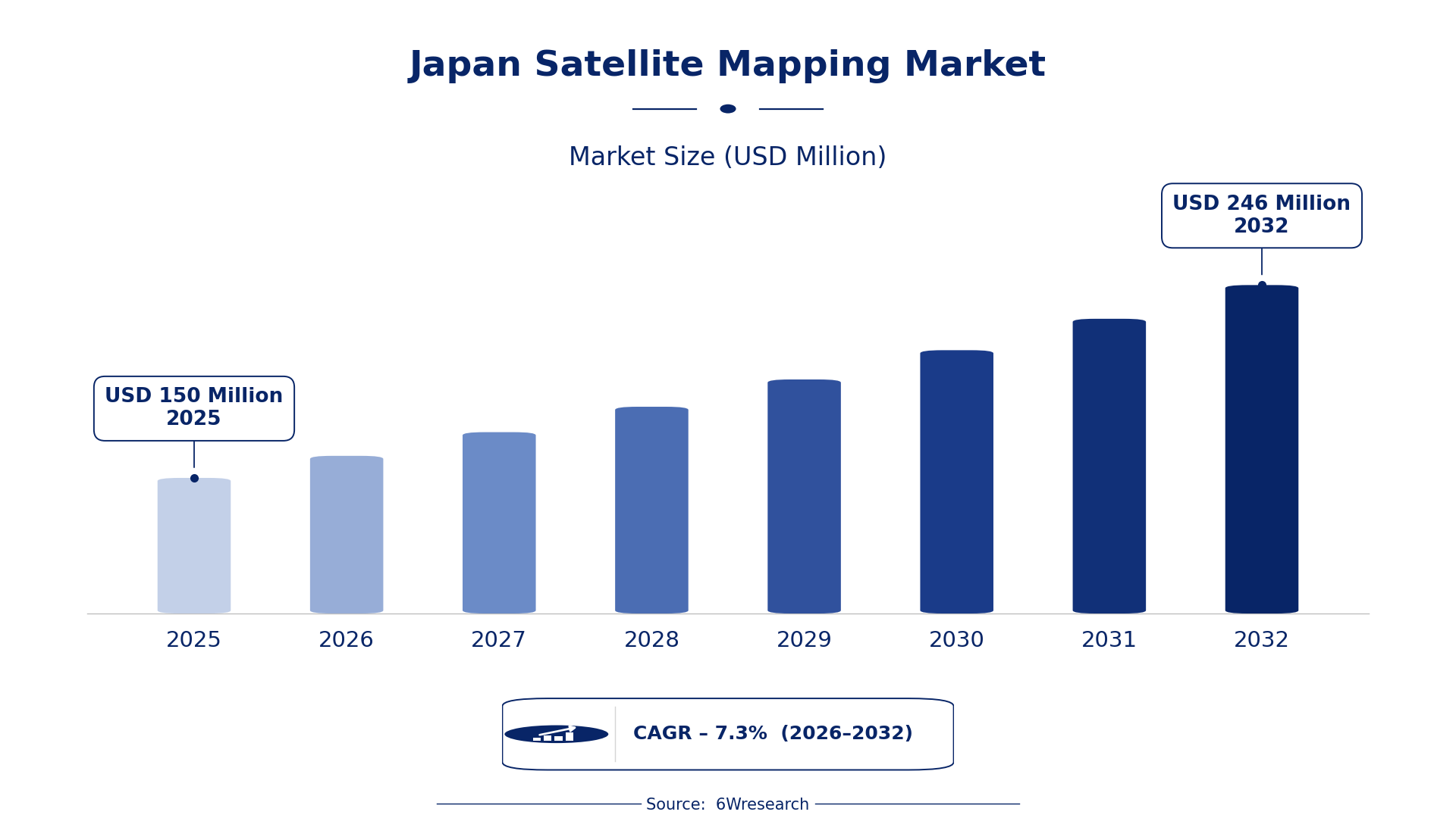
According to 6Wresearch internal database and industry insights, the Japan Satellite Mapping Market was valued at USD 150 Million in 2025 and is projected to reach USD 246 Million by 2032, growing at a CAGR of approximately 7.3% during 2026–2032.
Japan Satellite Mapping Market Highlights
| Report Metric | Details |
| Report Name | Japan Satellite Mapping Market (2026-2032) |
| Market Size 2025 | USD 150 Million |
| Market Size 2032 | USD 246 Million |
| Absolute Growth 2025–2032 | USD 96 Million |
| CAGR 2026–2032 | 7.3% |
| Peak Annual Growth | 8.5% in 2031 |
| Forecast Period | 2026–2032 |
| Historical Data | 2022–2025 |
| Base Year | 2025 |
| Leading Mapping Type, 2025 | Topographic Mapping (34% share) |
| Leading Data Source, 2025 | Optical Imagery (42% share) |
| Leading Output Format, 2025 | Digital Elevation Maps (53% share) |
| Leading End User, 2025 | Civil Engineering Firms (48% share) |
| Fastest-Growing Mapping Type | Geospatial Analytics (10.3% CAGR) |
| Fastest-Growing Data Source | Multispectral Data (10.6% CAGR) |
| Fastest-Growing Output Format | Analytical Reports (10.5% CAGR) |
| Fastest-Growing End User | Environmental Scientists (9.5% CAGR) |
| Growing Sector | Civil Engineering |
| Key End Users | Civil Engineering Firms, Environmental Scientists, Urban Planners |
Japan Satellite Mapping Market Year-wise Growth Rate and Key Drivers (2022–2032)
This graph illustrates the annual growth rates of the market from 2022 to 2032, highlighting a steady upward trajectory and projected market expansion over the forecast period.
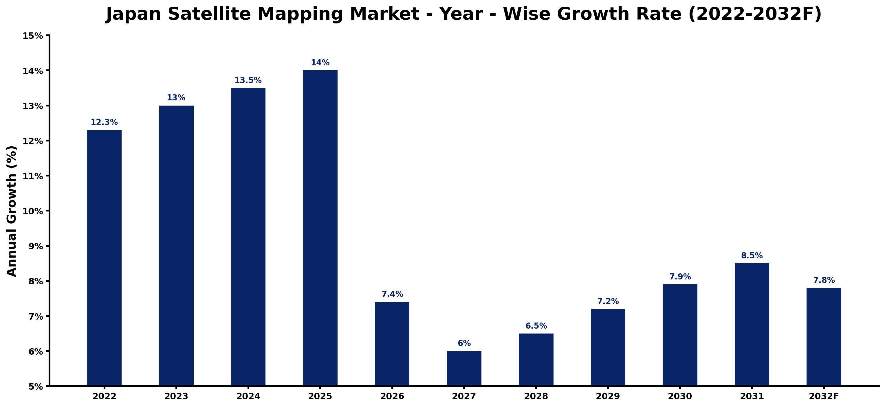
Each row of the following table gives one year's estimated growth and the event or demand shift that explains it.
| Year | Estimated Annual Growth (%) | Market Rationale |
| 2022 | 12.3 | Demand for satellite mapping services increased due to urban planning initiatives. |
| 2023 | 13.0 | The launch of a new satellite improved earth observation capabilities, boosting demand. |
| 2024 | 13.5 | Continued investment in disaster management strategies drove higher mapping needs. |
| 2025 | 14.0 | The Tokyo metropolitan area saw growth in civil engineering projects requiring mapping. |
| 2026 | 7.4 | Demand growth slowed as the market adjusted to previous peak levels. |
| 2027 | 6.0 | A decrease in government funding for satellite projects contributed to slower growth. |
| 2028 | 6.5 | Rising interest in environmental monitoring spurred demand for mapping services. |
| 2029 | 7.2 | Increased agricultural monitoring needs led to higher demand for multispectral data. |
| 2030 | 7.9 | Urban planning initiatives continued to drive demand for detailed mapping solutions. |
| 2031 | 8.5 | The introduction of advanced analytical tools increased demand for satellite mapping. |
| 2032 | 7.8 | Growth slowed as the market matured and competition intensified. |
Note: Market size estimations and growth projections presented in this report are based on 6Wresearch's proprietary forecasting methodology, utilizing the latest available industry data, government publications, and primary research inputs.
Japan Satellite Mapping Market Synopsis
Satellite mapping utilises satellite imagery to create detailed maps and analyse geographical data, essential for urban planning, environmental monitoring, and resource management. The Japan Satellite Mapping Market is expanding due to a growing population of approximately 126 million, driving demand from civil engineering firms and government projects. The launch of new satellites and advancements in technology are improving mapping capabilities, further attracting interest from various sectors, including environmental science and urban planning.
Market Dynamics Impact Analysis (2026–2032)
| Factor | Type | Impact | Primary Segment Affected |
| Increasing urbanisation in the Tokyo metropolitan area | Driver | High | Land Use Mapping |
| Rising environmental concerns driving monitoring efforts | Driver | High | Climate Mapping |
| Growing demand for disaster management solutions | Opportunity | High | Topographic Mapping |
| Investment in advanced satellite technologies | Opportunity | Medium | Geospatial Analytics |
| High costs associated with satellite data acquisition | Restraint | High | Optical Imagery |
| Limited access to advanced satellite technology for smaller firms | Restraint | Medium | Multispectral Data |
| Competition from emerging mapping technologies | Challenge | High | Digital Elevation Maps |
| Dependence on government funding for satellite projects | Challenge | Medium | Analytical Reports |
Evaluation of Drivers in Japan Satellite Mapping Market (2026–2032)
These are the developments adding the most demand over the forecast period.
| Drivers | Primary Segment Affected | Why It Matters (Evidence) |
| Urban planning initiatives in the Tokyo metropolitan area | Land Use Mapping | These initiatives require detailed mapping to support infrastructure development and resource management. |
| Environmental monitoring needs due to climate change | Climate Mapping | Increased awareness of environmental issues drives demand for accurate mapping data. |
| Investment in disaster management strategies | Topographic Mapping | Japan's mountainous terrain necessitates precise topographic data for effective disaster response. |
| Technological advancements in satellite imagery | Geospatial Analytics | Improved imaging technology increases data accuracy, attracting more users for analysis. |
| Rising agricultural monitoring requirements | Multispectral Data | Farmers and agricultural firms seek detailed data for crop management and yield prediction. |
Approximately 126 million people in Japan are driving demand for satellite mapping services. Environmental monitoring needs are also rising, particularly due to climate change, leading to increased requests for climate mapping data. Investment in disaster management strategies necessitates accurate topographic mapping, especially in mountainous regions. Advancements in satellite imagery technology improve data accuracy, attracting more users for geospatial analytics.
Evaluation of Restraints in Japan Satellite Mapping Market
These are the pressures that could keep growth below its potential.
| Market Restraint | Primary Segment Affected | Why It Matters (Evidence) |
| High costs associated with satellite data acquisition | Optical Imagery | The financial investment required limits access for smaller firms and projects. |
| Limited access to advanced satellite technology for smaller firms | Multispectral Data | Many smaller enterprises struggle to afford or access the latest satellite technologies. |
| Competition from emerging mapping technologies | Digital Elevation Maps | New technologies may offer lower-cost alternatives, impacting traditional mapping services. |
| Dependence on government funding for satellite projects | Analytical Reports | Funding fluctuations can delay projects and reduce mapping service availability. |
| Regulatory challenges in data usage and sharing | Geospatial Analytics | Strict regulations can hinder the ability to fully utilise mapping data. |
Japan Satellite Mapping Market Challenges
Japan's recent satellite launch encountered technical issues, causing delays in urban planning projects and increasing costs by 15% for local governments. Professionals in the mapping sector often lack specialised training in satellite data analysis, which diminishes service quality and affects project outcomes for clients. Supply chain disruptions for satellite components have raised production costs by 20%, forcing producers to increase prices for buyers in civil engineering. Strict regulations from the Geospatial Information Authority can prolong project approvals, delaying essential services for disaster management in vulnerable regions.
Trends in the Japan Satellite Mapping Market
The trends below show where the Japan Satellite Mapping Market is heading.
- Shift towards Enhanced Environmental Monitoring: Environmental scientists are increasingly adopting satellite mapping for climate studies, particularly since 2023, when Japan launched a new satellite for improved observation capabilities, enhancing data accuracy.
- Transition from Traditional to Advanced Mapping Technologies: Civil engineering firms are moving towards advanced mapping technologies, reflecting the need for more precise planning in infrastructure projects.
- Emergence of Real-Time Mapping Solutions: In 2023, the introduction of real-time satellite data processing began transforming mapping services, enabling quicker decision-making for urban planners and emergency responders.
- Growing Integration of AI in Mapping Services: Since the AI Promotion Act in 2025, there has been a notable shift towards integrating AI in satellite mapping, improving data analysis and interpretation for various sectors.
Investment Opportunities in the Japan Satellite Mapping Market
Below are the investment opportunities with the strongest case in the Japan Satellite Mapping Market.
- Partnerships with Local Governments: Now is an ideal time for firms to partner with local governments on mapping projects, especially in urban planning, as Japan allocates funds for infrastructure development.
- Investment in Advanced Satellite Technologies: With a projected increase in demand for satellite mapping, investing in advanced satellite technologies is essential for firms looking to improve their service offerings.
- Supply of Multispectral Data Solutions: Environmental scientists are increasingly seeking multispectral data for agricultural monitoring, presenting a timely opportunity for suppliers to meet this demand.
- Collaboration with Civil Engineering Firms: Civil engineering firms require detailed mapping for infrastructure projects, making it a prime opportunity for service providers to enter this growing market.
Government Initiatives in the Japan Satellite Mapping Market
The AI Promotion Act, established in 2025, creates a national framework for AI research and development, improving the capabilities of satellite mapping technologies. This act complements earlier laws, such as the Digital Agency's establishment in 2021, which supports digital transformation across sectors, including mapping.
In 2022, Japan allocated USD 100 million for advanced satellite technology development, overseen by the Geospatial Information Authority. This agency ensures compliance with mapping standards and promotes the use of satellite mapping in various applications.
Future Insight of the Japan Satellite Mapping Market
By 2032, the introduction of high-resolution imagery will transform demand for satellite mapping, particularly in urban planning. The implementation of ISO 19115 will improve data management efficiency, benefiting both suppliers and buyers. New initiatives for environmental monitoring will prioritise sustainable practices in agriculture and urban development. As Japan invests in advanced satellite capabilities, the market will evolve towards integrated mapping solutions that cater to diverse applications, including disaster management and resource allocation.
Market Segmentation Analysis
Japan Satellite Mapping Market report covers a detailed analysis of the following market segments:
By Mapping Type – Topographic Mapping Leads, Geospatial Analytics Expected to Grow Fastest
According to Saurav Kr Singh, Senior Research Analyst at 6Wresearch, Topographic Mapping accounted for 34% of the market by mapping type in 2025. Topographic mapping holds the largest share due to its critical role in terrain analysis and planning, especially in Japan's mountainous regions. Its importance is underscored by its use in disaster management, where accurate topographical data is essential for effective response strategies. Geospatial Analytics is set to record the highest CAGR in this split, 10.3% over 2026–2032. Geospatial analytics is experiencing rapid growth as it becomes increasingly vital for data analysis and informed decision-making. The rise in government funding for advanced satellite technology development is further accelerating this segment's expansion. Suppliers should focus on enhancing their geospatial analytics capabilities to meet the growing demand.
By Data Source – Optical Imagery Leads, Multispectral Data Expected to Grow Fastest
With 42% of data source revenue in 2025, Optical Imagery was the largest category. Optical imagery dominates the market as it is extensively used for capturing visual data of the Earth, which is crucial for various applications. Its widespread adoption in urban planning projects, particularly in the Tokyo metropolitan area, highlights its significance. The quickest growth will come from Multispectral Data, forecast to expand at a CAGR of 10.6% between 2026 and 2032. Multispectral data is growing quickly due to its effectiveness in analysing different wavelengths of light, essential for agricultural monitoring. The increasing emphasis on precision agriculture in Japan's rural areas is a key factor driving this growth. Buyers will benefit from investing in multispectral data solutions to improve agricultural monitoring and resource management.
By Output Format – Digital Elevation Maps Lead, Analytical Reports Expected to Grow Fastest
The largest output format category in 2025 was Digital Elevation Maps, at 53% of revenue. Digital elevation maps are the leading output format because they are essential for 3D terrain modelling and analysis, particularly in flood risk assessments. Their application in coastal areas demonstrates their importance in disaster preparedness and urban planning. Over 2026–2032, Analytical Reports are expected to post the fastest growth, at a CAGR of 10.5%. Analytical reports are seeing the fastest growth as they provide detailed analysis and decision support, increasingly required by various sectors. The demand for comprehensive insights from satellite data is fuelling this segment's rapid expansion. Suppliers should prioritise the development of analytical report capabilities to cater to the increasing need for detailed data analysis.
By End User – Civil Engineering Firms Lead, Environmental Scientists Expected to Grow Fastest
Civil Engineering Firms took 48% of end user revenue in 2025, more than any other category. Civil engineering firms represent the largest share of end users as they rely heavily on mapping for project planning and execution. Extensive civil engineering projects in regions like Chubu necessitate accurate and detailed mapping services. Environmental Scientists are projected to grow fastest, at a CAGR of 9.5% during 2026–2032. Environmental scientists are the fastest-growing end user group, driven by their need for mapping in research and conservation efforts. The Ministry of the Environment's promotion of satellite mapping for environmental monitoring significantly contributes to this growth. Suppliers must tailor their offerings to meet the specific needs of environmental scientists, who are increasingly relying on advanced mapping solutions.
Key Attractiveness of the Report
- 10 Years of Market Numbers
- Historical Data Starting from 2022 to 2025
- Base Year 2025
- Forecast Data until 2032
- Key Performance Indicators Impacting the Market
- Major Upcoming Developments and Projects
Key Highlights of the Report:
- Japan Satellite Mapping Market Outlook
- Market Size of Japan Satellite Mapping Market, 2025
- Forecast of Japan Satellite Mapping Market, 2032
- Historical Data and Forecast of Japan Satellite Mapping Revenues & Volume for the Period 2022-2032F
- Japan Satellite Mapping Market Trend Evolution
- Japan Satellite Mapping Market Drivers and Challenges
- Japan Satellite Mapping Price Trends
- Japan Satellite Mapping Porter's Five Forces
- Japan Satellite Mapping Industry Life Cycle
- Historical Data and Forecast of Japan Satellite Mapping Market Revenues & Volume By Mapping Type for the Period 2022-2032F
- Historical Data and Forecast of Japan Satellite Mapping Market Revenues & Volume By Topographic Mapping for the Period 2022-2032F
- Historical Data and Forecast of Japan Satellite Mapping Market Revenues & Volume By Land Use Mapping for the Period 2022-2032F
- Historical Data and Forecast of Japan Satellite Mapping Market Revenues & Volume By Geospatial Analytics for the Period 2022-2032F
- Historical Data and Forecast of Japan Satellite Mapping Market Revenues & Volume By Climate Mapping for the Period 2022-2032F
- Historical Data and Forecast of Japan Satellite Mapping Market Revenues & Volume By Data Source for the Period 2022-2032F
- Historical Data and Forecast of Japan Satellite Mapping Market Revenues & Volume By Optical Imagery for the Period 2022-2032F
- Historical Data and Forecast of Japan Satellite Mapping Market Revenues & Volume By Multispectral Data for the Period 2022-2032F
- Historical Data and Forecast of Japan Satellite Mapping Market Revenues & Volume By SAR + Optical for the Period 2022-2032F
- Historical Data and Forecast of Japan Satellite Mapping Market Revenues & Volume By Hyperspectral for the Period 2022-2032F
- Historical Data and Forecast of Japan Satellite Mapping Market Revenues & Volume By Output Format for the Period 2022-2032F
- Historical Data and Forecast of Japan Satellite Mapping Market Revenues & Volume By Digital Elevation Maps for the Period 2022-2032F
- Historical Data and Forecast of Japan Satellite Mapping Market Revenues & Volume By GIS Format for the Period 2022-2032F
- Historical Data and Forecast of Japan Satellite Mapping Market Revenues & Volume By Analytical Reports for the Period 2022-2032F
- Historical Data and Forecast of Japan Satellite Mapping Market Revenues & Volume By Satellite Models for the Period 2022-2032F
- Historical Data and Forecast of Japan Satellite Mapping Market Revenues & Volume By End User for the Period 2022-2032F
- Historical Data and Forecast of Japan Satellite Mapping Market Revenues & Volume By Civil Engineering Firms for the Period 2022-2032F
- Historical Data and Forecast of Japan Satellite Mapping Market Revenues & Volume By Urban Planners for the Period 2022-2032F
- Historical Data and Forecast of Japan Satellite Mapping Market Revenues & Volume By Mining Industry for the Period 2022-2032F
- Historical Data and Forecast of Japan Satellite Mapping Market Revenues & Volume By Environmental Scientists for the Period 2022-2032F
- Japan Satellite Mapping Import Export Trade Statistics
- Market Opportunity Assessment By Mapping Type
- Market Opportunity Assessment By Data Source
- Market Opportunity Assessment By Output Format
- Market Opportunity Assessment By End User
- Japan Satellite Mapping Top Companies Market Share
- Japan Satellite Mapping Competitive Benchmarking By Technical and Operational Parameters
- Japan Satellite Mapping Company Profiles
- Japan Satellite Mapping Key Strategic Recommendations
Market Covered
The study includes the following segmentation.
By Mapping Type
- Topographic Mapping
- Land Use Mapping
- Geospatial Analytics
- Climate Mapping
By Data Source
- Optical Imagery
- Multispectral Data
- SAR + Optical
- Hyperspectral
By Output Format
- Digital Elevation Maps
- GIS Format
- Analytical Reports
- Satellite Models
By End User
- Civil Engineering Firms
- Urban Planners
- Mining Industry
- Environmental Scientists































