Japan Smart Aerial Mapping for Farms Market Size & Growth Rate
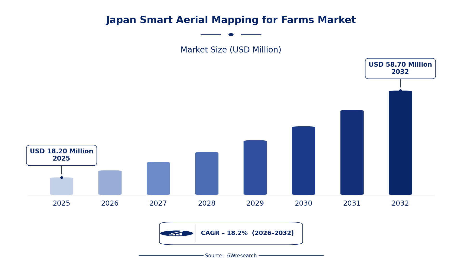
According to 6Wresearch internal database and industry insights, the Japan Smart Aerial Mapping for Farms Market was valued at USD 18.20 Million in 2025 and is projected to reach USD 58.70 Million by 2032, growing at a CAGR of approximately 18.2% during 2026–2032.
Japan Smart Aerial Mapping for Farms Market Highlights
| Report Metric | Details |
| Report Name | Japan Smart Aerial Mapping for Farms Market (2026-2032) |
| Market Size 2025 | USD 18.20 Million |
| Market Size 2032 | USD 58.70 Million |
| Absolute Growth 2025–2032 | USD 40.50 Million |
| CAGR 2026–2032 | 18.2% |
| Peak Annual Growth | 19.4% in 2032 |
| Forecast Period | 2026–2032 |
| Historical Data | 2022–2025 |
| Base Year | 2025 |
| Leading Mapping Type, 2025 | Multispectral Mapping (43% share) |
| Leading Technology Used, 2025 | Drone + NDVI Sensors (35% share) |
| Leading Output Provided, 2025 | Crop Health Maps (47% share) |
| Leading End User, 2025 | Precision Farming Firms (41% share) |
| Fastest-Growing Mapping Type | Thermal Mapping (25.1% CAGR) |
| Fastest-Growing Technology Used | IR Camera + UAV (20.7% CAGR) |
| Fastest-Growing Output Provided | Soil Moisture/Heat Stress (23.7% CAGR) |
| Fastest-Growing End User | Agri-Tech Startups (23.5% CAGR) |
| Growing Sector | Agri-Tech Startups |
| Key End Users | Precision Farming Firms, Agri-Tech Startups, Agricultural Surveyors, Farm Equipment Suppliers |
Japan Smart Aerial Mapping for Farms Market Year-wise Growth Rate and Key Drivers (2022–2032)
This graph illustrates the annual growth rates of the market from 2022 to 2032, highlighting a steady upward trajectory and projected market expansion over the forecast period.
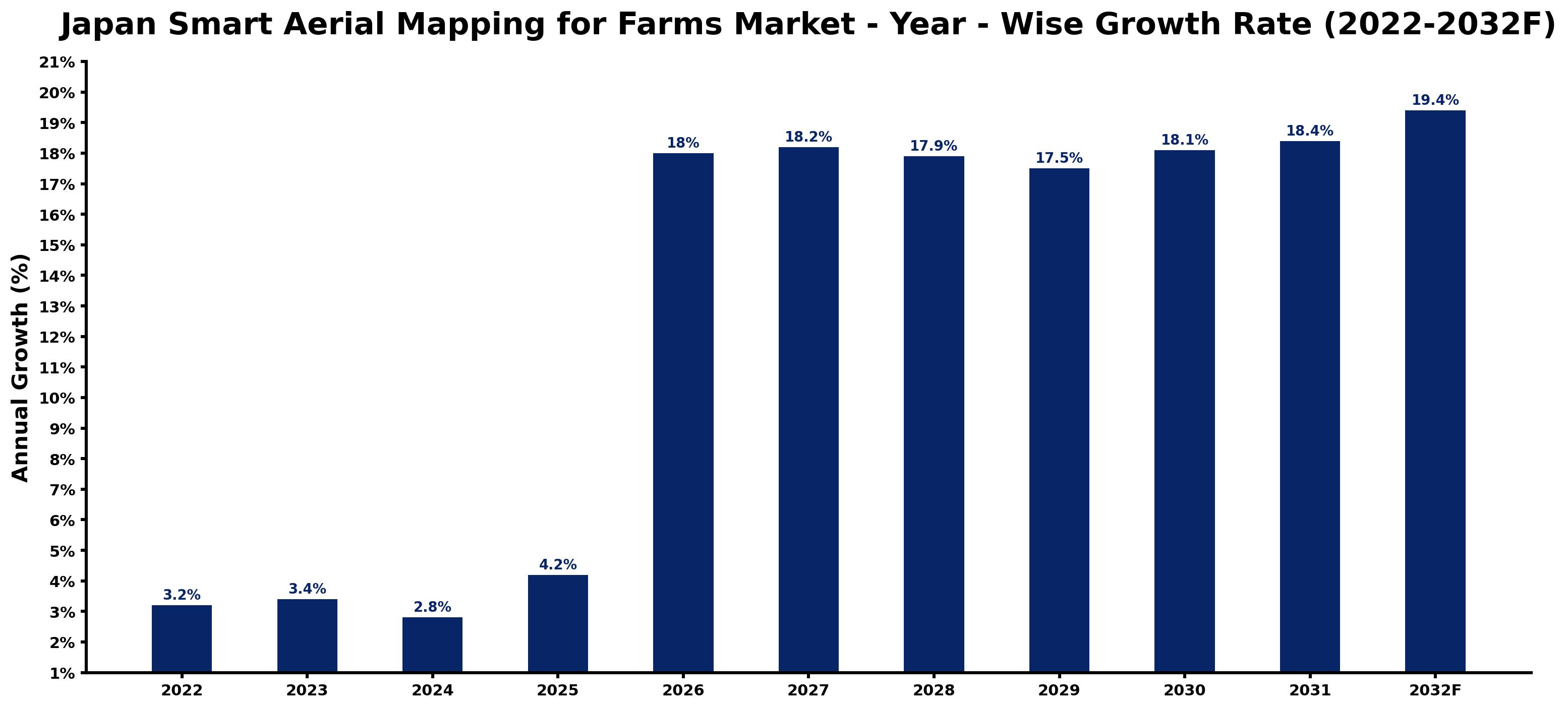
Each row of the following table gives one year's estimated growth and the event or demand shift that explains it.
| Year | Estimated Annual Growth (%) | Market Rationale |
| 2022 | 3.2 | The market experienced steady growth due to increasing awareness of aerial mapping technologies. |
| 2023 | 3.4 | Demand rose as precision farming firms sought advanced solutions for crop management. |
| 2024 | 2.8 | Growth slowed as market participants adjusted to new technologies and practices. |
| 2025 | 4.2 | A surge in efficiency reported by precision farming firms drove renewed interest in aerial mapping. |
| 2026 | 18.0 | The introduction of new drone technologies is expected to spark demand increases. |
| 2027 | 18.2 | Continued advancements in imaging technologies will support ongoing market expansion. |
| 2028 | 17.9 | Growth is projected to slow as the market begins to stabilise after rapid advancements. |
| 2029 | 17.5 | A slight slowdown is expected as firms consolidate their investments in aerial mapping. |
| 2030 | 18.1 | Demand will accelerate again as new applications for aerial data emerge in agriculture. |
| 2031 | 18.4 | Technological advancements will continue to drive market growth and adoption rates. |
| 2032 | 19.4 | The market is projected to peak as precision farming firms maximise efficiency through aerial mapping. |
Note: Market size estimations and growth projections presented in this report are based on 6Wresearch's proprietary forecasting methodology, utilizing the latest available industry data, government publications, and primary research inputs.
Japan Smart Aerial Mapping for Farms Market Synopsis
Smart Aerial Mapping for Farms utilises drones equipped with sensors to gather critical data on agricultural fields. This technology enables farmers to assess crop health, monitor soil conditions, and optimise farming practices. The Japan Smart Aerial Mapping for Farms Market is expanding due to increasing demand from precision farming firms and agri-tech startups, with growth driven by the adoption of advanced imaging technologies. In 2023, the government allocated ¥2 billion for agricultural innovation programs, further supporting market expansion.
Market Dynamics Impact Analysis (2026–2032)
| Factor | Type | Impact | Primary Segment Affected |
| Increasing adoption of precision farming techniques | Driver | High | Drone + NDVI Sensors |
| Growing demand for crop health monitoring | Driver | High | Crop Health Maps |
| Expansion of agri-tech startups | Opportunity | High | Agri-Tech Startups |
| Rising interest in sustainable farming practices | Opportunity | High | Precision Farming Firms |
| Limited awareness among traditional farmers | Restraint | Medium | RGB Imaging |
| High initial investment costs for drones | Restraint | Medium | Thermal Mapping |
| Regulatory hurdles in drone usage | Challenge | High | Lidar-based Mapping |
| Competition from alternative mapping technologies | Challenge | Medium | 3D Aerial Models |
Evaluation of Drivers in Japan Smart Aerial Mapping for Farms Market (2026–2032)
The main growth drivers and the segments they affect most are set out below.
| Drivers | Primary Segment Affected | Why It Matters (Evidence) |
| Increased efficiency reported by precision farming firms | Crop Health Maps | Precision farming firms report a 40% increase in efficiency when using aerial mapping technologies. |
| Growing acreage analysed through multispectral mapping | Multispectral Mapping | Over 300,000 hectares of rice fields are analysed annually using multispectral mapping techniques. |
| Government support for drone technology in agriculture | Drone + NDVI Sensors | Government initiatives promote the adoption of drone technology in agricultural practices. |
| Rising need for real-time crop monitoring | Real-time Crop View | Farmers increasingly require immediate data to make informed decisions about crop management. |
| Expansion of agri-tech startups | Agri-Tech Startups | The number of agri-tech startups in Japan has increased by 25% since 2021, driving demand for aerial mapping. |
Orders keep climbing as precision farming firms increasingly utilise aerial mapping technologies to improve productivity. In Japan, over 300,000 hectares of rice fields are analysed annually through multispectral mapping, enabling farmers to make data-driven decisions. Reports indicate a 40% efficiency increase among precision farming firms using crop health maps, which are now essential for modern agricultural practices. The rise of agri-tech startups, which have surged by 25% since 2021, is contributing to the growing demand for aerial mapping solutions.
Evaluation of Restraints in Japan Smart Aerial Mapping for Farms Market
The main factors holding the market back are set out below.
| Market Restraint | Primary Segment Affected | Why It Matters (Evidence) |
| Limited awareness among traditional farmers | RGB Imaging | Many traditional farmers lack knowledge about the benefits of aerial mapping technologies, hindering adoption rates. |
| High initial investment costs for drones | Thermal Mapping | The substantial upfront costs associated with drone technology deter potential users from investing in aerial mapping solutions. |
| Regulatory hurdles in drone usage | Lidar-based Mapping | Complex regulations surrounding drone operations can delay implementation and usage in farming applications. |
| Competition from alternative mapping technologies | 3D Aerial Models | Emerging technologies may divert attention and investment away from established aerial mapping solutions. |
| Limited integration with existing farming practices | Soil Moisture/Heat Stress | Challenges in integrating aerial mapping with traditional farming methods can restrict overall market growth. |
Japan Smart Aerial Mapping for Farms Market Challenges
Competition from international drone manufacturers pressures local producers to reduce prices, causing a 15% decline in market share for Japanese firms. Buyers struggle to adopt aerial mapping due to the average farm size of 1.5 hectares, limiting their ability to justify the investment in technology. High costs associated with advanced imaging technologies delay implementation for precision farming firms, who experience a 40% efficiency increase but face initial capital constraints. Supply chain disruptions in the Tohoku region, a hub for precision farming, lead to service delivery delays for buyers, impacting their operational efficiency.
Trends in the Japan Smart Aerial Mapping for Farms Market
Several trends are reshaping the Japan Smart Aerial Mapping for Farms Market; the most important are set out below.
- Shift towards Real-time Data Utilisation: In 2023, precision farming firms increasingly adopted real-time crop monitoring solutions, improving decision-making capabilities. This shift is illustrated by the growing use of real-time crop view technologies, which enable immediate insights into crop conditions.
- Growth of Agri-Tech Startups: Since 2021, the number of agri-tech startups in Japan has surged by 25%, indicating a strong interest in advanced agricultural solutions. This trend highlights the rising demand for aerial mapping technologies among new market entrants.
- Increased Focus on Sustainable Farming Practices: The agricultural sector is shifting towards sustainability, with precision farming firms adopting aerial mapping to optimise resource usage. This trend is evident in the Tohoku region, where sustainable practices are gaining traction.
- Growing Adoption of Multispectral Mapping: Multispectral mapping has become essential for assessing crop health, with over 300,000 hectares of rice fields analysed annually. This trend underscores the importance of advanced imaging technologies in modern agriculture.
Investment Opportunities in the Japan Smart Aerial Mapping for Farms Market
Where to invest in the Japan Smart Aerial Mapping for Farms Market: the main openings are set out below.
- Partnerships with Agri-Tech Startups: Establishing partnerships with agri-tech startups presents a valuable opportunity, as these firms increasingly seek aerial mapping solutions. Collaborating with these firms can lead to increased market penetration, especially in urban farming initiatives.
- Investment in Drone Technology: With the government's allocation of ¥2 billion for agricultural innovation programs, there is a strong opportunity to invest in drone technology. Precision farming firms are actively seeking advanced solutions to improve their operations.
- Expansion in the Tohoku Region: The Tohoku region is currently experiencing a surge in precision farming technologies. Suppliers can enter this market by collaborating with local agricultural cooperatives to provide tailored aerial mapping solutions.
- Development of Training Programs for Farmers: As awareness of aerial mapping technologies grows, developing training programs for traditional farmers presents a valuable opportunity. Educating farmers on the benefits of these technologies can drive adoption and usage.
Government Initiatives in the Japan Smart Aerial Mapping for Farms Market
The Economic Security Promotion Act (2022) supports supply-chain resilience for critical products, including agricultural technologies. This act encourages investment in domestic production capabilities, ensuring that producers of aerial mapping technologies can rely on stable supply chains and local resources.
In 2023, the Japanese government allocated ¥2 billion for agricultural innovation programs, administered by the Ministry of Agriculture, Forestry and Fisheries. This funding aims to increase the adoption of advanced technologies, including aerial mapping solutions, benefiting farmers across the country.
Future Insight of the Japan Smart Aerial Mapping for Farms Market
A policy-driven shift will reshape agricultural practices, with increased government support for drone technology. By 2032, advancements in imaging technologies will enhance irrigation management, particularly in drought-prone areas, benefiting farmers significantly. Suppliers will develop more affordable aerial mapping solutions, making them accessible to smaller farms. The rise of agri-tech startups will drive innovation, creating new opportunities for both buyers and suppliers in this evolving landscape.
Market Segmentation Analysis
Japan Smart Aerial Mapping for Farms Market report covers a detailed analysis of the following market segments:
By Mapping Type – Multispectral Mapping Leads, Thermal Mapping Expected to Grow Fastest
According to Saurav Kr Singh, Senior Research Analyst at 6Wresearch, with 43% of mapping type revenue in 2025, Multispectral Mapping was the largest category. Multispectral mapping holds the largest share due to its crucial role in assessing crop health and soil conditions across Japan's agricultural fields. This method is particularly relevant in the Tohoku region, where over 300,000 hectares of rice fields are analysed each year. Over 2026–2032, Thermal Mapping is expected to post the fastest growth, at a CAGR of 25.1%. Thermal mapping is experiencing rapid growth as it plays a vital role in monitoring plant stress and managing irrigation in drought-prone areas. The increasing focus on efficient water management is driving farmers to adopt this technology more widely. Suppliers should focus on developing thermal mapping solutions to meet the rising demand from agricultural producers.
By Technology Used – Drone + NDVI Sensors Lead, IR Camera + UAV Expected to Grow Fastest
The largest technology used category in 2025 was Drone + NDVI Sensors, at 35% of revenue. The combination of drone technology with NDVI sensors leads the market as it is essential for precision agriculture applications. This integration enables farmers to gain detailed insights, significantly improving their operational efficiency in managing crops. IR Camera + UAV is projected to grow fastest, at a CAGR of 20.7% during 2026–2032. IR camera and UAV technology is rapidly gaining traction due to its effectiveness in detecting crop health issues. The growth of agri-tech startups is further accelerating the demand for this advanced technology in the market. Buyers should consider investing in IR camera and UAV technology to enhance their capabilities in precision farming.
By Output Provided – Crop Health Maps Lead, Soil Moisture/Heat Stress Expected to Grow Fastest
Crop Health Maps held 47% of the Japan Smart Aerial Mapping for Farms Market by output provided in 2025. Crop health maps are the leading output as they provide vital information for farmers to make informed decisions regarding their crops. Over 70% of precision farming firms in Japan rely on these maps for effective management. Soil Moisture/Heat Stress is set to record the highest CAGR in this split, 23.7% over 2026–2032. Soil moisture and heat stress outputs are growing quickly as they are important for irrigation management, particularly in regions facing water scarcity. This demand is driven by the need for efficient resource utilisation in agriculture. Suppliers must prioritise the development of soil moisture and heat stress outputs to cater to evolving agricultural practices.
By End User – Precision Farming Firms Lead, Agri-Tech Startups Expected to Grow Fastest
In 2025, Precision Farming Firms led the end user split with a 41% share. Precision farming firms represent the largest user group of aerial mapping technologies, employing these tools to optimise their agricultural practices across Japan's diverse landscape. With over 1.5 million farms in the country, this segment constitutes a substantial market for smart aerial mapping solutions. The quickest growth will come from Agri-Tech Startups, forecast to expand at a CAGR of 23.5% between 2026 and 2032. Agri-tech startups are emerging as the fastest-growing user segment, utilising aerial data for innovative agricultural solutions. Their notable 25% growth since 2021 underscores a strong trend towards technology integration in farming. Suppliers should tailor their offerings to meet the specific needs of agri-tech startups to capitalise on this expanding market.
Key Attractiveness of the Report
- 10 Years of Market Numbers
- Historical Data Starting from 2022 to 2025
- Base Year 2025
- Forecast Data until 2032
- Key Performance Indicators Impacting the Market
- Major Upcoming Developments and Projects
Key Highlights of the Report:
- Japan Smart Aerial Mapping for Farms Market Outlook
- Market Size of Japan Smart Aerial Mapping for Farms Market, 2025
- Forecast of Japan Smart Aerial Mapping for Farms Market, 2032
- Historical Data and Forecast of Japan Smart Aerial Mapping for Farms Revenues & Volume for the Period 2022-2032F
- Japan Smart Aerial Mapping for Farms Market Trend Evolution
- Japan Smart Aerial Mapping for Farms Market Drivers and Challenges
- Japan Smart Aerial Mapping for Farms Price Trends
- Japan Smart Aerial Mapping for Farms Porter's Five Forces
- Japan Smart Aerial Mapping for Farms Industry Life Cycle
- Historical Data and Forecast of Japan Smart Aerial Mapping for Farms Market Revenues & Volume By Mapping Type for the Period 2022-2032F
- Historical Data and Forecast of Japan Smart Aerial Mapping for Farms Market Revenues & Volume By Multispectral Mapping for the Period 2022-2032F
- Historical Data and Forecast of Japan Smart Aerial Mapping for Farms Market Revenues & Volume By Thermal Mapping for the Period 2022-2032F
- Historical Data and Forecast of Japan Smart Aerial Mapping for Farms Market Revenues & Volume By Lidar-based Mapping for the Period 2022-2032F
- Historical Data and Forecast of Japan Smart Aerial Mapping for Farms Market Revenues & Volume By RGB Imaging for the Period 2022-2032F
- Historical Data and Forecast of Japan Smart Aerial Mapping for Farms Market Revenues & Volume By Technology Used for the Period 2022-2032F
- Historical Data and Forecast of Japan Smart Aerial Mapping for Farms Market Revenues & Volume By Drone + NDVI Sensors for the Period 2022-2032F
- Historical Data and Forecast of Japan Smart Aerial Mapping for Farms Market Revenues & Volume By IR Camera + UAV for the Period 2022-2032F
- Historical Data and Forecast of Japan Smart Aerial Mapping for Farms Market Revenues & Volume By 3D Aerial Models for the Period 2022-2032F
- Historical Data and Forecast of Japan Smart Aerial Mapping for Farms Market Revenues & Volume By High-Res Cameras for the Period 2022-2032F
- Historical Data and Forecast of Japan Smart Aerial Mapping for Farms Market Revenues & Volume By Output Provided for the Period 2022-2032F
- Historical Data and Forecast of Japan Smart Aerial Mapping for Farms Market Revenues & Volume By Crop Health Maps for the Period 2022-2032F
- Historical Data and Forecast of Japan Smart Aerial Mapping for Farms Market Revenues & Volume By Soil Moisture/Heat Stress for the Period 2022-2032F
- Historical Data and Forecast of Japan Smart Aerial Mapping for Farms Market Revenues & Volume By Terrain Profiling for the Period 2022-2032F
- Historical Data and Forecast of Japan Smart Aerial Mapping for Farms Market Revenues & Volume By Real-time Crop View for the Period 2022-2032F
- Historical Data and Forecast of Japan Smart Aerial Mapping for Farms Market Revenues & Volume By End User for the Period 2022-2032F
- Historical Data and Forecast of Japan Smart Aerial Mapping for Farms Market Revenues & Volume By Precision Farming Firms for the Period 2022-2032F
- Historical Data and Forecast of Japan Smart Aerial Mapping for Farms Market Revenues & Volume By Agri-Tech Startups for the Period 2022-2032F
- Historical Data and Forecast of Japan Smart Aerial Mapping for Farms Market Revenues & Volume By Agricultural Surveyors for the Period 2022-2032F
- Historical Data and Forecast of Japan Smart Aerial Mapping for Farms Market Revenues & Volume By Farm Equipment Suppliers for the Period 2022-2032F
- Japan Smart Aerial Mapping for Farms Import Export Trade Statistics
- Market Opportunity Assessment By Mapping Type
- Market Opportunity Assessment By Technology Used
- Market Opportunity Assessment By Output Provided
- Market Opportunity Assessment By End User
- Japan Smart Aerial Mapping for Farms Top Companies Market Share
- Japan Smart Aerial Mapping for Farms Competitive Benchmarking By Technical and Operational Parameters
- Japan Smart Aerial Mapping for Farms Company Profiles
- Japan Smart Aerial Mapping for Farms Key Strategic Recommendations
Market Covered
The report covers the following segments.
By Mapping Type
- Multispectral Mapping
- Thermal Mapping
- Lidar-based Mapping
- RGB Imaging
By Technology Used
- Drone + NDVI Sensors
- IR Camera + UAV
- 3D Aerial Models
- High-Res Cameras
By Output Provided
- Crop Health Maps
- Soil Moisture/Heat Stress
- Terrain Profiling
- Real-time Crop View
By End User
- Precision Farming Firms
- Agri-Tech Startups
- Agricultural Surveyors
- Farm Equipment Suppliers































