Japan Terrain Mapping Air Sensor Market Size & Growth Rate
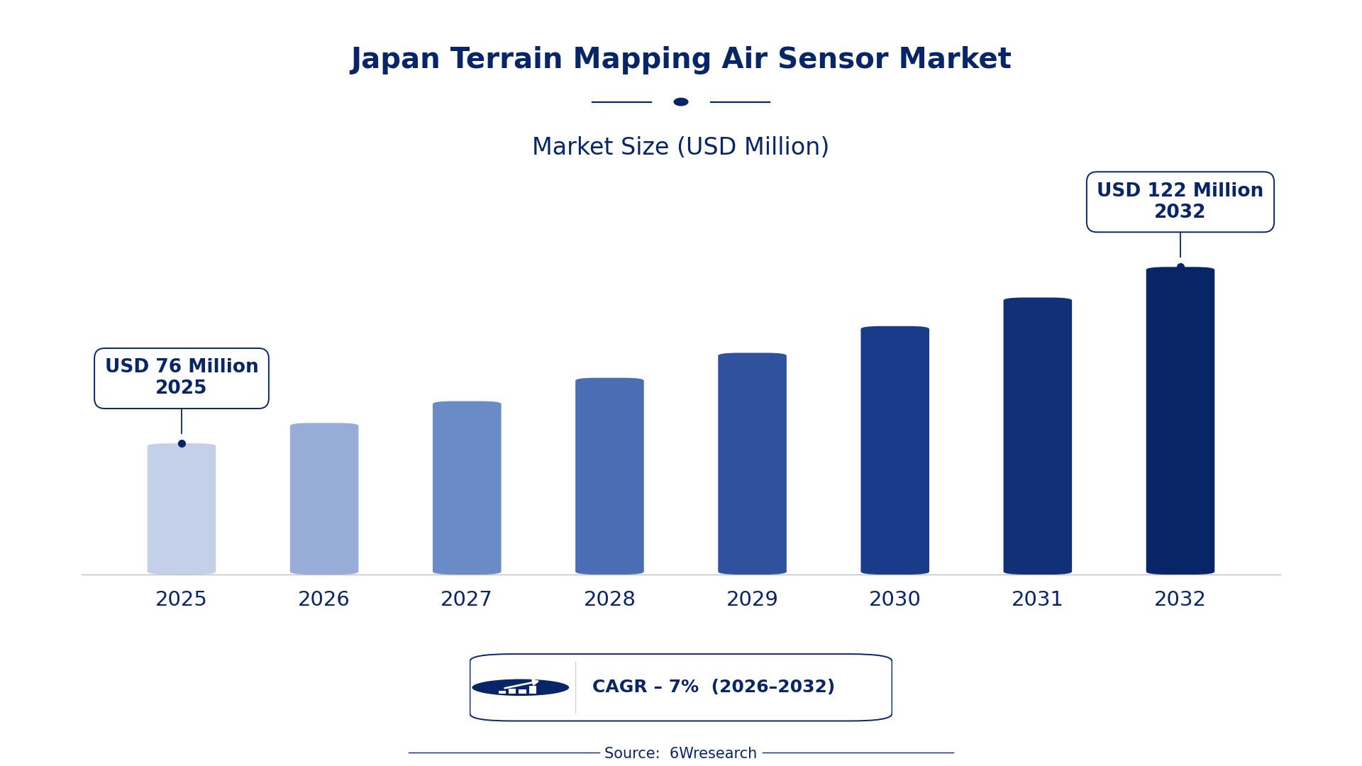
According to 6Wresearch internal database and industry insights, the Japan Terrain Mapping Air Sensor Market was valued at USD 76 Million in 2025 and is projected to reach USD 122 Million by 2032, growing at a CAGR of approximately 7% during 2026–2032.
Japan Terrain Mapping Air Sensor Market Highlights
| Report Metric | Details |
| Report Name | Japan Terrain Mapping Air Sensor Market (2026-2032) |
| Market Size 2025 | USD 76 Million |
| Market Size 2032 | USD 122 Million |
| Absolute Growth 2025–2032 | USD 46 Million |
| CAGR 2026–2032 | 7% |
| Peak Annual Growth | 8.7% in 2032 |
| Forecast Period | 2026–2032 |
| Historical Data | 2022–2025 |
| Base Year | 2025 |
| Leading Terrain Mapping Air Sensor, 2025 | LIDAR Mapping Systems (43% share) |
| Leading Product Type, 2025 | Airborne LIDAR (38% share) |
| Leading Sensor Tech, 2025 | LiDAR (46% share) |
| Leading Distribution Channel, 2025 | Geospatial Suppliers (51% share) |
| Leading End User Industry, 2025 | Mapping Agencies (35% share) |
| Fastest-Growing Terrain Mapping Air Sensor | 3D Imaging Sensors (9.9% CAGR) |
| Fastest-Growing Product Type | Optical Mapping (10.1% CAGR) |
| Fastest-Growing Sensor Tech | Photogrammetry (9.5% CAGR) |
| Fastest-Growing Distribution Channel | OEM Aerial Platforms (9.3% CAGR) |
| Fastest-Growing End User Industry | Survey & GIS (9.7% CAGR) |
| Growing Sector | Urban Planning |
| Key End Users | Mapping Agencies, Survey & GIS, Environmental Monitoring, Urban Planning |
Japan Terrain Mapping Air Sensor Market Year-wise Growth Rate and Key Drivers (2022–2032)
This graph illustrates the annual growth rates of the market from 2022 to 2032, highlighting a steady upward trajectory and projected market expansion over the forecast period.
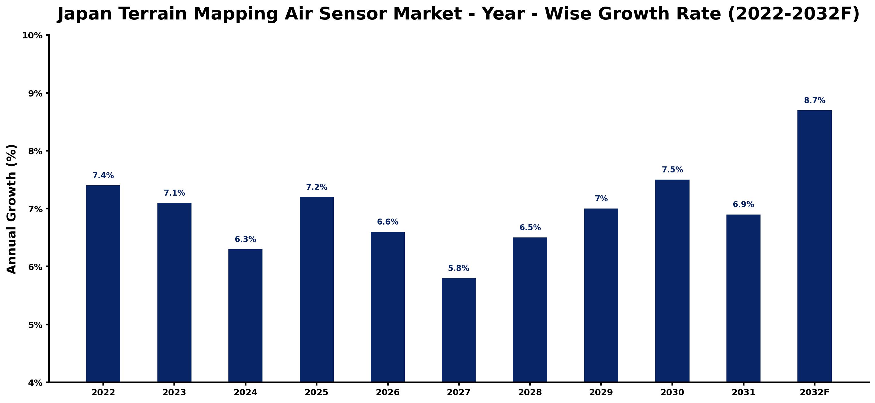
For each year, the table pairs the estimated growth rate with the leading influence on demand, showing how the drivers changed across the period.
| Year | Estimated Annual Growth (%) | Market Rationale |
| 2022 | 7.4 | The market experienced strong demand from urban planning and environmental monitoring sectors. |
| 2023 | 7.1 | Growth slowed due to market saturation in certain applications and increased competition. |
| 2024 | 6.3 | Demand continued to decelerate as buyers adjusted to previous investments and technology adoption. |
| 2025 | 7.2 | Growth accelerated as infrastructure projects resumed, boosting demand for terrain mapping solutions. |
| 2026 | 6.6 | The market is expected to slow as economic uncertainties affect investment in new technologies. |
| 2027 | 5.8 | Growth will continue to decelerate as buyers focus on optimising existing systems rather than new purchases. |
| 2028 | 6.5 | Demand is projected to increase again as urban planning initiatives gain momentum in major cities. |
| 2029 | 7.0 | Growth is expected to pick up as environmental monitoring projects expand, requiring advanced mapping technologies. |
| 2030 | 7.5 | Demand will rise further due to increased government funding for infrastructure and disaster management. |
| 2031 | 6.9 | Growth is projected to slow slightly as the market matures and competition intensifies among suppliers. |
| 2032 | 8.7 | The market is expected to peak as demand surges from new infrastructure projects and enhanced geospatial data initiatives. |
Note: Market size estimations and growth projections presented in this report are based on 6Wresearch's proprietary forecasting methodology, utilizing the latest available industry data, government publications, and primary research inputs.
Japan Terrain Mapping Air Sensor Market Synopsis
Terrain Mapping Air Sensors capture high-resolution geographical data using laser scanning technology, facilitating applications in environmental monitoring, urban planning, and infrastructure surveying. The Japan Terrain Mapping Air Sensor Market is growing due to rising demand from over 1,200 mapping agencies and a government target to increase LIDAR technology use by 30% by 2025. The launch of a geospatial data collection program in 2023 is further driving demand, creating opportunities for advanced sensor technologies.
Market Dynamics Impact Analysis (2026–2032)
| Factor | Type | Impact | Primary Segment Affected |
| Increased urbanisation in key regions | Driver | High | LIDAR Mapping Systems |
| Growing government investment in infrastructure projects | Driver | High | 3D Imaging Sensors |
| Rising demand for environmental monitoring solutions | Opportunity | High | Environmental Monitoring |
| Expansion of geospatial data collection initiatives | Opportunity | Medium | Mapping Agencies |
| High competition among suppliers leading to pricing pressures | Restraint | High | Survey & GIS |
| Limited awareness of advanced sensor technologies among smaller agencies | Restraint | Medium | Urban Planning |
| Challenges in integrating new technologies into existing systems | Challenge | High | LiDAR |
| Dependence on government funding for infrastructure projects | Challenge | Medium | Airborne LIDAR |
Evaluation of Drivers in Japan Terrain Mapping Air Sensor Market (2026–2032)
Key forces behind demand, with the segment each one moves most, are listed below.
| Drivers | Primary Segment Affected | Why It Matters (Evidence) |
| Increased urbanisation in Tokyo and Osaka | LIDAR Mapping Systems | Urban planning projects account for over 60% of sensor use, driving demand for precise mapping solutions. |
| Government initiatives for disaster management | 3D Imaging Sensors | The Ministry of the Environment promotes these sensors, leading to heightened demand for accurate environmental assessments. |
| Growing infrastructure projects across Japan | Airborne LIDAR | Infrastructure investments are projected to increase sensor purchases, supporting market growth. |
| Rising need for climate change adaptation measures | Environmental Monitoring | The 2023 program for enhanced geospatial data collection is driving demand for advanced monitoring technologies. |
| Increased focus on precision agriculture | Multi-spectral Imaging | Agricultural assessments across prefectures are driving demand for advanced imaging technologies. |
Buyers are adding capacity as urbanisation in Tokyo and Osaka fuels demand for precise mapping solutions, with urban planning projects accounting for over 60% of sensor applications. The focus on precision agriculture across various prefectures is pushing the adoption of advanced sensor technologies, increasing investments in these solutions.
Evaluation of Restraints in Japan Terrain Mapping Air Sensor Market
These are the pressures that could keep growth below its potential.
| Market Restraint | Primary Segment Affected | Why It Matters (Evidence) |
| High competition among suppliers | Survey & GIS | This leads to pricing pressures, making it difficult for smaller players to compete effectively in the market. |
| Limited awareness of advanced technologies | Urban Planning | Many smaller agencies struggle to adopt new sensor technologies, hindering their operational efficiency. |
| Integration challenges with existing systems | LiDAR | Many buyers face difficulties in incorporating new technologies into their established workflows. |
| Dependence on government funding | Airborne LIDAR | Market growth is closely tied to public investments, which can fluctuate based on political priorities. |
| Regulatory compliance costs | 3D Imaging Sensors | Meeting JIS standards increases operational costs for manufacturers, affecting pricing strategies. |
Japan Terrain Mapping Air Sensor Market Challenges
Buyers in the terrain mapping air sensor market encounter supply chain disruptions due to reliance on specific components, causing delays in project timelines and raising costs by 15% for government agencies. Regulatory requirements, such as adherence to ISO 9001 standards, complicate manufacturing processes, resulting in longer approval times that can postpone product launches by six months for producers. Rising production costs, driven by Japan's minimum wage increase to JPY 1,055 per hour, strain budgets, forcing producers to raise prices and affecting affordability for smaller mapping agencies. Skills shortages in advanced sensor technology limit innovation, restricting suppliers' ability to meet growing demand in urban planning.
Trends in the Japan Terrain Mapping Air Sensor Market
Below are the shifts with the largest effect on the Japan Terrain Mapping Air Sensor Market.
- Shift Towards Advanced Environmental Monitoring: Mapping Agencies are increasingly adopting 3D Imaging Sensors for environmental assessments, reflecting a growing trend towards precision in monitoring. In 2023, Japan allocated ¥1 billion for environmental initiatives, highlighting the importance of accurate data.
- Transition from Traditional to Digital Mapping Techniques: The introduction of new standards in 2023 has accelerated the shift towards digital mapping technologies. This transition is evident in urban planning projects, where LiDAR technology is now used in over 60% of cases.
- Emergence of Climate Change Adaptation Programs: The 2023 launch of a geospatial data collection program marks a shift in focus towards climate resilience. This initiative is expected to drive demand for advanced terrain mapping technologies across various sectors.
- Growing Demand for Precision Agriculture Solutions: The agricultural sector is increasingly prioritising Multi-spectral Imaging for crop assessments, driven by the need for data-driven decision-making. This trend is supported by the Japan Association of Surveyors, promoting advanced mapping technologies.
Investment Opportunities in the Japan Terrain Mapping Air Sensor Market
Several openings in the Japan Terrain Mapping Air Sensor Market merit attention from investors.
- Growing Urban Planning Initiatives: With Japan's population exceeding 125 million, the demand for urban planning solutions is rising. Investing in advanced terrain mapping technologies is timely, particularly for Mapping Agencies looking to improve their capabilities.
- Expansion of Geospatial Data Collection Initiatives: The 2023 program for enhanced data collection presents opportunities for partnerships with local agencies. Suppliers can enter the market by collaborating with government entities to provide necessary technologies.
- Investment in Disaster Management Technologies: The government's focus on disaster management creates a need for advanced terrain mapping solutions. Suppliers can target the Ministry of the Environment and related agencies for strategic partnerships.
- Development of Precision Agriculture Tools: The increasing focus on agricultural assessments provides an opportunity to supply Multi-spectral Imaging technologies. Collaborating with agricultural cooperatives can facilitate market entry and expansion.
Government Initiatives in the Japan Terrain Mapping Air Sensor Market
The Industrial Standardization Act of 1949 governs the standards for terrain mapping air sensors, ensuring quality and compliance in manufacturing. This law has been instrumental in establishing JIS standards that producers must adhere to, building trust in the market. In 2023, the government allocated ¥1 billion for environmental monitoring initiatives, supporting the industry’s growth and innovation.
The Geospatial Information Authority of Japan oversees the regulation of mapping technologies, approving projects and funding initiatives. In 2023, the agency allocated resources to enhance geospatial data collection, which directly supports the growth of the terrain mapping air sensor market.
Future Insight of the Japan Terrain Mapping Air Sensor Market
By 2032, the terrain mapping air sensor market will undergo substantial changes driven by government initiatives and technological advancements. The target to increase the use of LIDAR technology by 30% by 2025 will enhance urban planning efficiency and accuracy. New online platforms for geospatial services will simplify data access for mapping agencies, promoting collaboration. The ongoing programme to improve geospatial data collection for climate change adaptation will lead to innovative solutions for disaster management, ultimately benefiting both buyers and suppliers.
Market Segmentation Analysis
Japan Terrain Mapping Air Sensor Market report covers a detailed analysis of the following market segments:
By Terrain Mapping Air Sensor – LIDAR Mapping Systems Lead, 3D Imaging Sensors Expected to Grow Fastest
According to Saurav Kr Singh, Senior Research Analyst at 6Wresearch, LIDAR Mapping Systems took 43% of terrain mapping air sensor revenue in 2025, more than any other category. LIDAR Mapping Systems lead the market due to their widespread use among over 1,200 mapping agencies in Japan, which rely on these systems for precise environmental assessments. This technology is essential for accurate terrain mapping, making it a preferred choice for both public and private sector applications. Over 2026–2032, 3D Imaging Sensors are expected to post the fastest growth, at a CAGR of 9.9%. The growth of 3D Imaging Sensors is fuelled by their critical role in producing detailed three-dimensional models, particularly in urban areas. As urban planning projects increasingly demand advanced imaging capabilities, the lead of LIDAR Mapping Systems is expected to widen further. Suppliers must focus on developing advanced imaging technologies to meet the rising demand from mapping agencies.
By Product Type – Airborne LIDAR Leads, Optical Mapping Expected to Grow Fastest
In 2025, Airborne LIDAR led the product type split with a 38% share. Airborne LIDAR dominates the market as it is extensively used in aerial surveys for topographical data collection, essential for infrastructure development across Japan. The technology's high accuracy and efficiency make it the preferred choice for many mapping projects. The quickest growth will come from Optical Mapping, forecast to expand at a CAGR of 10.1% between 2026 and 2032. Optical Mapping is experiencing rapid growth due to its application in less detailed mapping needs, appealing to a broader range of users. This segment's expansion is driven by the increasing number of projects requiring quick and cost-effective mapping solutions. Buyers may benefit from exploring Optical Mapping options for projects with less stringent detail requirements, allowing for cost-effective solutions.
By Sensor Tech – LiDAR Leads, Photogrammetry Expected to Grow Fastest
With 46% of sensor tech revenue in 2025, LiDAR was the largest category. LiDAR technology leads the market as it serves as the foundational component for terrain mapping, extensively utilised across various sectors for its precision. Its reliability in capturing high-resolution geographical data makes it indispensable for effective mapping solutions in Japan. Photogrammetry is set to record the highest CAGR in this split, 9.5% over 2026–2032. Photogrammetry is experiencing rapid growth as it provides a cost-effective approach to map creation from photographs, appealing to sectors with budget limitations. This trend indicates a shift towards more accessible mapping technologies, which could complement the established LiDAR systems. Suppliers should expand their offerings to include photogrammetry solutions to attract a broader range of clients.
By Distribution Channel – Geospatial Suppliers Lead, OEM Aerial Platforms Expected to Grow Fastest
The largest distribution channel category in 2025 was Geospatial Suppliers, at 51% of revenue. Geospatial Suppliers dominate the distribution channel by providing essential equipment and services tailored to the specific needs of mapping agencies. Their established relationships and expertise make them indispensable partners for customers seeking reliable terrain mapping solutions. OEM Aerial Platforms are projected to grow fastest, at a CAGR of 9.3% during 2026–2032. OEM Aerial Platforms are experiencing rapid growth as they integrate sensors into aerial vehicles, reflecting a trend towards more efficient data collection methods. This shift indicates a strong preference for comprehensive mapping solutions that utilise advanced technologies. Suppliers should seek partnerships with OEMs to expand their market reach and service offerings.
By End User Industry – Mapping Agencies Lead, Survey & GIS Expected to Grow Fastest
Mapping Agencies accounted for 35% of the market by end user industry in 2025. Mapping Agencies are the primary users of terrain mapping data, utilising advanced technologies to meet their mapping needs effectively. Their crucial role in the industry ensures a steady demand for high-quality terrain mapping solutions across various applications. Over 2026–2032, Survey & GIS is expected to post the fastest growth, at a CAGR of 9.7%. The Survey & GIS sector is set to grow quickly as it adopts new technologies for geographic information systems. This growth is driven by the increasing necessity for accurate data in diverse applications, presenting opportunities for suppliers to innovate. Suppliers should tailor their products to meet the unique requirements of the Survey & GIS sector to capitalise on emerging market opportunities.
Key Attractiveness of the Report
- 10 Years of Market Numbers
- Historical Data Starting from 2022 to 2025
- Base Year 2025
- Forecast Data until 2032
- Key Performance Indicators Impacting the Market
- Major Upcoming Developments and Projects
Key Highlights of the Report:
- Japan Terrain Mapping Air Sensor Market Outlook
- Market Size of Japan Terrain Mapping Air Sensor Market, 2025
- Forecast of Japan Terrain Mapping Air Sensor Market, 2032
- Historical Data and Forecast of Japan Terrain Mapping Air Sensor Revenues & Volume for the Period 2022-2032F
- Japan Terrain Mapping Air Sensor Market Trend Evolution
- Japan Terrain Mapping Air Sensor Market Drivers and Challenges
- Japan Terrain Mapping Air Sensor Price Trends
- Japan Terrain Mapping Air Sensor Porter's Five Forces
- Japan Terrain Mapping Air Sensor Industry Life Cycle
- Historical Data and Forecast of Japan Terrain Mapping Air Sensor Market Revenues & Volume By Terrain Mapping Air Sensor for the Period 2022-2032F
- Historical Data and Forecast of Japan Terrain Mapping Air Sensor Market Revenues & Volume By LIDAR Mapping Systems for the Period 2022-2032F
- Historical Data and Forecast of Japan Terrain Mapping Air Sensor Market Revenues & Volume By 3D Imaging Sensors for the Period 2022-2032F
- Historical Data and Forecast of Japan Terrain Mapping Air Sensor Market Revenues & Volume By Hyperspectral Sensors for the Period 2022-2032F
- Historical Data and Forecast of Japan Terrain Mapping Air Sensor Market Revenues & Volume By Inertial-LIDAR Integrators for the Period 2022-2032F
- Historical Data and Forecast of Japan Terrain Mapping Air Sensor Market Revenues & Volume By Product Type for the Period 2022-2032F
- Historical Data and Forecast of Japan Terrain Mapping Air Sensor Market Revenues & Volume By Airborne LIDAR for the Period 2022-2032F
- Historical Data and Forecast of Japan Terrain Mapping Air Sensor Market Revenues & Volume By Optical Mapping for the Period 2022-2032F
- Historical Data and Forecast of Japan Terrain Mapping Air Sensor Market Revenues & Volume By Multi-spectral Imaging for the Period 2022-2032F
- Historical Data and Forecast of Japan Terrain Mapping Air Sensor Market Revenues & Volume By LiDAR + IMU Units for the Period 2022-2032F
- Historical Data and Forecast of Japan Terrain Mapping Air Sensor Market Revenues & Volume By Sensor Tech for the Period 2022-2032F
- Historical Data and Forecast of Japan Terrain Mapping Air Sensor Market Revenues & Volume By LiDAR for the Period 2022-2032F
- Historical Data and Forecast of Japan Terrain Mapping Air Sensor Market Revenues & Volume By Photogrammetry for the Period 2022-2032F
- Historical Data and Forecast of Japan Terrain Mapping Air Sensor Market Revenues & Volume By VNIR/SWIR for the Period 2022-2032F
- Historical Data and Forecast of Japan Terrain Mapping Air Sensor Market Revenues & Volume By GPS/IMU Fusion for the Period 2022-2032F
- Historical Data and Forecast of Japan Terrain Mapping Air Sensor Market Revenues & Volume By Distribution Channel for the Period 2022-2032F
- Historical Data and Forecast of Japan Terrain Mapping Air Sensor Market Revenues & Volume By Geospatial Suppliers for the Period 2022-2032F
- Historical Data and Forecast of Japan Terrain Mapping Air Sensor Market Revenues & Volume By OEM Aerial Platforms for the Period 2022-2032F
- Historical Data and Forecast of Japan Terrain Mapping Air Sensor Market Revenues & Volume By Online Defense Stores for the Period 2022-2032F
- Historical Data and Forecast of Japan Terrain Mapping Air Sensor Market Revenues & Volume By Aviation Integrators for the Period 2022-2032F
- Historical Data and Forecast of Japan Terrain Mapping Air Sensor Market Revenues & Volume By End User Industry for the Period 2022-2032F
- Historical Data and Forecast of Japan Terrain Mapping Air Sensor Market Revenues & Volume By Mapping Agencies for the Period 2022-2032F
- Historical Data and Forecast of Japan Terrain Mapping Air Sensor Market Revenues & Volume By Survey & GIS for the Period 2022-2032F
- Historical Data and Forecast of Japan Terrain Mapping Air Sensor Market Revenues & Volume By Environmental Monitoring for the Period 2022-2032F
- Historical Data and Forecast of Japan Terrain Mapping Air Sensor Market Revenues & Volume By Urban Planning for the Period 2022-2032F
- Japan Terrain Mapping Air Sensor Import Export Trade Statistics
- Market Opportunity Assessment By Terrain Mapping Air Sensor
- Market Opportunity Assessment By Product Type
- Market Opportunity Assessment By Sensor Tech
- Market Opportunity Assessment By Distribution Channel
- Market Opportunity Assessment By End User Industry
- Japan Terrain Mapping Air Sensor Top Companies Market Share
- Japan Terrain Mapping Air Sensor Competitive Benchmarking By Technical and Operational Parameters
- Japan Terrain Mapping Air Sensor Company Profiles
- Japan Terrain Mapping Air Sensor Key Strategic Recommendations
Market Covered
The study includes the following segmentation.
By Terrain Mapping Air Sensor
- LIDAR Mapping Systems
- 3D Imaging Sensors
- Hyperspectral Sensors
- Inertial-LIDAR Integrators
By Product Type
- Airborne LIDAR
- Optical Mapping
- Multi-spectral Imaging
- LiDAR + IMU Units
By Sensor Tech
- LiDAR
- Photogrammetry
- VNIR/SWIR
- GPS/IMU Fusion
By Distribution Channel
- Geospatial Suppliers
- OEM Aerial Platforms
- Online Defense Stores
- Aviation Integrators
By End User Industry
- Mapping Agencies
- Survey & GIS
- Environmental Monitoring
- Urban Planning































