Japan Topographic Mapping Market Size & Growth Rate
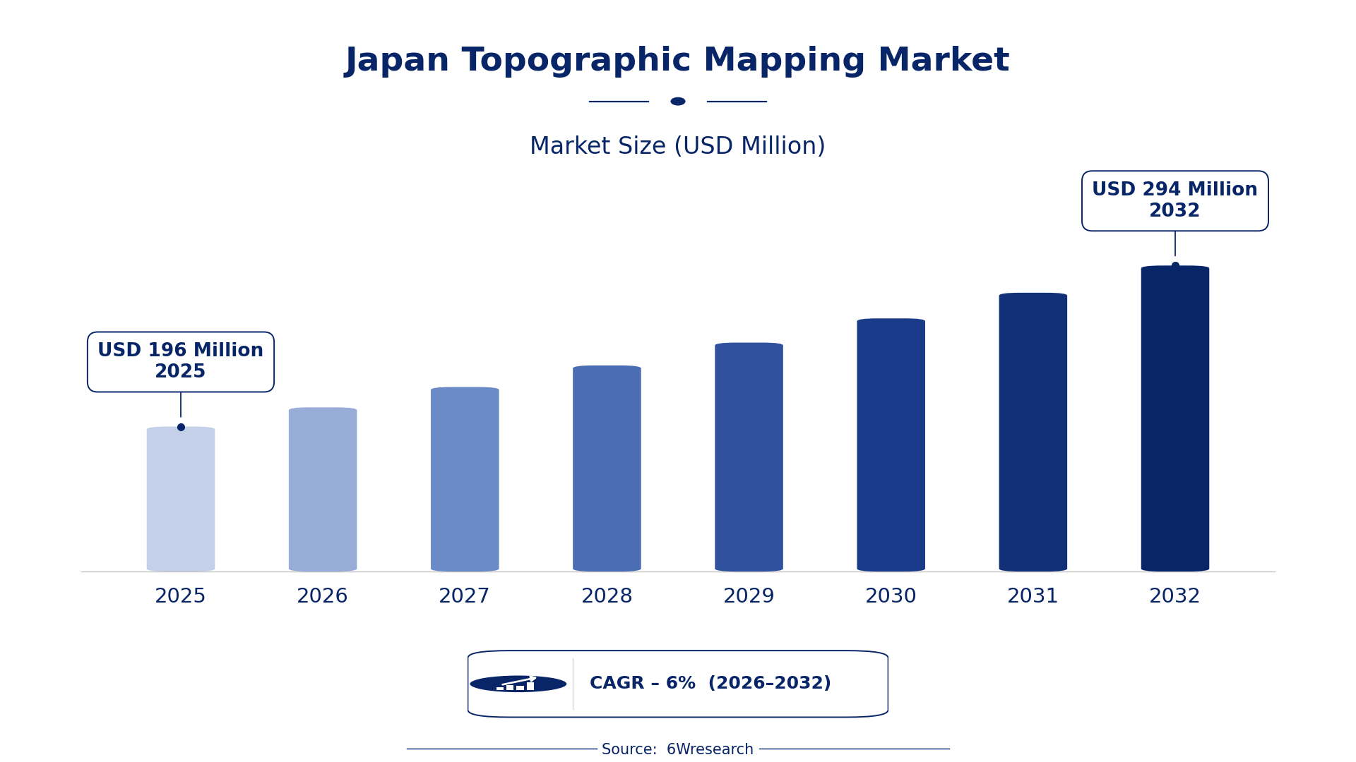
According to 6Wresearch internal database and industry insights, the Japan Topographic Mapping Market was valued at USD 196 Million in 2025 and is projected to reach USD 294 Million by 2032, growing at a CAGR of approximately 6% during 2026–2032.
Japan Topographic Mapping Market Highlights
| Report Metric | Details |
| Report Name | Japan Topographic Mapping Market (2026-2032) |
| Market Size 2025 | USD 196 Million |
| Market Size 2032 | USD 294 Million |
| Absolute Growth 2025–2032 | USD 98 Million |
| CAGR 2026–2032 | 6% |
| Peak Annual Growth | 6.8% in 2027 |
| Forecast Period | 2026–2032 |
| Historical Data | 2022–2025 |
| Base Year | 2025 |
| Leading Topographic Mapping, 2025 | Satellite DEM Mapping (36% share) |
| Leading Product Type, 2025 | DEM Generation (36% share) |
| Leading Technique, 2025 | Radar/Optical Satellite (37% share) |
| Leading Distribution Channel, 2025 | Remote Sensing Services (37% share) |
| Leading End User Industry, 2025 | Geography/Planning (36% share) |
| Fastest-Growing Topographic Mapping | Drone-Based Mapping (8.0% CAGR) |
| Fastest-Growing Product Type | UAV LIDAR Systems (8.6% CAGR) |
| Fastest-Growing Technique | LiDAR (7.8% CAGR) |
| Fastest-Growing Distribution Channel | GIS Solution Providers (8.2% CAGR) |
| Fastest-Growing End User Industry | Construction & Surveying (9.0% CAGR) |
| Growing Sector | Construction & Surveying |
| Key End Users | Civil Engineering Firms, Geography/Planning, Environmental Analysis |
Japan Topographic Mapping Market Year-wise Growth Rate and Key Drivers (2022–2032)
This graph illustrates the annual growth rates of the market from 2022 to 2032, highlighting a steady upward trajectory and projected market expansion over the forecast period.
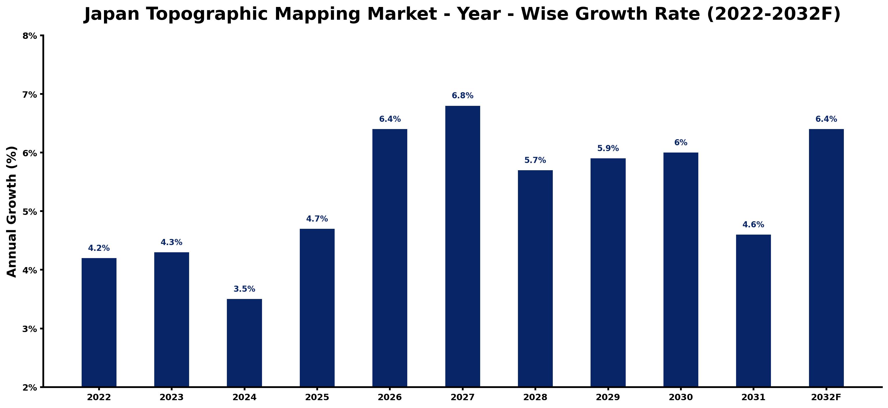
For each year, the table pairs the estimated growth rate with the leading influence on demand, showing how the drivers changed across the period.
| Year | Estimated Annual Growth (%) | Market Rationale |
| 2022 | 4.2 | The market experienced steady growth, reflecting ongoing demand for accurate mapping solutions. |
| 2023 | 4.3 | Urban development projects in major cities increased demand for topographic mapping services. |
| 2024 | 3.5 | Growth slowed slightly as some sectors adjusted to previous expansions in technology. |
| 2025 | 4.7 | The market rebounded with increased investments in infrastructure and civil engineering projects. |
| 2026 | 6.4 | Demand is expected to surge as urban planning initiatives expand, requiring detailed topographic data. |
| 2027 | 6.8 | Growth is projected to peak with heightened investments in technology and urban development projects. |
| 2028 | 5.7 | The market will see a slowdown as some projects reach completion, stabilising demand. |
| 2029 | 5.9 | Growth is expected to resume as new construction projects emerge, driving demand for services. |
| 2030 | 6.0 | Demand will continue to rise, supported by ongoing urbanisation and infrastructure needs. |
| 2031 | 4.6 | Growth is projected to slow as the market adjusts to previous high levels of investment. |
| 2032 | 6.4 | Demand is expected to increase again as new geospatial technologies are adopted. |
Note: Market size estimations and growth projections presented in this report are based on 6Wresearch's proprietary forecasting methodology, utilizing the latest available industry data, government publications, and primary research inputs.
Japan Topographic Mapping Market Synopsis
Topographic mapping creates detailed representations of the Earth's surface using technologies such as satellite imagery and aerial surveys. This mapping is vital for urban planning, environmental monitoring, and infrastructure development. The Japan Topographic Mapping Market is expanding due to the construction sector, valued at over 50 trillion yen, and the rising adoption of technologies like LiDAR. Initiatives from the Ministry of Land, Infrastructure, Transport and Tourism are stimulating demand for precise mapping solutions.
Market Dynamics Impact Analysis (2026–2032)
| Factor | Type | Impact | Primary Segment Affected |
| Increased urbanisation in metropolitan areas | Driver | High | Satellite DEM Mapping |
| Growing adoption of LiDAR technology for urban planning | Driver | High | LiDAR |
| Expansion of GIS solution providers | Opportunity | Medium | GIS Solution Providers |
| Rising demand for high-resolution drone-based mapping | Opportunity | High | Drone-Based Mapping |
| High costs associated with advanced surveying equipment | Restraint | High | Ground Survey Equipment |
| Limited access to geospatial data in rural areas | Restraint | Medium | Satellite DEM Mapping |
| Challenges in integrating new technologies with existing systems | Challenge | High | Software Tools |
| Competition among local and international mapping firms | Challenge | Medium | Remote Sensing Services |
Evaluation of Drivers in Japan Topographic Mapping Market (2026–2032)
Below are the drivers that matter most for revenue growth, with supporting evidence.
| Drivers | Primary Segment Affected | Why It Matters (Evidence) |
| Urban planning initiatives | Satellite DEM Mapping | The Tokyo metropolitan area, with a population of over 14 million, drives demand for accurate mapping to support urban development. |
| Investment in GIS technology | Software Tools | In 2022, Japan invested heavily in GIS technology for environmental monitoring, increasing demand for processing tools. |
| Adoption of UAVs for mapping | Drone-Based Mapping | The use of UAVs has surged, providing high-resolution imagery for precise mapping tasks in construction. |
| Government initiatives promoting geospatial data accessibility | Satellite DEM Mapping | The Japanese government aims to improve geospatial data accessibility by 2025, increasing demand for mapping services. |
| Technological advancements in LiDAR | UAV LIDAR Systems | LiDAR technology is increasingly adopted in urban planning projects, necessitating accurate terrain mapping. |
A wider customer base explains much of the growth, as urban planning projects in the Tokyo metropolitan area drive demand for accurate mapping solutions. In 2022, Japan invested heavily in GIS technology for environmental monitoring, increasing the need for software tools. The adoption of UAVs for mapping has surged, providing high-resolution imagery for construction projects. Technological advancements in LiDAR are increasingly adopted in urban planning, necessitating precise terrain mapping for infrastructure development. As urbanisation accelerates, the demand for accurate mapping solutions continues to rise.
Evaluation of Restraints in Japan Topographic Mapping Market
Below are the constraints most often cited by buyers and suppliers, with the segment each affects.
| Market Restraint | Primary Segment Affected | Why It Matters (Evidence) |
| High costs associated with advanced surveying equipment | Ground Survey Equipment | The construction sector, valued at over 50 trillion yen, faces challenges due to expensive surveying tools that limit project budgets. |
| Limited access to geospatial data in rural areas | Satellite DEM Mapping | Rural regions often lack the infrastructure for accurate mapping, hindering service availability. |
| Integration challenges with new technologies | Software Tools | Many firms struggle to integrate advanced mapping technologies with existing systems, delaying project timelines. |
| Dependence on skilled professionals for mapping | Remote Sensing Services | The shortage of qualified personnel in geospatial fields affects the quality and speed of services. |
| Regulatory compliance costs for mapping services | Satellite DEM Mapping | Compliance with standards like ISO 19152 increases operational costs for service providers. |
Japan Topographic Mapping Market Challenges
Japan's construction sector, valued at over 50 trillion yen, faces fierce competition among topographic mapping providers, which compresses profit margins for producers. Buyers expect faster delivery of mapping services, leading to project delays that can elevate costs for construction firms by 15%. Regulatory complexities from the National Land Agency impede project approvals, prolonging timelines for producers and affecting their ability to meet buyer expectations. Rising operational costs, particularly from integrating advanced technologies like UAVs and LiDAR, drive service prices higher, straining budgets for buyers in the construction sector.
Trends in the Japan Topographic Mapping Market
The trends below show where the Japan Topographic Mapping Market is heading.
- Rise of Drone-Based Mapping: In 2023, the adoption of drone-based mapping surged, especially in urban planning. This technology accounted for a significant share of mapping projects, enhancing data accuracy and efficiency.
- Growth of LiDAR Technology: LiDAR technology gained traction in urban planning projects across Japan. In 2023, its application in mapping rose by 15%, enabling more detailed topographical information.
- Increase in GIS Solution Providers: The emergence of GIS solution providers transformed the mapping sector, with a marked increase in demand for tailored solutions in 2023. This trend reflects the growing need for integrated data analysis.
- Focus on Environmental Monitoring: In 2023, environmental monitoring became a central focus for topographic mapping, driven by government initiatives. The Ministry of the Environment promotes mapping for ecological conservation, boosting demand for accurate data.
Investment Opportunities in the Japan Topographic Mapping Market
Where to invest in the Japan Topographic Mapping Market: the main openings are set out below.
- Demand from Construction & Surveying Sector: The construction sector, valued at over 50 trillion yen, requires precise mapping solutions. Investing in UAV-based mapping services can capture high-resolution data for ongoing projects.
- Need for Urban Planning Solutions: With urbanisation accelerating, there is a pressing need for accurate mapping. The Tokyo metropolitan government is actively seeking advanced mapping solutions to support infrastructure development.
- Geospatial Data Accessibility Initiatives: The government's target to improve geospatial data accessibility by 2025 presents opportunities for companies offering mapping solutions. Collaborating with local authorities can facilitate entry into this market.
- Investment in GIS Technology: The growing demand for GIS technology in environmental monitoring creates opportunities for software developers. Partnering with government agencies can improve market entry and visibility.
Government Initiatives in the Japan Topographic Mapping Market
The Building Energy Efficiency Act, amended in 2022, mandates that all new buildings meet energy standards, indirectly influencing the need for accurate topographic mapping to assess land use. Additionally, the Digital Agency, established in 2021, promotes the use of digital technologies, including geospatial data, improving mapping services across Japan.
In 2023, the Ministry of Land, Infrastructure, Transport and Tourism launched a geospatial data initiative, allocating substantial funding to improve mapping services. The National Land Agency oversees regulations and standards for topographic mapping, ensuring compliance and quality in projects.
Future Insight of the Japan Topographic Mapping Market
A policy-driven shift will prioritise improved geospatial data accessibility, prompting suppliers to adapt to new standards. The Ministry of Land, Infrastructure, Transport and Tourism's geospatial data initiative will drive technological advancements, enabling more precise mapping solutions. Urban planners will embrace GIS technology, reflecting substantial investments in recent years. By 2032, the annual Geospatial Information Conference will showcase ongoing innovations, fostering collaboration among stakeholders and strengthening the overall mapping framework.
Market Segmentation Analysis
Japan Topographic Mapping Market report covers a detailed analysis of the following market segments:
By Topographic Mapping – Satellite DEM Mapping Leads, Drone-Based Mapping Expected to Grow Fastest
According to Saurav Kr Singh, Senior Research Analyst at 6Wresearch, in 2025, Satellite DEM Mapping led the topographic mapping split with a 36% share. Satellite DEM Mapping holds the largest share as it provides essential elevation data crucial for urban planning and infrastructure development. The Tokyo metropolitan area exemplifies this reliance, where accurate topographic data is vital for ongoing projects. Drone-Based Mapping is projected to grow fastest, at a CAGR of 8.0% during 2026–2032. Drone-Based Mapping is experiencing rapid growth due to its ability to offer high-resolution imagery that significantly improves mapping precision. The increasing adoption of UAV technology for urban planning projects is a key factor in this growth. Suppliers should focus on integrating advanced drone technologies to meet the rising demand for high-resolution mapping.
By Product Type – DEM Generation Leads, UAV LIDAR Systems Expected to Grow Fastest
With 36% of product type revenue in 2025, DEM Generation was the largest category. DEM Generation is the leading segment as it is key for creating digital elevation models that are essential for effective planning and development. The construction sector, valued at over 50 trillion yen, heavily utilises these models for various projects. The quickest growth will come from UAV LIDAR Systems, forecast to expand at a CAGR of 8.6% between 2026 and 2032. UAV LIDAR Systems are growing quickly due to their capability for high-accuracy terrain mapping, which is increasingly required in complex construction projects. This need for precision is driving investment in UAV technologies. Buyers will benefit from investing in advanced DEM generation technologies to ensure accurate project planning.
By Technique – Radar/Optical Satellite Leads, LiDAR Expected to Grow Fastest
The largest technique category in 2025 was Radar/Optical Satellite, at 37% of revenue. Radar/Optical Satellite techniques dominate the market as they are instrumental in capturing large-scale geographical data necessary for various applications. This method is particularly valuable in Japan's densely populated regions, where comprehensive data is essential. LiDAR is set to record the highest CAGR in this split, 7.8% over 2026–2032. LiDAR is the fastest-growing technique because it provides detailed topographical information through laser scanning, which is increasingly vital for modern mapping needs. The growing use of LiDAR in urban planning is propelling its rapid expansion. Suppliers should consider expanding their offerings in LiDAR technology to capitalise on its growing demand.
By Distribution Channel – Remote Sensing Services Lead, GIS Solution Providers Expected to Grow Fastest
Remote Sensing Services took 37% of distribution channel revenue in 2025, more than any other category. Remote Sensing Services lead the distribution channel segment as they offer comprehensive data collection that supports various industries, including government and construction. These services play a crucial role in disaster management and urban planning efforts. Over 2026–2032, GIS Solution Providers are expected to post the fastest growth, at a CAGR of 8.2%. GIS Solution Providers are rapidly growing as they deliver customised mapping solutions that cater to specific end-user requirements. The rising demand for tailored GIS applications is a significant driver of this growth. Suppliers must enhance their GIS solutions to address the increasing demand for customised mapping services.
By End User Industry – Geography/Planning Leads, Construction & Surveying Expected to Grow Fastest
Geography/Planning accounted for 36% of the market by end user industry in 2025. Geography/Planning is the largest end-user industry as it utilises mapping for urban and regional development, which is critical in Japan's densely populated areas. The ongoing urbanisation in cities like Tokyo highlights the importance of precise mapping. Construction & Surveying is projected to grow fastest, at a CAGR of 9.0% during 2026–2032. Construction & Surveying is the fastest-growing industry as it relies heavily on accurate mapping for project execution, particularly in large-scale developments. The robust construction sector is a major contributor to this growth. Buyers in the construction sector should prioritise accurate mapping solutions to ensure successful project outcomes.
Key Attractiveness of the Report
- 10 Years of Market Numbers
- Historical Data Starting from 2022 to 2025
- Base Year 2025
- Forecast Data until 2032
- Key Performance Indicators Impacting the Market
- Major Upcoming Developments and Projects
Key Highlights of the Report:
- Japan Topographic Mapping Market Outlook
- Market Size of Japan Topographic Mapping Market, 2025
- Forecast of Japan Topographic Mapping Market, 2032
- Historical Data and Forecast of Japan Topographic Mapping Revenues & Volume for the Period 2022-2032F
- Japan Topographic Mapping Market Trend Evolution
- Japan Topographic Mapping Market Drivers and Challenges
- Japan Topographic Mapping Price Trends
- Japan Topographic Mapping Porter's Five Forces
- Japan Topographic Mapping Industry Life Cycle
- Historical Data and Forecast of Japan Topographic Mapping Market Revenues & Volume By Topographic Mapping for the Period 2022-2032F
- Historical Data and Forecast of Japan Topographic Mapping Market Revenues & Volume By Satellite DEM Mapping for the Period 2022-2032F
- Historical Data and Forecast of Japan Topographic Mapping Market Revenues & Volume By Drone-Based Mapping for the Period 2022-2032F
- Historical Data and Forecast of Japan Topographic Mapping Market Revenues & Volume By Ground Survey Equipment for the Period 2022-2032F
- Historical Data and Forecast of Japan Topographic Mapping Market Revenues & Volume By Software Tools for the Period 2022-2032F
- Historical Data and Forecast of Japan Topographic Mapping Market Revenues & Volume By Product Type for the Period 2022-2032F
- Historical Data and Forecast of Japan Topographic Mapping Market Revenues & Volume By DEM Generation for the Period 2022-2032F
- Historical Data and Forecast of Japan Topographic Mapping Market Revenues & Volume By UAV LIDAR Systems for the Period 2022-2032F
- Historical Data and Forecast of Japan Topographic Mapping Market Revenues & Volume By Total Stations for the Period 2022-2032F
- Historical Data and Forecast of Japan Topographic Mapping Market Revenues & Volume By Mapping Software for the Period 2022-2032F
- Historical Data and Forecast of Japan Topographic Mapping Market Revenues & Volume By Technique for the Period 2022-2032F
- Historical Data and Forecast of Japan Topographic Mapping Market Revenues & Volume By Radar/Optical Satellite for the Period 2022-2032F
- Historical Data and Forecast of Japan Topographic Mapping Market Revenues & Volume By LiDAR, Photogrammetry for the Period 2022-2032F
- Historical Data and Forecast of Japan Topographic Mapping Market Revenues & Volume By GNSS + Laser for the Period 2022-2032F
- Historical Data and Forecast of Japan Topographic Mapping Market Revenues & Volume By GIS Platforms for the Period 2022-2032F
- Historical Data and Forecast of Japan Topographic Mapping Market Revenues & Volume By Distribution Channel for the Period 2022-2032F
- Historical Data and Forecast of Japan Topographic Mapping Market Revenues & Volume By Remote Sensing Services for the Period 2022-2032F
- Historical Data and Forecast of Japan Topographic Mapping Market Revenues & Volume By GIS Solution Providers for the Period 2022-2032F
- Historical Data and Forecast of Japan Topographic Mapping Market Revenues & Volume By Geodetic Equip Suppliers for the Period 2022-2032F
- Historical Data and Forecast of Japan Topographic Mapping Market Revenues & Volume By SaaS Vendors for the Period 2022-2032F
- Historical Data and Forecast of Japan Topographic Mapping Market Revenues & Volume By End User Industry for the Period 2022-2032F
- Historical Data and Forecast of Japan Topographic Mapping Market Revenues & Volume By Geography/Planning for the Period 2022-2032F
- Historical Data and Forecast of Japan Topographic Mapping Market Revenues & Volume By Construction & Surveying for the Period 2022-2032F
- Historical Data and Forecast of Japan Topographic Mapping Market Revenues & Volume By Civil Engineering Firms for the Period 2022-2032F
- Historical Data and Forecast of Japan Topographic Mapping Market Revenues & Volume By Environmental Analysis for the Period 2022-2032F
- Japan Topographic Mapping Import Export Trade Statistics
- Market Opportunity Assessment By Topographic Mapping
- Market Opportunity Assessment By Product Type
- Market Opportunity Assessment By Technique
- Market Opportunity Assessment By Distribution Channel
- Market Opportunity Assessment By End User Industry
- Japan Topographic Mapping Top Companies Market Share
- Japan Topographic Mapping Competitive Benchmarking By Technical and Operational Parameters
- Japan Topographic Mapping Company Profiles
- Japan Topographic Mapping Key Strategic Recommendations
Market Covered
The following segment groups are covered in the report.
By Topographic Mapping
- Satellite DEM Mapping
- Drone-Based Mapping
- Ground Survey Equipment
- Software Tools
By Product Type
- DEM Generation
- UAV LIDAR Systems
- Total Stations
- Mapping Software
By Technique
- Radar/Optical Satellite
- LiDAR
- Photogrammetry
- GNSS + Laser
- GIS Platforms
By Distribution Channel
- Remote Sensing Services
- GIS Solution Providers
- Geodetic Equip Suppliers
- SaaS Vendors
By End User Industry
- Geography/Planning
- Construction & Surveying
- Civil Engineering Firms
- Environmental Analysis































