China Satellite Imagery Market Size & Growth Rate
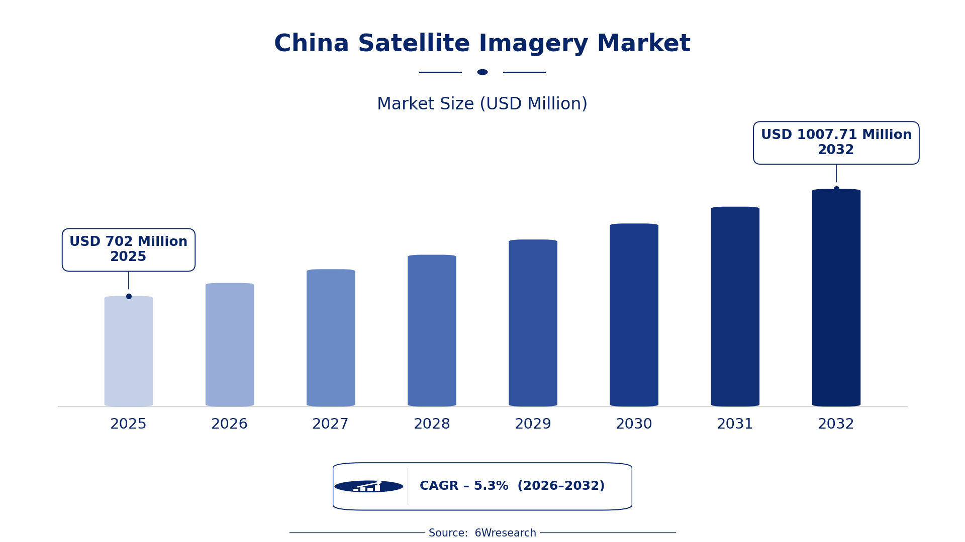
According to 6Wresearch internal database and industry insights, the China Satellite Imagery Market was valued at USD 702.0 million in 2025 and is projected to reach USD 1,007.71 million by 2032, growing at a CAGR of approximately 5.3% during 2026–2032.
China Satellite Imagery Market Highlights
| Report Metric | Details |
| Report Name | China Satellite Imagery Market |
| Market Size 2025 | USD 702.0 million |
| Market Size 2032 | USD 1,007.71 million |
| Absolute Growth 2025–2032 | USD 305.71 million |
| CAGR 2026–2032 | 5.3% |
| Peak Annual Growth | 7.3% in 2031 |
| Forecast Period | 2026–2032 |
| Historical Data | 2022–2025 |
| Base Year | 2025 |
| Leading Image Type, 2025 | Panchromatic (46% share) |
| Leading Spectral Band, 2025 | Visible Light (51% share) |
| Leading Resolution Type, 2025 | Ultra-High Resolution (42% share) |
| Leading End User, 2025 | Defense Intelligence (46% share) |
| Fastest-Growing Image Type | Multispectral (7.3% CAGR) |
| Fastest-Growing Spectral Band | Infrared/Visible (6.8% CAGR) |
| Fastest-Growing Resolution Type | High-Resolution (6.7% CAGR) |
| Fastest-Growing End User | Environmental Agencies (7.1% CAGR) |
| Growing Sector | Environmental Monitoring |
| Key End Users | Environmental Agencies, Urban Planners, Defense Intelligence, Research Institutes |
China Satellite Imagery Market Year-wise Growth Rate and Key Drivers (2022–2032)
This graph illustrates the annual growth rates of the market from 2022 to 2032, highlighting a steady upward trajectory and projected market expansion over the forecast period.
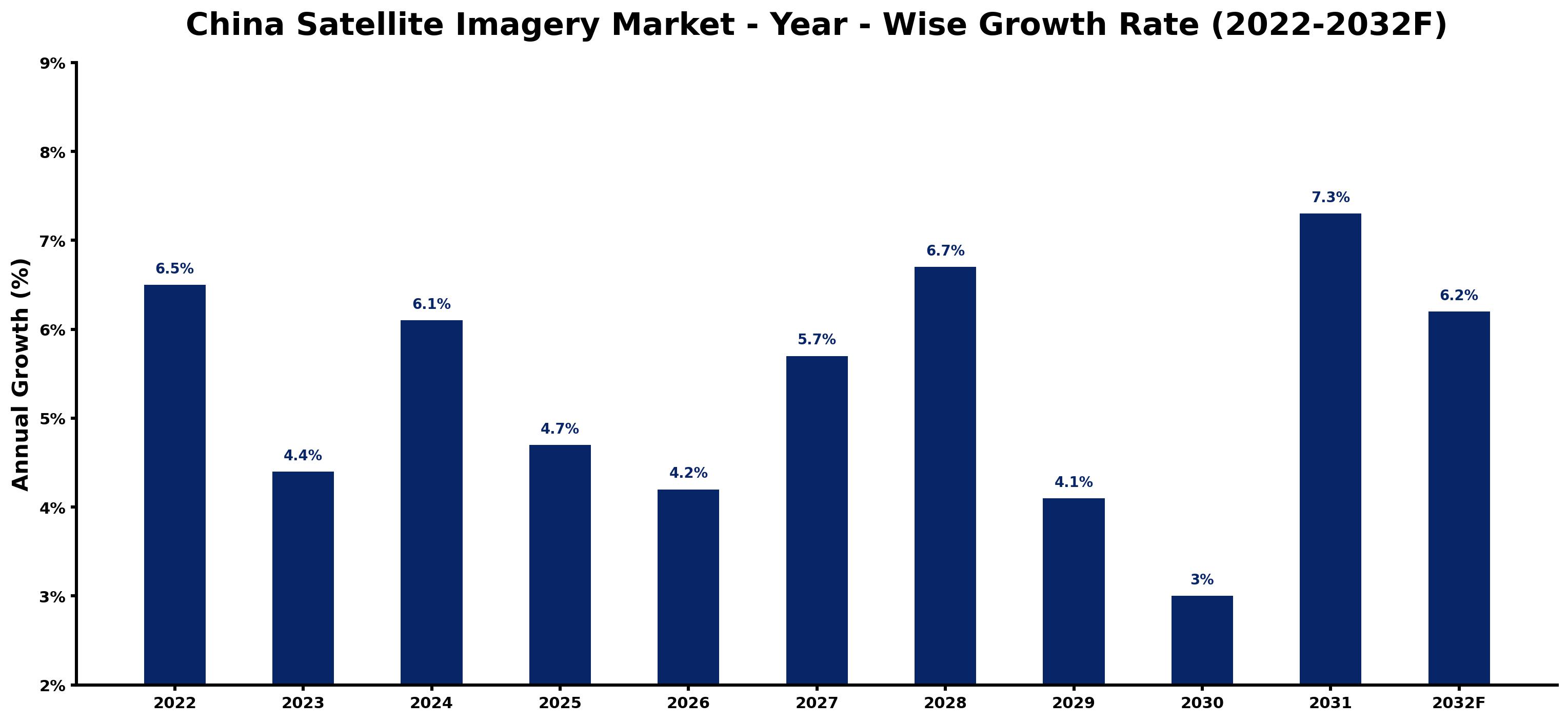
The table below sets out the estimated growth rate for each year and the main factor behind it.
| Year | Estimated Annual Growth (%) | Market Rationale |
| 2022 | 6.5 | The market experienced strong growth due to numerous satellite launches for Earth observation. |
| 2023 | 4.4 | Growth slowed as investment in satellite technology faced temporary adjustments from previous high levels. |
| 2024 | 6.1 | The market rebounded with increased demand for high-resolution satellite imagery applications in urban planning. |
| 2025 | 4.7 | Growth slowed again as market conditions began to normalise after rapid expansion in prior years. |
| 2026 | 4.2 | A further slowdown is expected as the Remote Sensing Data Sharing Program improves access to satellite imagery for various sectors. |
| 2027 | 5.7 | Demand is projected to increase as environmental agencies expand their use of satellite data for monitoring air quality. |
| 2028 | 6.7 | Growth is expected to accelerate with rising investments in urban planning and infrastructure development initiatives. |
| 2029 | 4.1 | The market is projected to experience a slowdown as competition intensifies among satellite service providers. |
| 2030 | 3.0 | Growth is expected to slow further as buyers adjust to market conditions and demand patterns for satellite imagery. |
| 2031 | 7.3 | A surge in demand will be driven by enhanced satellite capabilities and government support for Earth observation initiatives. |
| 2032 | 6.2 | The market is projected to continue growing as applications in disaster management expand through improved satellite data. |
Note: Market size estimations and growth projections presented in this report are based on 6Wresearch's proprietary forecasting methodology, utilizing the latest available industry data, government publications, and primary research inputs.
China Satellite Imagery Market Synopsis
Satellite Imagery in China includes technology that captures images of the Earth's surface using satellites equipped with sensors. This imagery serves crucial purposes in environmental monitoring, urban planning, and defence applications. The China Satellite Imagery Market is growing due to increasing demand from environmental agencies and urban planners, along with investments in satellite technology. In 2022, China launched 40 new satellites, boosting its Earth observation capabilities.
Market Dynamics Impact Analysis (2026–2032)
| Factor | Type | Impact | Primary Segment Affected |
| Rising demand for environmental monitoring applications drives the need for satellite imagery. | Driver | High | Environmental Agencies |
| Increased urban planning initiatives require high-resolution satellite data for development. | Driver | High | High-Resolution |
| The growing need for satellite data in pollution tracking presents investment opportunities. | Opportunity | High | Panchromatic |
| Investment in satellite technology is increasing due to government support for infrastructure. | Opportunity | High | Panchromatic |
| High operational costs associated with satellite launches can limit market expansion. | Restraint | High | Panchromatic |
| Data accuracy issues can hinder the effectiveness of satellite imagery applications. | Restraint | Medium | Panchromatic |
| The market faces challenges related to regulatory compliance and data privacy. | Challenge | High | Panchromatic |
| Limited access to satellite data for smaller firms restricts their operational capabilities. | Challenge | Medium | Panchromatic |
Evaluation of Drivers in China Satellite Imagery Market (2026–2032)
The table below links each growth driver to the segment it affects and the evidence for it.
| Drivers | Primary Segment Affected | Why It Matters (Evidence) |
| Increased satellite launches for Earth observation. | Panchromatic | In 2022, China launched 40 new satellites, boosting demand for high-resolution imagery across various sectors. |
| Growing applications in urban planning. | Multispectral | Panchromatic imagery is widely used in urban planning across major cities, increasing demand for high-quality satellite data. |
| Rising environmental monitoring needs. | Radar Imagery | Environmental agencies utilize satellite imagery for air quality assessment, driving demand for accurate data solutions. |
| Support from government initiatives. | Defense Intelligence | The National Defense Authorization Act includes provisions for satellite imagery in defense strategies, enhancing procurement activities. |
| Growing research initiatives using satellite data. | Research Institutes | Research institutes in China publish over 200 papers annually using satellite data, increasing demand for reliable imagery. |
Growth in the Satellite Imagery market in China comes from increasing end-use demand for high-resolution imaging and a responsive supply chain. In 2022, the launch of 40 new satellites expanded Earth observation capabilities, leading to a surge in applications across urban planning and environmental monitoring. The average resolution of commercial satellite imagery is now 0.5 meters, which improves its utility for detailed mapping.
Evaluation of Restraints in China Satellite Imagery Market
The table below lists the restraints and the evidence behind each.
| Market Restraint | Primary Segment Affected | Why It Matters (Evidence) |
| High operational costs associated with satellite launches. | Panchromatic | The costs of launching satellites can limit the frequency of new satellite deployments, impacting market growth. |
| Data accuracy issues can hinder applications. | Multispectral | Inconsistent data quality affects the reliability of satellite imagery for decision-making, limiting its use in critical applications. |
| Regulatory compliance challenges restrict market access. | Radar Imagery | Stringent regulations may delay satellite data usage approvals for new projects, affecting service delivery timelines. |
| Limited access to satellite data for smaller firms. | Research Institutes | Smaller firms often struggle to afford high-quality satellite data, limiting their research capabilities and output quality. |
| Competition among satellite service providers can drive prices down. | Defense Intelligence | Intense competition may lead to reduced profit margins for satellite service providers, affecting their investment capacity. |
China Satellite Imagery Market Challenges
The China Satellite Imagery Market encounters several practical issues, with a skills shortage being a primary concern. The rapid growth of satellite technology has outstripped the availability of qualified professionals, leading to project delays and a 20% increase in costs for producers. Competition among domestic firms is intense, resulting in price wars that squeeze margins for suppliers and limit their capacity to invest in advancements. The technology gap in satellite data processing restricts the quality of imagery available, impacting buyers who require high-resolution data for critical applications. Supply chain disruptions are delaying the launch of new satellites, affecting the availability of imagery for various sectors and hindering timely environmental monitoring efforts.
Trends in the China Satellite Imagery Market
Below mentioned are some of the trends shaping the China Satellite Imagery Market growth.
- Shift to High-Resolution Imagery: Environmental agencies are increasingly adopting high-resolution satellite imagery for monitoring. In 2022, the average resolution reached 0.5 meters, improving data accuracy for compliance assessments.
- Transition to Improved Data Sharing Initiatives: The Remote Sensing Data Sharing Program initiated in 2022 aims to improve access to satellite imagery. This initiative supports public and private sectors, facilitating better data utilisation across various applications.
- Emergence of Satellite-Based Environmental Monitoring: The Satellite-Based Environmental Monitoring Program launched in 2023 utilises satellite data for tracking pollution. This program is expected to enhance compliance across various sectors, improving environmental management.
- Growing Demand for Urban Planning Applications: Urban planners are increasingly relying on satellite imagery for development projects. In 2022, significant investments were made in satellite technology to support urban planning initiatives, driving demand for high-resolution data.
Investment Opportunities in the China Satellite Imagery Market
Below are the investment opportunities with the strongest case in the China Satellite Imagery Market.
- Investment in Satellite Technology Development: With China investing 5 billion yuan in satellite technology development, there is an opportunity for firms to supply advanced satellite components. Environmental agencies are key buyers, seeking improved satellite capabilities.
- Supply of High-Resolution Satellite Imagery: The demand for high-resolution satellite imagery is rising, particularly among urban planners. Investing in high-resolution imaging services can meet this growing need effectively and enhance project outcomes.
- Partnerships for Data Sharing Programs: Now is an ideal time to engage in partnerships for data sharing initiatives. The Remote Sensing Data Sharing Program offers a pathway for collaboration with public and private sectors, enhancing data accessibility.
- Expansion of Environmental Monitoring Services: The Satellite-Based Environmental Monitoring Program creates opportunities for firms to supply satellite data services. Environmental agencies are actively seeking reliable data for pollution tracking and compliance.
Government Initiatives in the China Satellite Imagery Market
The National Space Development Plan 2021-2025, issued by the China National Space Administration, aims to improve satellite imaging capabilities with a focus on environmental monitoring and urban planning. This plan outlines the government's commitment to advancing satellite technology and data quality. The National Standard for Remote Sensing Data Quality was established in 2021 to ensure data accuracy and reliability, further supporting the industry's growth. Additionally, the Remote Sensing Data Sharing Program launched in 2022 aims to improve access to satellite imagery for both public and private sectors, facilitating broader application of satellite data across various industries.
Environmental agencies benefit from the Remote Sensing Data Sharing Program, which provides access to essential satellite imagery for monitoring air quality and environmental compliance. The Ministry of Ecology and Environment initiated the Satellite-Based Environmental Monitoring Program in 2023, utilising satellite data for pollution tracking. The National Remote Sensing Center of China has allocated 1 billion yuan for satellite data processing and application development in 2023, supporting various sectors in utilising satellite imagery for their needs. These initiatives improve the capacity of agencies to effectively utilise satellite data for monitoring and compliance.
Future Insight of the China Satellite Imagery Market
The China Satellite Imagery Market is poised for significant evolution by 2032, with government initiatives and technological advancements shaping its trajectory. The National Space Development Plan aims to improve satellite capabilities, which will enhance data quality and resolution. By 2025, the China National Space Administration plans to operate over 100 Earth observation satellites, increasing data availability. The Ministry of Ecology and Environment's satellite-based monitoring program will expand applications in environmental assessment, creating new opportunities for buyers in urban planning and disaster response.
Market Segmentation Analysis
The report offers a comprehensive study of the following market segments and their leading categories in the market.
By Image Type – Panchromatic Dominated, Multispectral Expected to Grow Fastest
According to Shubham Padhi, Research Analyst at 6Wresearch, Panchromatic accounted for a 46% market share by image type in 2025. Panchromatic imagery holds the largest share due to its critical role in high-resolution imaging applications, particularly in urban planning across major cities in China. Its ability to provide detailed images makes it indispensable for various sectors relying on precise data. Over 2026–2032, Multispectral is expected to post the fastest growth, at a CAGR of 7.3%. The multispectral segment is experiencing rapid growth, driven by its essential applications in agricultural monitoring and environmental assessments. The increasing emphasis on sustainable practices and resource management is significantly boosting the demand for multispectral imagery. Suppliers should prioritise the development of multispectral imaging solutions to cater to the rising needs of environmental monitoring and agricultural sectors.
By Spectral Band – Visible Light Dominated, Infrared/Visible Expected to Grow Fastest
In 2025, Visible Light led the spectral band split with a 51% share. Visible light imagery commands the largest market share as it is widely used in standard imaging applications across diverse sectors, including urban planning. Its effectiveness in capturing images under normal lighting conditions reinforces its leading position in the market. Infrared/Visible is projected to grow fastest, at a CAGR of 6.8% during 2026–2032. Infrared/Visible imagery is the fastest-growing segment, primarily due to its applications in environmental studies and thermal imaging. The growing awareness of climate change and the need for effective resource management are accelerating its adoption. Suppliers should consider investing in infrared/visible technology to capitalise on the increasing interest in environmental monitoring and related applications.
By Resolution Type – Ultra-High Resolution Dominated, High-Resolution Expected to Grow Fastest
The largest resolution type category in 2025 was Ultra-High Resolution, with a 42% share of total revenue. Ultra-high resolution imagery leads the market share, largely due to its necessity for precision applications in defence and security. The demand for detailed surveillance and reconnaissance operations significantly drives its widespread adoption across various sectors. High-Resolution is set to record the highest CAGR in this split, 6.7% over 2026–2032. High-resolution imagery is witnessing rapid growth, mainly because of its critical role in detailed mapping and analysis required for urban planning. As urbanisation accelerates, the need for high-resolution data becomes increasingly vital for effective development. This indicates that suppliers must enhance their high-resolution offerings to meet the growing demand from urban planners and developers seeking detailed insights.
By End User – Defense Intelligence Dominated, Environmental Agencies Expected to Grow Fastest
Defense Intelligence held a 46% share of the China Satellite Imagery Market by end user in 2025. Defense intelligence captures the largest market share as it is essential for national security and strategic planning. The ongoing investments in defence capabilities by the government ensure a steady demand for satellite imagery in this sector. The quickest growth will come from Environmental Agencies, forecast to expand at a CAGR of 7.1% between 2026 and 2032. Environmental agencies are the fastest-growing end user, driven by their need for satellite imagery for monitoring and compliance purposes. The recent initiatives focusing on environmental sustainability are accelerating this growth. This trend highlights the opportunity for suppliers to tailor their offerings to meet the specific needs of environmental agencies.
Key Attractiveness of the Report
- 10 Years of Market Numbers
- Historical Data Starting from 2022 to 2025
- Base Year 2025
- Forecast Data until 2032
- Key Performance Indicators Impacting the Market
- Major Upcoming Developments and Projects
Key Highlights of the Report:
- China Satellite Imagery Market Outlook
- Market Size of China Satellite Imagery Market, 2025
- Forecast of China Satellite Imagery Market, 2032
- Historical Data and Forecast of China Satellite Imagery Revenues & Volume for the Period 2022 - 2032F
- China Satellite Imagery Market Trend Evolution
- China Satellite Imagery Market Drivers and Challenges
- China Satellite Imagery Price Trends
- China Satellite Imagery Porter's Five Forces
- China Satellite Imagery Industry Life Cycle
- Historical Data and Forecast of China Satellite Imagery Market Revenues & Volume By Image Type for the Period 2022 - 2032F
- Historical Data and Forecast of China Satellite Imagery Market Revenues & Volume By Panchromatic for the Period 2022 - 2032F
- Historical Data and Forecast of China Satellite Imagery Market Revenues & Volume By Multispectral for the Period 2022 - 2032F
- Historical Data and Forecast of China Satellite Imagery Market Revenues & Volume By Hyperspectral for the Period 2022 - 2032F
- Historical Data and Forecast of China Satellite Imagery Market Revenues & Volume By Radar Imagery for the Period 2022 - 2032F
- Historical Data and Forecast of China Satellite Imagery Market Revenues & Volume By Spectral Band for the Period 2022 - 2032F
- Historical Data and Forecast of China Satellite Imagery Market Revenues & Volume By Visible Light for the Period 2022 - 2032F
- Historical Data and Forecast of China Satellite Imagery Market Revenues & Volume By Infrared/Visible for the Period 2022 - 2032F
- Historical Data and Forecast of China Satellite Imagery Market Revenues & Volume By Wide Band for the Period 2022 - 2032F
- Historical Data and Forecast of China Satellite Imagery Market Revenues & Volume By Microwave for the Period 2022 - 2032F
- Historical Data and Forecast of China Satellite Imagery Market Revenues & Volume By Resolution Type for the Period 2022 - 2032F
- Historical Data and Forecast of China Satellite Imagery Market Revenues & Volume By High-Resolution for the Period 2022 - 2032F
- Historical Data and Forecast of China Satellite Imagery Market Revenues & Volume By Medium Resolution for the Period 2022 - 2032F
- Historical Data and Forecast of China Satellite Imagery Market Revenues & Volume By Ultra-High Resolution for the Period 2022 - 2032F
- Historical Data and Forecast of China Satellite Imagery Market Revenues & Volume By Synthetic Aperture for the Period 2022 - 2032F
- Historical Data and Forecast of China Satellite Imagery Market Revenues & Volume By End User for the Period 2022 - 2032F
- Historical Data and Forecast of China Satellite Imagery Market Revenues & Volume By Mapping Firms for the Period 2022 - 2032F
- Historical Data and Forecast of China Satellite Imagery Market Revenues & Volume By Environmental Agencies for the Period 2022 - 2032F
- Historical Data and Forecast of China Satellite Imagery Market Revenues & Volume By Research Institutes for the Period 2022 - 2032F
- Historical Data and Forecast of China Satellite Imagery Market Revenues & Volume By Defense Intelligence for the Period 2022 - 2032F
- China Satellite Imagery Import Export Trade Statistics
- Market Opportunity Assessment By Image Type
- Market Opportunity Assessment By Spectral Band
- Market Opportunity Assessment By Resolution Type
- Market Opportunity Assessment By End User
- China Satellite Imagery Top Companies Market Share
- China Satellite Imagery Competitive Benchmarking By Technical and Operational Parameters
- China Satellite Imagery Company Profiles
- China Satellite Imagery Key Strategic Recommendations
Market Covered
The report offers an extensive study of the following market segments.
By Image Type
- Panchromatic
- Multispectral
- Hyperspectral
- Radar Imagery
By Spectral Band
- Visible Light
- Infrared/Visible
- Wide Band
- Microwave
By Resolution Type
- High-Resolution
- Medium Resolution
- Ultra-High Resolution
- Synthetic Aperture
By End User
- Mapping Firms
- Environmental Agencies
- Research Institutes
- Defense Intelligence































