India Remote Sensing Data Services Market Size & Growth Rate
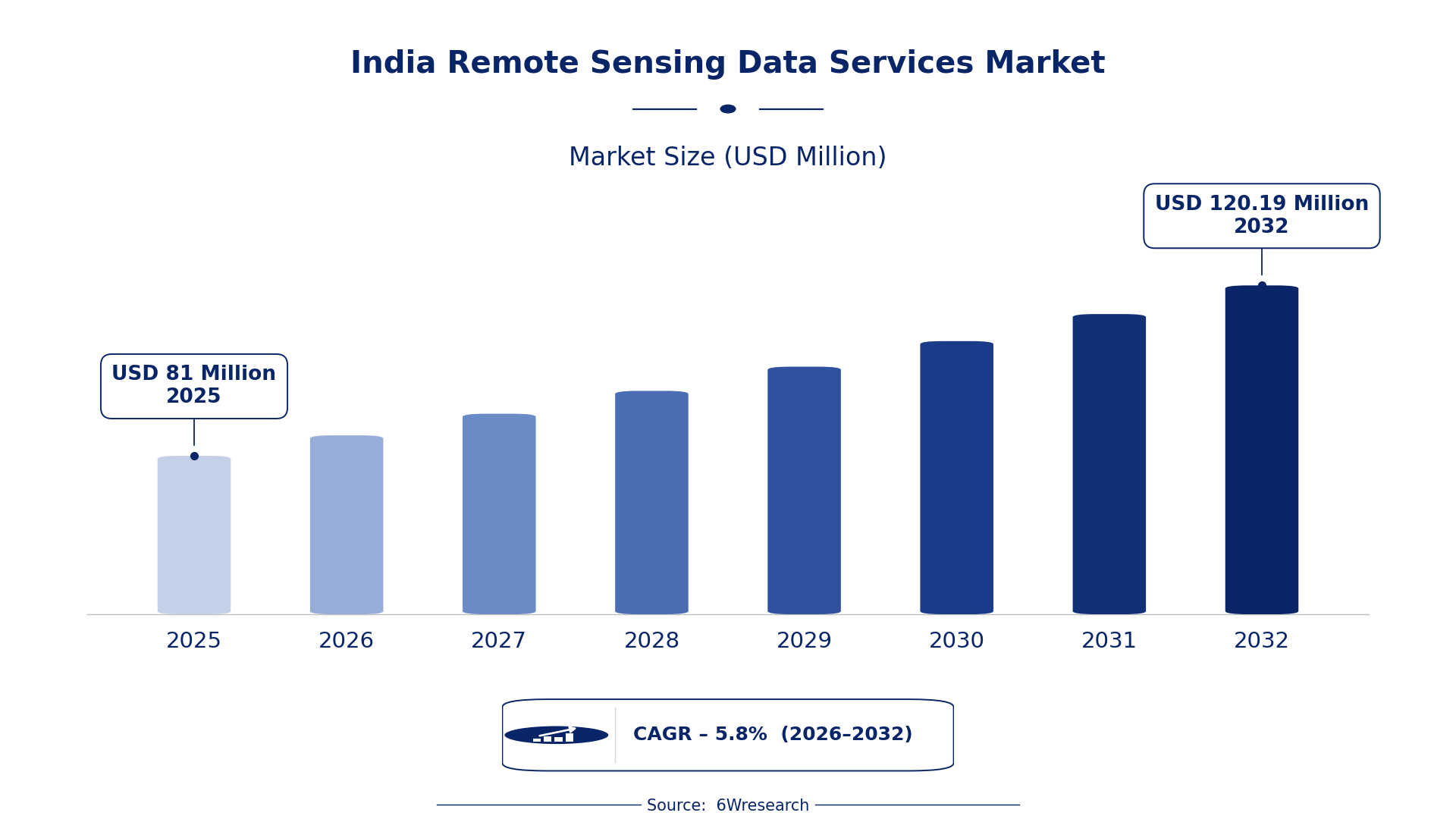
According to 6Wresearch internal database and industry insights, the India Remote Sensing Data Services Market was valued at USD 81.0 million in 2025 and is projected to reach USD 120.19 million by 2032, growing at a CAGR of approximately 5.8% during 2026–2032.
India Remote Sensing Data Services Market Highlights
| Report Metric | Details |
| Report Name | India Remote Sensing Data Services Market |
| Market Size 2025 | USD 81.0 million |
| Market Size 2032 | USD 120.19 million |
| Absolute Growth 2025–2032 | USD 39.19 million |
| CAGR 2026–2032 | 5.8% |
| Peak Annual Growth | 8.1% in 2032 |
| Forecast Period | 2026–2032 |
| Historical Data | 2022–2025 |
| Base Year | 2025 |
| Leading Data Type, 2025 | Satellite Imagery (45% share) |
| Leading Sensor Platform, 2025 | Optical/Radar (35% share) |
| Leading Delivery Method, 2025 | Cloud API (54% share) |
| Leading End User, 2025 | Energy Utilities (43% share) |
| Fastest-Growing Data Type | Drone Mapping (7.8% CAGR) |
| Fastest-Growing Sensor Platform | LiDAR/Multispectral (8.1% CAGR) |
| Fastest-Growing End User | Renewable Energy Operators (8.5% CAGR) |
| Growing Sector | Energy Utilities |
| Key End Users | Government agencies, Research institutions, Private sector companies |
India Remote Sensing Data Services Market Year-wise Growth Rate and Key Drivers (2022–2032)
This graph illustrates the annual growth rates of the market from 2022 to 2032, highlighting a steady upward trajectory and projected market expansion over the forecast period.
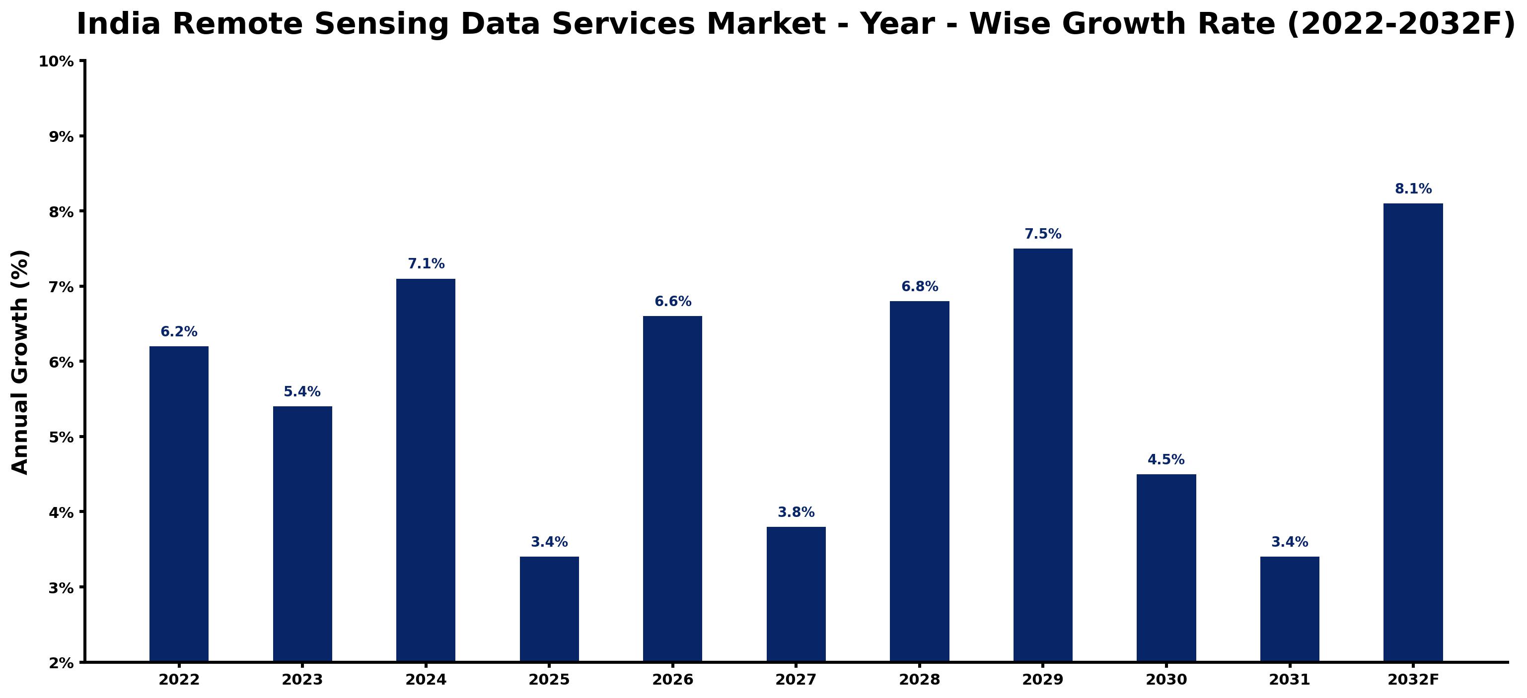
Year by year, the estimates below pair each growth rate with the development that shaped it.
| Year | Estimated Annual Growth (%) | Market Rationale |
| 2022 | 6.2 | The market showed steady growth due to increased adoption of remote sensing technologies. |
| 2023 | 5.4 | Growth slowed as urban planning projects faced delays in major cities. |
| 2024 | 7.1 | A surge in demand for satellite imagery boosted growth this year. |
| 2025 | 3.4 | Growth slowed again as budget constraints affected government spending. |
| 2026 | 6.6 | An increase in drone mapping adoption revitalised market growth. |
| 2027 | 3.8 | Growth slowed as competition intensified among service providers. |
| 2028 | 6.8 | Demand for LiDAR technology drove faster growth this year. |
| 2029 | 7.5 | A rising need for environmental monitoring services accelerated growth. |
| 2030 | 4.5 | Growth slowed as the market adjusted to new technological standards. |
| 2031 | 3.4 | Demand for remote sensing solutions stabilised as buyers sought cost-effective options. |
| 2032 | 8.1 | The market peaked with strong demand from renewable energy operators. |
Note: Market size estimations and growth projections presented in this report are based on 6Wresearch's proprietary forecasting methodology, utilizing the latest available industry data, government publications, and primary research inputs.
India Remote Sensing Data Services Market Synopsis
Remote Sensing Data Services in India encompass the acquisition and analysis of data from satellites, drones, and ground sensors for effective resource management and environmental monitoring. These services are vital for agriculture, urban planning, and disaster management. The India Remote Sensing Data Services Market is expanding due to increasing demand from government agencies and private sector companies. The National Remote Sensing Policy launched in 2021 improves data accessibility, further propelling market growth. The ongoing development of satellite technology infrastructure supports the continuous utilisation of these services.
Market Dynamics Impact Analysis (2026–2032)
| Factor | Type | Impact | Primary Segment Affected |
| Growing adoption of satellite imagery for land monitoring | Driver | High | Satellite Imagery |
| Increased use of drone mapping in urban planning | Driver | High | Drone Mapping |
| Rising demand for environmental monitoring services | Opportunity | High | Ground Sensors |
| Expansion of renewable energy projects requiring data services | Opportunity | Medium | Energy Utilities |
| Budget constraints affecting government projects | Restraint | High | Satellite Imagery |
| Limited awareness of remote sensing benefits among potential users | Restraint | Medium | Drone Mapping |
| High initial investment costs for advanced technologies | Challenge | High | LiDAR/Multispectral |
| Technological integration challenges with existing systems | Challenge | Medium | Cloud API |
Evaluation of Drivers in India Remote Sensing Data Services Market (2026–2032)
Below mentioned are some major drivers and their influence on market dynamics.
| Drivers | Primary Segment Affected | Why It Matters (Evidence) |
| Increased government funding for satellite technology | Satellite Imagery | The Indian government allocated INR 1,000 crores for satellite technology development in 2022, boosting demand for satellite imagery services. |
| Growing urbanisation driving drone mapping adoption | Drone Mapping | Urban planning projects in major cities are increasingly adopting drone mapping, leading to higher demand for these services. |
| Rising environmental regulations increasing monitoring needs | Ground Sensors | The National Environmental Policy promotes the use of remote sensing for environmental monitoring, increasing demand for ground sensors. |
| Demand for high-resolution data in renewable energy | Energy Utilities | Renewable energy operators require accurate site assessments, driving the need for remote sensing data services. |
| Technological advancements in satellite imagery | Satellite Imagery | ISRO's Cartosat series provides high-resolution satellite imagery, attracting new buyers. |
Growth across the Remote Sensing Data Services market in India is anchored in increased government funding, urbanisation, and environmental regulations. The Indian government allocated INR 1,000 crores for satellite technology development in 2022, which boosts demand for satellite imagery services. Urban planning projects in major cities are increasingly adopting drone mapping, leading to higher service demand. The National Environmental Policy promotes remote sensing for monitoring, increasing the need for ground sensors. Accurate site assessments are essential for renewable energy operators, driving the need for remote sensing data services.
Evaluation of Restraints in India Remote Sensing Data Services Market
Below mentioned are some major restraints and their influence on market dynamics.
| Market Restraint | Primary Segment Affected | Why It Matters (Evidence) |
| Budget constraints affecting government projects | Satellite Imagery | Budget limitations have delayed several government initiatives that rely on satellite imagery for planning. |
| Limited awareness of remote sensing benefits among potential users | Drone Mapping | Many potential users remain unaware of the advantages of drone mapping, limiting market penetration. |
| High initial investment costs for advanced technologies | LiDAR/Multispectral | The high costs associated with implementing LiDAR technology deter smaller firms from entering the market. |
| Technological integration challenges with existing systems | Cloud API | Integrating new cloud API solutions with legacy systems presents challenges for many users. |
| Dependence on government policies for funding | Energy Utilities | The market's reliance on government funding makes it vulnerable to policy changes. |
India Remote Sensing Data Services Market Challenges
The India Remote Sensing Data Services market still has to solve a few problems, beginning with supply chain disruptions. Limited access to high-resolution satellite imagery can delay critical projects for government agencies, leading to increased costs and extended timelines. Rising service prices, driven by the INR 1,000 crores allocated for satellite technology development in 2022, strain budgets for research institutions and private sector companies. Buyers in agriculture face challenges with regulatory compliance, as the National Remote Sensing Policy introduces new standards that complicate project approvals and slow down data access.
Trends in the India Remote Sensing Data Services Market
The trends below show where the India Remote Sensing Data Services Market is heading.
- Shift from Traditional to Drone Mapping: The trend towards drone mapping began in 2020 as urban planners sought more efficient data collection methods. Major cities are increasingly adopting drone technology, with a reported 30% increase in usage since then.
- Transition to Real-Time Data Access: In 2021, the demand for real-time data access surged due to the need for timely information in disaster management. The National Disaster Management Plan incorporates remote sensing for real-time data, improving response capabilities.
- Growing Focus on Environmental Monitoring: Since 2020, environmental regulatory bodies have emphasised the use of remote sensing for biodiversity monitoring. Over 50% of Indian states now utilise remote sensing for agricultural monitoring, reflecting this shift.
- Increase in Satellite Data Accessibility: The National Remote Sensing Policy launched in 2021 has improved satellite data accessibility across sectors. As of 2023, over 100 operational satellites provide data, facilitating broader usage.
Investment Opportunities in the India Remote Sensing Data Services Market
Several openings in the India Remote Sensing Data Services Market merit attention from investors.
- Energy Utilities Seeking Remote Sensing Solutions: Energy utilities are increasingly looking for remote sensing solutions to monitor resources effectively. With over 43% market share in 2025, this segment is set for growth due to rising energy demands.
- Growing Urban Planning Needs: Urban planners are in urgent need of precise data for infrastructure development. The demand for drone mapping services is expected to grow by 7.8% between 2026 and 2032, presenting a significant opportunity.
- Increased Focus on Disaster Management: The need for effective disaster management solutions has never been higher. With the National Disaster Management Plan in place, investment in remote sensing services is critical for timely responses.
- Expansion of Satellite Technology Infrastructure: The Indian government’s investment in satellite technology creates opportunities for new entrants. Collaborating with local partners can facilitate market entry and enhance service offerings.
Government Initiatives in the India Remote Sensing Data Services Market
The National Remote Sensing Policy, enacted by the Ministry of Science and Technology in 2021, improves accessibility to satellite data for various sectors. This policy builds on previous frameworks by streamlining data distribution processes and encouraging wider usage across industries. It aims to support applications in agriculture, urban planning, and disaster management by making satellite data more readily available to users. The policy is projected to enhance the efficiency of data utilisation in these critical areas, fostering innovation and growth in the sector.
The Ministry of Electronics and Information Technology oversees the Digital India initiative, which promotes the use of remote sensing data in governance and planning. This initiative funds projects aimed at integrating remote sensing data into public services, improving decision-making processes. The Ministry of Earth Sciences manages weather data collection and analysis, ensuring that remote sensing technologies are effectively utilised for climate monitoring and forecasting. These agencies play a vital role in facilitating the adoption of remote sensing services across various sectors.
Future Insight of the India Remote Sensing Data Services Market
Several forward-looking factors should support the India Remote Sensing Data Services market over the coming years. The National Digital Communications Policy aims to improve IoT infrastructure by 2025, which will boost data collection capabilities. By 2032, over 100 operational satellites are expected to enhance the availability of remote sensing data. The integration of advanced satellite technology will facilitate more precise environmental monitoring, while the National Biodiversity Action Plan will promote conservation efforts, expanding applications across various sectors.
Market Segmentation Analysis
Each segment group is reviewed below, with the leader by share and the fastest grower by CAGR.
By Data Type – Satellite Imagery Dominated, Drone Mapping Expected to Grow Fastest
According to Ravi Bhandari, Research Head at 6Wresearch, with a 45% revenue share in 2025, Satellite Imagery was the largest data type category. Satellite imagery dominates the market share because it is essential for monitoring land use changes and managing natural resources effectively. For instance, over 50% of Indian states rely on satellite imagery for agricultural monitoring, highlighting its critical importance in this area. Drone Mapping is set to record the highest CAGR in this split, 7.8% over 2026–2032. Drone mapping is experiencing rapid growth due to its increasing adoption in precision agriculture and urban planning across major cities. The implementation of the National Remote Sensing Policy in 2021 has significantly improved data accessibility, further propelling this segment's expansion. Suppliers should focus on developing drone mapping solutions to meet the rising demand in agriculture and urban planning.
By Sensor Platform – Optical/Radar Dominated, LiDAR/Multispectral Expected to Grow Fastest
In 2025, Optical/Radar led the sensor platform split with a 35% share. Optical/Radar sensors hold the largest market share as they provide detailed imaging and analysis of terrains, which is vital for various applications. Their extensive use in satellite imagery and environmental monitoring solidifies their leading position in the market. LiDAR/Multispectral is projected to grow fastest, at a CAGR of 8.1% during 2026–2032. LiDAR/Multispectral sensors are growing rapidly due to their effectiveness in high-resolution topographic mapping, which is increasingly sought after in sectors such as construction and environmental management. As technology advances, the demand for precise data from these sensors is expected to increase. Buyers should consider investing in LiDAR/Multispectral technologies to enhance their data analysis capabilities and improve project outcomes.
By Delivery Method – Cloud API Dominated and Is Expected to Record the Fastest Growth
Cloud API took a 54% share of delivery method in 2025, more than any other category. Cloud API leads the market share as it facilitates seamless data access and integration for users, making it the preferred choice among various stakeholders. Its ability to manage large datasets from multiple sources significantly enhances its value in the remote sensing data services market. Cloud API is also forecast to expand faster than any other category, at a CAGR of 7.2% over 2026–2032. The Cloud API is also the fastest-growing delivery method, reflecting the rising demand for flexible and scalable data solutions in the industry. As cloud technologies become more prevalent, this segment is likely to expand rapidly. Suppliers must prioritise cloud-based solutions to align with the increasing preference for accessible and integrated data services.
By End User – Energy Utilities Dominated, Renewable Energy Operators Expected to Grow Fastest
Energy Utilities held a 43% share of the India Remote Sensing Data Services Market by end user in 2025. Energy utilities command the largest market share as they extensively utilise remote sensing data for monitoring and managing energy resources. This sector's reliance on accurate data for operational efficiency underpins its leading position in the market. The quickest growth will come from Renewable Energy Operators, forecast to expand at a CAGR of 8.5% between 2026 and 2032. Renewable energy operators are the fastest-growing end user segment, driven by the need for site assessment and resource management in the transition to sustainable energy sources. As investments in renewable energy increase, this segment's demand for remote sensing data will surge. Suppliers should target renewable energy operators with tailored solutions to capitalise on the rapid growth in this sector.
Key Attractiveness of the Report
- 10 Years of Market Numbers
- Historical Data Starting from 2022 to 2025
- Base Year 2025
- Forecast Data until 2032
- Key Performance Indicators Impacting the Market
- Major Upcoming Developments and Projects
Key Highlights of the Report:
- India Remote Sensing Data Services Market Outlook
- Market Size of India Remote Sensing Data Services Market, 2025
- Forecast of India Remote Sensing Data Services Market, 2032
- Historical Data and Forecast of India Remote Sensing Data Services Revenues & Volume for the Period 2022 - 2032F
- India Remote Sensing Data Services Market Trend Evolution
- India Remote Sensing Data Services Market Drivers and Challenges
- India Remote Sensing Data Services Price Trends
- India Remote Sensing Data Services Porter's Five Forces
- India Remote Sensing Data Services Industry Life Cycle
- Historical Data and Forecast of India Remote Sensing Data Services Market Revenues & Volume By Data Type for the Period 2022 - 2032F
- Historical Data and Forecast of India Remote Sensing Data Services Market Revenues & Volume By Satellite Imagery for the Period 2022 - 2032F
- Historical Data and Forecast of India Remote Sensing Data Services Market Revenues & Volume By Drone Mapping for the Period 2022 - 2032F
- Historical Data and Forecast of India Remote Sensing Data Services Market Revenues & Volume By Ground Sensors for the Period 2022 - 2032F
- Historical Data and Forecast of India Remote Sensing Data Services Market Revenues & Volume By Weather Stations for the Period 2022 - 2032F
- Historical Data and Forecast of India Remote Sensing Data Services Market Revenues & Volume By Sensor Platform for the Period 2022 - 2032F
- Historical Data and Forecast of India Remote Sensing Data Services Market Revenues & Volume By Optical/Radar for the Period 2022 - 2032F
- Historical Data and Forecast of India Remote Sensing Data Services Market Revenues & Volume By LiDAR/Multispectral for the Period 2022 - 2032F
- Historical Data and Forecast of India Remote Sensing Data Services Market Revenues & Volume By Soil/Water/Seismic for the Period 2022 - 2032F
- Historical Data and Forecast of India Remote Sensing Data Services Market Revenues & Volume By IoT Sensor Nodes for the Period 2022 - 2032F
- Historical Data and Forecast of India Remote Sensing Data Services Market Revenues & Volume By Delivery Method for the Period 2022 - 2032F
- Historical Data and Forecast of India Remote Sensing Data Services Market Revenues & Volume By Cloud API for the Period 2022 - 2032F
- Historical Data and Forecast of India Remote Sensing Data Services Market Revenues & Volume By GIS Integrations for the Period 2022 - 2032F
- Historical Data and Forecast of India Remote Sensing Data Services Market Revenues & Volume By Portal Dashboards for the Period 2022 - 2032F
- Historical Data and Forecast of India Remote Sensing Data Services Market Revenues & Volume By Real-Time Stream for the Period 2022 - 2032F
- Historical Data and Forecast of India Remote Sensing Data Services Market Revenues & Volume By End User for the Period 2022 - 2032F
- Historical Data and Forecast of India Remote Sensing Data Services Market Revenues & Volume By Energy Utilities for the Period 2022 - 2032F
- Historical Data and Forecast of India Remote Sensing Data Services Market Revenues & Volume By Pipeline Monitoring Firms for the Period 2022 - 2032F
- Historical Data and Forecast of India Remote Sensing Data Services Market Revenues & Volume By Environmental Regulatory Bodies for the Period 2022 - 2032F
- Historical Data and Forecast of India Remote Sensing Data Services Market Revenues & Volume By Renewable Energy Operators for the Period 2022 - 2032F
- India Remote Sensing Data Services Import Export Trade Statistics
- Market Opportunity Assessment By Data Type
- Market Opportunity Assessment By Sensor Platform
- Market Opportunity Assessment By Delivery Method
- Market Opportunity Assessment By End User
- India Remote Sensing Data Services Top Companies Market Share
- India Remote Sensing Data Services Competitive Benchmarking By Technical and Operational Parameters
- India Remote Sensing Data Services Company Profiles
- India Remote Sensing Data Services Key Strategic Recommendations
Market Covered
Segments analysed in this report are listed below.
By Data Type
- Satellite Imagery
- Drone Mapping
- Ground Sensors
- Weather Stations
By Sensor Platform
- Optical/Radar
- LiDAR/Multispectral
- Soil/Water/Seismic
- IoT Sensor Nodes
By Delivery Method
- Cloud API
- GIS Integrations
- Portal Dashboards
- Real-Time Stream
By End User
- Energy Utilities
- Pipeline Monitoring Firms
- Environmental Regulatory Bodies
- Renewable Energy Operators































