China Remote Sensing Data Services Market Size & Growth Rate
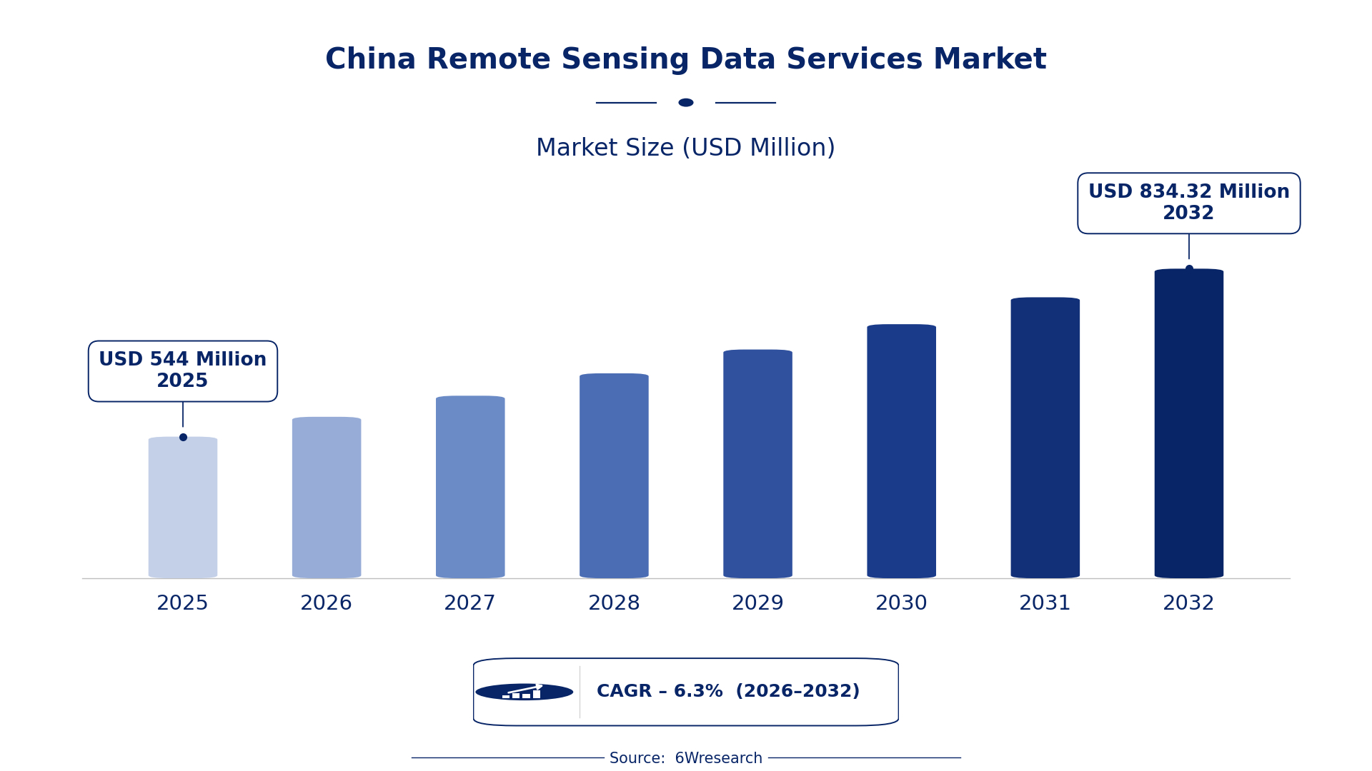
According to 6Wresearch internal database and industry insights, the China Remote Sensing Data Services Market was valued at USD 544.0 million in 2025 and is projected to reach USD 834.32 million by 2032, growing at a CAGR of approximately 6.3% during 2026–2032.
China Remote Sensing Data Services Market Highlights
| Report Metric | Details |
| Report Name | China Remote Sensing Data Services Market |
| Market Size 2025 | USD 544.0 million |
| Market Size 2032 | USD 834.32 million |
| Absolute Growth 2025–2032 | USD 290.32 million |
| CAGR 2026–2032 | 6.3% |
| Peak Annual Growth | 8.7% in 2028 |
| Forecast Period | 2026–2032 |
| Historical Data | 2022–2025 |
| Base Year | 2025 |
| Leading Data Type, 2025 | Satellite Imagery (45% share) |
| Leading Sensor Platform, 2025 | Optical/Radar (39% share) |
| Leading Delivery Method, 2025 | Cloud API (49% share) |
| Leading End User, 2025 | Energy Utilities (48% share) |
| Fastest-Growing Data Type | Drone Mapping (7.3% CAGR) |
| Fastest-Growing Sensor Platform | LiDAR/Multispectral (8.2% CAGR) |
| Fastest-Growing Delivery Method | Real-Time Stream (8.2% CAGR) |
| Fastest-Growing End User | Renewable Energy Operators (8.0% CAGR) |
| Growing Sector | Renewable Energy |
| Key End Users | Energy Utilities, Environmental Regulatory Bodies, Urban Planners |
China Remote Sensing Data Services Market Year-wise Growth Rate and Key Drivers (2022–2032)
This graph illustrates the annual growth rates of the market from 2022 to 2032, highlighting a steady upward trajectory and projected market expansion over the forecast period.
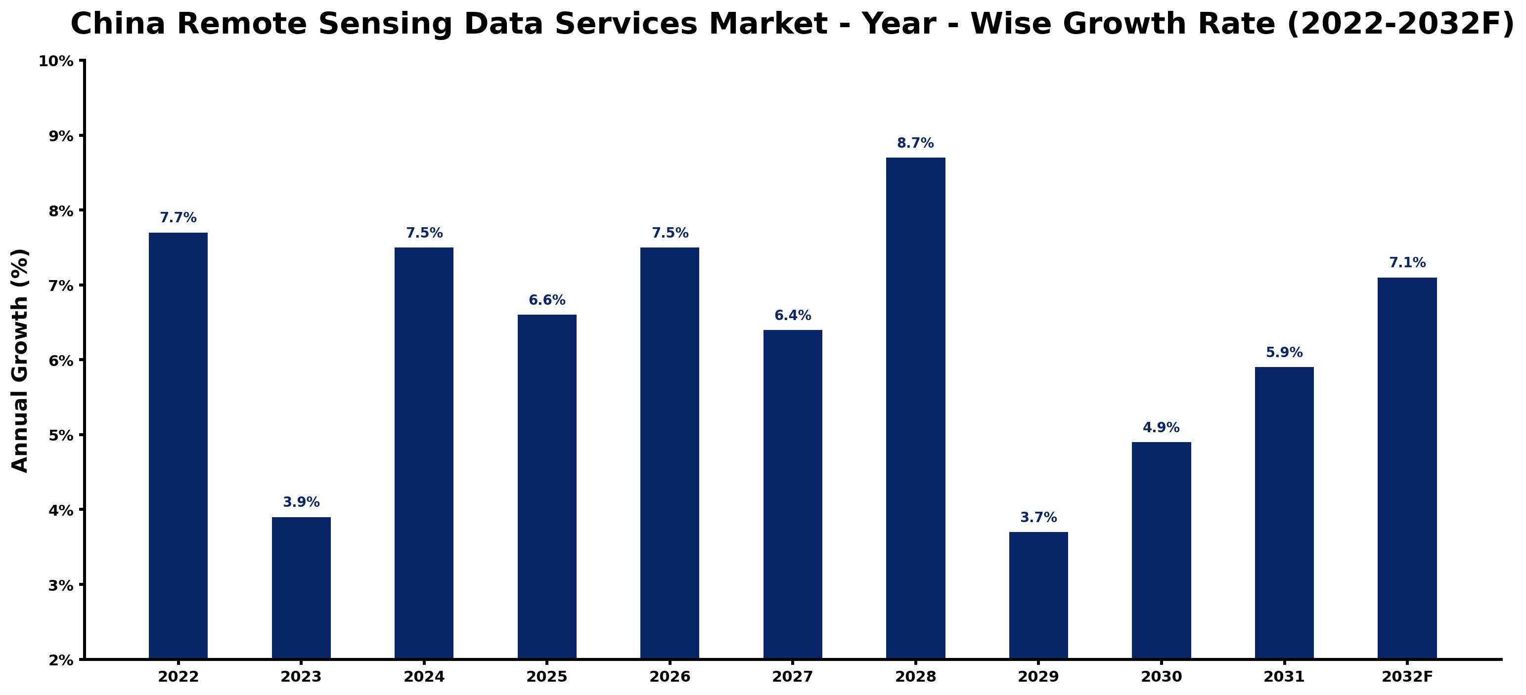
Year by year, the estimates below pair each growth rate with the development that shaped it.
| Year | Estimated Annual Growth (%) | Market Rationale |
| 2022 | 7.7 | The market experienced strong demand from environmental regulatory bodies focused on monitoring. |
| 2023 | 3.9 | Growth slowed as the market adjusted to previous high levels of activity and investment. |
| 2024 | 7.5 | Demand increased due to urban planning initiatives requiring extensive data analysis. |
| 2025 | 6.6 | Growth moderated as the National Remote Sensing Development Plan stabilised the market after rapid expansion in preceding years. |
| 2026 | 7.5 | The market is expected to grow as the integration of remote sensing data into urban planning advances. |
| 2027 | 6.4 | Demand will slow as the market adjusts to the effects of previous growth rates. |
| 2028 | 8.7 | The peak growth year is driven by investments in high-resolution satellite technology and the National Environmental Remote Sensing Monitoring Program. |
| 2029 | 3.7 | Growth will slow as the market stabilises after reaching peak levels in the previous year. |
| 2030 | 4.9 | Demand is projected to rise as urban development projects increase reliance on remote sensing data. |
| 2031 | 5.9 | Growth is expected to rise as the focus on environmental monitoring continues to strengthen. |
| 2032 | 7.1 | The market will grow as renewable energy operators increasingly depend on remote sensing for site assessments. |
Note: Market size estimations and growth projections presented in this report are based on 6Wresearch's proprietary forecasting methodology, utilizing the latest available industry data, government publications, and primary research inputs.
China Remote Sensing Data Services Market Synopsis
China Remote Sensing Data Services Market encompasses the collection and analysis of remote sensing data from satellites and drones, essential for applications such as environmental monitoring and urban planning. The market is expanding due to rising demand from energy utilities and environmental regulatory bodies. Investment in high-resolution satellite technology and the integration of remote sensing into urban planning are key growth drivers. With over 30 operational satellites, the industry is well-equipped to meet the increasing needs of domestic users and governmental bodies.
Market Dynamics Impact Analysis (2026–2032)
| Factor | Type | Impact | Primary Segment Affected |
| Growing demand for environmental monitoring data from regulatory bodies | Driver | High | Environmental Regulatory Bodies |
| Increased reliance on remote sensing for urban planning | Driver | High | Satellite Imagery |
| Investment in high-resolution satellite technology | Opportunity | High | Satellite Imagery |
| Integration of remote sensing data into renewable energy projects | Opportunity | High | Renewable Energy Operators |
| Limited access to high-quality data due to regulatory constraints | Restraint | High | Satellite Imagery |
| High operational costs associated with satellite maintenance | Restraint | Medium | Satellite Imagery |
| Competition from international remote sensing service providers | Challenge | High | Satellite Imagery |
| Technological challenges in data integration and processing | Challenge | Medium | Satellite Imagery |
Evaluation of Drivers in China Remote Sensing Data Services Market (2026–2032)
The factors lifting demand, and the evidence behind each, are summarised below.
| Drivers | Primary Segment Affected | Why It Matters (Evidence) |
| Increased investment in satellite technology | Satellite Imagery | This investment enhances data quality and availability, leading to greater demand for mapping and monitoring services. |
| Growing need for urban planning data | Drone Mapping | Urban planners are increasingly relying on detailed topographical surveys, driving demand for drone mapping services. |
| Focus on environmental monitoring | Optical/Radar | The emphasis on environmental regulations promotes the use of high-resolution imaging for compliance and monitoring. |
| Cloud-based delivery methods | Cloud API | These methods simplify access to remote sensing data, encouraging more users to integrate these services into their operations. |
| Government initiatives supporting data integration | GIS Integrations | These initiatives enhance the use of remote sensing data in various sectors, increasing demand for GIS services. |
The Remote Sensing Data Services market in China is growing on the back of increased investment in satellite technology, demand for urban planning data, and a focus on environmental monitoring. The expansion of the satellite fleet, with over 30 operational satellites, improves data availability for various applications. Cloud-based delivery methods, accounting for 49% of the market, facilitate easier access to critical information.
Evaluation of Restraints in China Remote Sensing Data Services Market
The table below lists the restraints and the evidence behind each.
| Market Restraint | Primary Segment Affected | Why It Matters (Evidence) |
| Regulatory constraints limiting data access | Satellite Imagery | Strict regulations can hinder timely access to essential data for projects. |
| High operational costs for satellite maintenance | Satellite Imagery | Maintaining a fleet of satellites incurs substantial costs, affecting pricing. |
| Limited integration capabilities with existing systems | Satellite Imagery | Challenges in integrating remote sensing data with current infrastructure can delay projects. |
| Competition from international providers | Satellite Imagery | Local firms face pressure from established international remote sensing service providers. |
| Technological challenges in data processing | Satellite Imagery | Complex data processing requirements can lead to delays and increased costs. |
China Remote Sensing Data Services Market Challenges
In the China Remote Sensing Data Services market, fierce competition exists as over 200 companies vie for contracts, which drives down prices and reduces profit margins for buyers. High operational costs burden suppliers, with average annual expenses for satellite data collection reaching 500 million CNY, limiting their capacity to innovate. Many providers struggle with outdated technology, as the rapid evolution of satellite capabilities requires constant updates, leading to service delays for clients. Regulatory requirements from the Ministry of Ecology and Environment complicate compliance, resulting in project delays that impact both buyers and suppliers.
Trends in the China Remote Sensing Data Services Market
Four trends stand out in the China Remote Sensing Data Services Market.
- Shift towards Cloud-Based Data Delivery: The integration of cloud technologies in remote sensing services is transforming data accessibility. The Cloud API segment accounted for 49% of the market in 2025, enabling users to access information more efficiently.
- Increased Focus on Environmental Monitoring: Since the launch of the National Environmental Remote Sensing Monitoring Program in 2021, there has been a push for improved data collection. This initiative allocated 500 million CNY for environmental projects, driving demand.
- Rise of LiDAR Technology in Remote Sensing: LiDAR technology is gaining traction for its ability to provide detailed terrain analysis. With an expected CAGR of 8.2% from 2026 to 2032, it is becoming a preferred choice for various applications.
- Growing Integration of Remote Sensing in Urban Planning: The Ministry of Natural Resources' initiatives are promoting the use of remote sensing data in urban management. This shift is expected to improve planning efficiency and decision-making across cities.
Investment Opportunities in the China Remote Sensing Data Services Market
Several openings in the China Remote Sensing Data Services Market merit attention from investors.
- Partnerships with Local Authorities: Establishing joint ventures with local governments can facilitate access to urban planning projects. The demand for remote sensing data is increasing, with over 300 million CNY allocated for related initiatives.
- Supply of Advanced Remote Sensing Technologies: Investing in high-resolution satellite technology is vital as the market grows. The National Remote Sensing Development Plan aims to improve capabilities by 2025, creating opportunities for suppliers.
- Expansion into Renewable Energy Sector: The renewable energy sector is rapidly growing, with operators increasingly relying on remote sensing data. This presents an opportunity to supply tailored data services to energy utilities, which accounted for 48% of the end-user market.
- Focus on Data Integration Solutions: With the rise of cloud-based services, there is a demand for data integration solutions. The Real-Time Stream segment is projected to grow at 8.2%, indicating a need for innovative services.
Government Initiatives in the China Remote Sensing Data Services Market
In 2021, the Ministry of Ecology and Environment launched the 'National Environmental Remote Sensing Monitoring Program', enhancing data collection for environmental protection. This program builds on previous regulations by providing improved monitoring capabilities and allocating funding for projects. The 'National Remote Sensing Development Plan' approved in 2022 aims to strengthen remote sensing capabilities by 2025, ensuring better data availability for producers and users.
The 'Remote Sensing Data Application Promotion Project' received 300 million CNY in 2023 from the Ministry of Natural Resources, aimed at supporting various sectors. This initiative facilitates access to remote sensing data for urban planning and environmental monitoring, ensuring that producers and users can benefit from improved data availability.
Future Insight of the China Remote Sensing Data Services Market
By 2032, the China Remote Sensing Data Services market is set to undergo substantial transformation, primarily due to advancements in satellite technology and improved data integration methods. The National Remote Sensing Center's initiatives will enhance data quality and accessibility, creating new opportunities for buyers and suppliers. With the government's commitment to environmental monitoring, demand for these services will rise as urban planning incorporates remote sensing. The establishment of the National Standard for Remote Sensing Data Quality will further support service improvements.
Market Segmentation Analysis
The report offers a comprehensive study of the following market segments and their leading categories in the market.
By Data Type – Satellite Imagery Dominated, Drone Mapping Expected to Grow Fastest
According to Ravi Bhandari, Research Head at 6Wresearch, in 2025, Satellite Imagery led the data type split with a 45% share. Satellite Imagery commands a substantial share in the China Remote Sensing Data Services Market due to its essential function in land use mapping and monitoring. With over 30 operational satellites, this technology is integral for applications such as environmental monitoring and urban planning. Over 2026–2032, Drone Mapping is expected to post the fastest growth, at a CAGR of 7.3%. Drone Mapping is experiencing rapid growth, primarily due to its ability to deliver detailed topographical surveys that are increasingly sought after for urban development projects. This trend is particularly pronounced among local governmental bodies that require precise data for planning. Suppliers should focus on enhancing their drone mapping capabilities to meet the growing demand for detailed data services in urban planning.
By Sensor Platform – Optical/Radar Dominated, LiDAR/Multispectral Expected to Grow Fastest
Optical/Radar took a 39% share of sensor platform in 2025, more than any other category. Optical/Radar technology holds a significant market share as it is vital for high-resolution imaging and analysis across various applications. Its effectiveness in capturing detailed data makes it a preferred choice among users in the remote sensing sector. LiDAR/Multispectral is projected to grow fastest, at a CAGR of 8.2% during 2026–2032. LiDAR/Multispectral technology is the fastest-growing segment, driven by its importance in detailed vegetation and terrain analysis. The increasing emphasis on environmental monitoring and sustainable development initiatives is accelerating its adoption. Buyers should invest in LiDAR/Multispectral solutions to leverage their potential for enhanced environmental assessments.
By Delivery Method – Cloud API Dominated, Real-Time Stream Expected to Grow Fastest
The largest delivery method category in 2025 was Cloud API, with a 49% share of total revenue. Cloud API leads the market due to its essential role in integrating and accessing remote sensing data efficiently. This delivery method allows users to obtain and utilise data seamlessly for a variety of applications, making it a preferred choice among service providers. Real-Time Stream is set to record the highest CAGR in this split, 8.2% over 2026–2032. Real-Time Stream is the fastest-growing delivery method, as it enables immediate data access crucial for timely decision-making. The rising demand for rapid responses in environmental monitoring and urban planning is driving this segment's expansion. Suppliers must improve their real-time streaming capabilities to meet the urgent data access needs of their clients.
By End User – Energy Utilities Dominated, Renewable Energy Operators Expected to Grow Fastest
Energy Utilities accounted for a 48% market share by end user in 2025. Energy Utilities represent the largest share of the market, relying heavily on remote sensing data for effective infrastructure management and planning. This sector's need for accurate data to ensure operational efficiency solidifies its leading position. The quickest growth will come from Renewable Energy Operators, forecast to expand at a CAGR of 8.0% between 2026 and 2032. Renewable Energy Operators are the fastest-growing end user segment, as they require precise data for site assessment and monitoring of renewable energy projects. The increasing focus on sustainable energy solutions is significantly propelling this segment's growth. Providers should tailor their services to address the specific data needs of renewable energy operators to capitalise on this growth opportunity.
Key Attractiveness of the Report
- 10 Years of Market Numbers
- Historical Data Starting from 2022 to 2025
- Base Year 2025
- Forecast Data until 2032
- Key Performance Indicators Impacting the Market
- Major Upcoming Developments and Projects
Key Highlights of the Report:
- China Remote Sensing Data Services Market Outlook
- Market Size of China Remote Sensing Data Services Market, 2025
- Forecast of China Remote Sensing Data Services Market, 2032
- Historical Data and Forecast of China Remote Sensing Data Services Revenues & Volume for the Period 2022 - 2032F
- China Remote Sensing Data Services Market Trend Evolution
- China Remote Sensing Data Services Market Drivers and Challenges
- China Remote Sensing Data Services Price Trends
- China Remote Sensing Data Services Porter's Five Forces
- China Remote Sensing Data Services Industry Life Cycle
- Historical Data and Forecast of China Remote Sensing Data Services Market Revenues & Volume By Data Type for the Period 2022 - 2032F
- Historical Data and Forecast of China Remote Sensing Data Services Market Revenues & Volume By Satellite Imagery for the Period 2022 - 2032F
- Historical Data and Forecast of China Remote Sensing Data Services Market Revenues & Volume By Drone Mapping for the Period 2022 - 2032F
- Historical Data and Forecast of China Remote Sensing Data Services Market Revenues & Volume By Ground Sensors for the Period 2022 - 2032F
- Historical Data and Forecast of China Remote Sensing Data Services Market Revenues & Volume By Weather Stations for the Period 2022 - 2032F
- Historical Data and Forecast of China Remote Sensing Data Services Market Revenues & Volume By Sensor Platform for the Period 2022 - 2032F
- Historical Data and Forecast of China Remote Sensing Data Services Market Revenues & Volume By Optical/Radar for the Period 2022 - 2032F
- Historical Data and Forecast of China Remote Sensing Data Services Market Revenues & Volume By LiDAR/Multispectral for the Period 2022 - 2032F
- Historical Data and Forecast of China Remote Sensing Data Services Market Revenues & Volume By Soil/Water/Seismic for the Period 2022 - 2032F
- Historical Data and Forecast of China Remote Sensing Data Services Market Revenues & Volume By IoT Sensor Nodes for the Period 2022 - 2032F
- Historical Data and Forecast of China Remote Sensing Data Services Market Revenues & Volume By Delivery Method for the Period 2022 - 2032F
- Historical Data and Forecast of China Remote Sensing Data Services Market Revenues & Volume By Cloud API for the Period 2022 - 2032F
- Historical Data and Forecast of China Remote Sensing Data Services Market Revenues & Volume By GIS Integrations for the Period 2022 - 2032F
- Historical Data and Forecast of China Remote Sensing Data Services Market Revenues & Volume By Portal Dashboards for the Period 2022 - 2032F
- Historical Data and Forecast of China Remote Sensing Data Services Market Revenues & Volume By Real-Time Stream for the Period 2022 - 2032F
- Historical Data and Forecast of China Remote Sensing Data Services Market Revenues & Volume By End User for the Period 2022 - 2032F
- Historical Data and Forecast of China Remote Sensing Data Services Market Revenues & Volume By Energy Utilities for the Period 2022 - 2032F
- Historical Data and Forecast of China Remote Sensing Data Services Market Revenues & Volume By Pipeline Monitoring Firms for the Period 2022 - 2032F
- Historical Data and Forecast of China Remote Sensing Data Services Market Revenues & Volume By Environmental Regulatory Bodies for the Period 2022 - 2032F
- Historical Data and Forecast of China Remote Sensing Data Services Market Revenues & Volume By Renewable Energy Operators for the Period 2022 - 2032F
- China Remote Sensing Data Services Import Export Trade Statistics
- Market Opportunity Assessment By Data Type
- Market Opportunity Assessment By Sensor Platform
- Market Opportunity Assessment By Delivery Method
- Market Opportunity Assessment By End User
- China Remote Sensing Data Services Top Companies Market Share
- China Remote Sensing Data Services Competitive Benchmarking By Technical and Operational Parameters
- China Remote Sensing Data Services Company Profiles
- China Remote Sensing Data Services Key Strategic Recommendations
Market Covered
Segments analysed in this report are listed below.
By Data Type
- Satellite Imagery
- Drone Mapping
- Ground Sensors
- Weather Stations
By Sensor Platform
- Optical/Radar
- LiDAR/Multispectral
- Soil/Water/Seismic
- IoT Sensor Nodes
By Delivery Method
- Cloud API
- GIS Integrations
- Portal Dashboards
- Real-Time Stream
By End User
- Energy Utilities
- Pipeline Monitoring Firms
- Environmental Regulatory Bodies
- Renewable Energy Operators































