India Satellite Imaging for Farming Market Size & Growth Rate
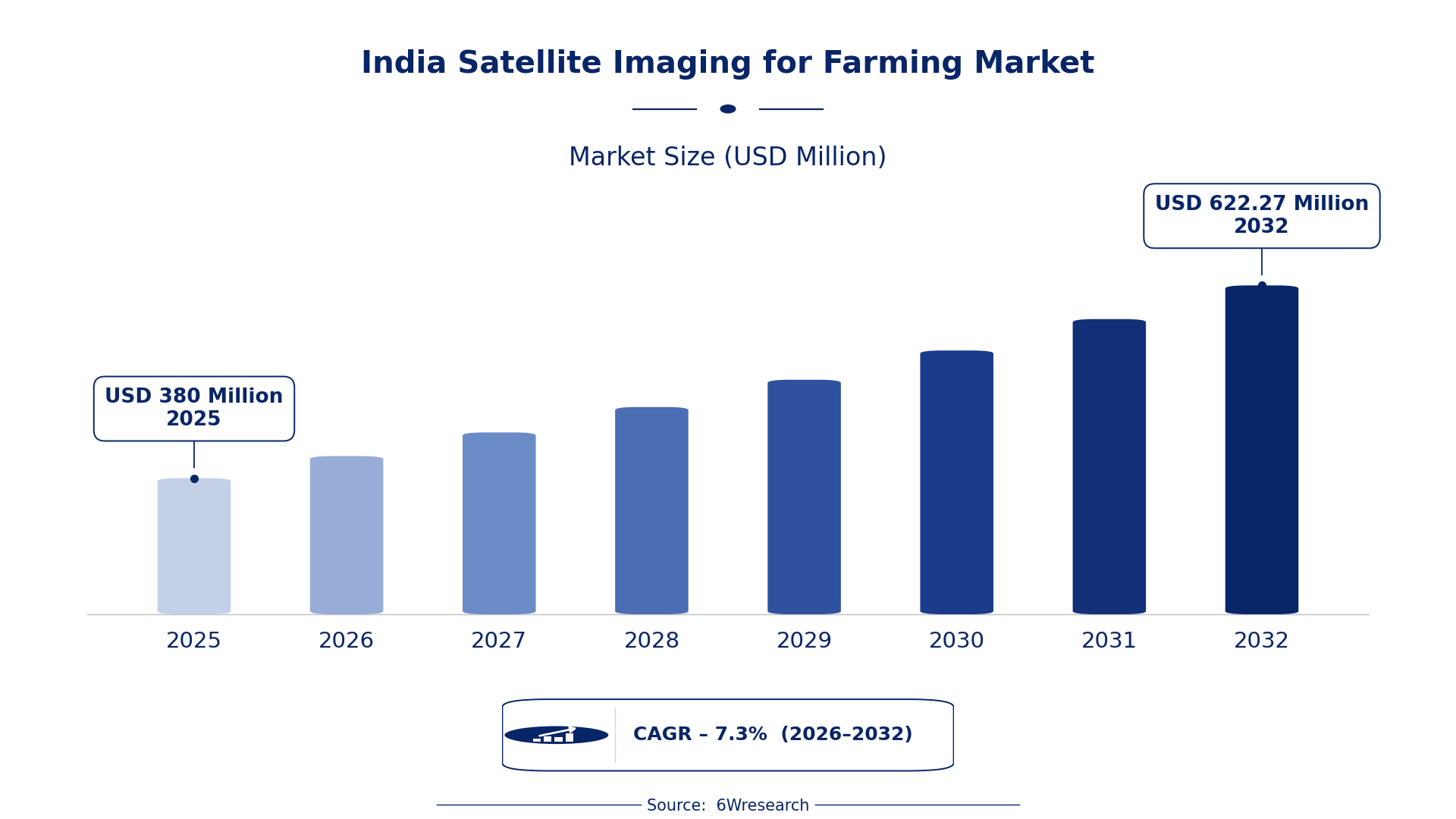
According to 6Wresearch internal database and industry insights, the India Satellite Imaging for Farming Market was valued at USD 380.0 million in 2025 and is projected to reach USD 622.27 million by 2032, growing at a CAGR of approximately 7.3% during 2026–2032.
India Satellite Imaging for Farming Market Highlights
| Report Metric | Details |
| Report Name | India Satellite Imaging for Farming Market |
| Market Size 2025 | USD 380.0 million |
| Market Size 2032 | USD 622.27 million |
| Absolute Growth 2025–2032 | USD 242.27 million |
| CAGR 2026–2032 | 7.3% |
| Peak Annual Growth | 9.6% in 2027 |
| Forecast Period | 2026–2032 |
| Historical Data | 2022–2025 |
| Base Year | 2025 |
| Leading Application Type, 2025 | Crop Monitoring (33% share) |
| Leading Image Type, 2025 | Multispectral (49% share) |
| Leading Delivery Platform, 2025 | Cloud-Based (48% share) |
| Leading End User, 2025 | Agribusiness Companies (44% share) |
| Fastest-Growing Application Type | Soil Moisture Mapping (9.7% CAGR) |
| Fastest-Growing Image Type | Hyperspectral (9.7% CAGR) |
| Fastest-Growing Delivery Platform | Mobile App (8.4% CAGR) |
| Fastest-Growing End User | Agritech Startups (9.3% CAGR) |
| Growing Sector | Agriculture |
| Key End Users | Agribusiness Companies, Precision Farming Firms, Agro Consultants, Agritech Startups |
India Satellite Imaging for Farming Market Year-wise Growth Rate and Key Drivers (2022–2032)
This graph illustrates the annual growth rates of the market from 2022 to 2032, highlighting a steady upward trajectory and projected market expansion over the forecast period.
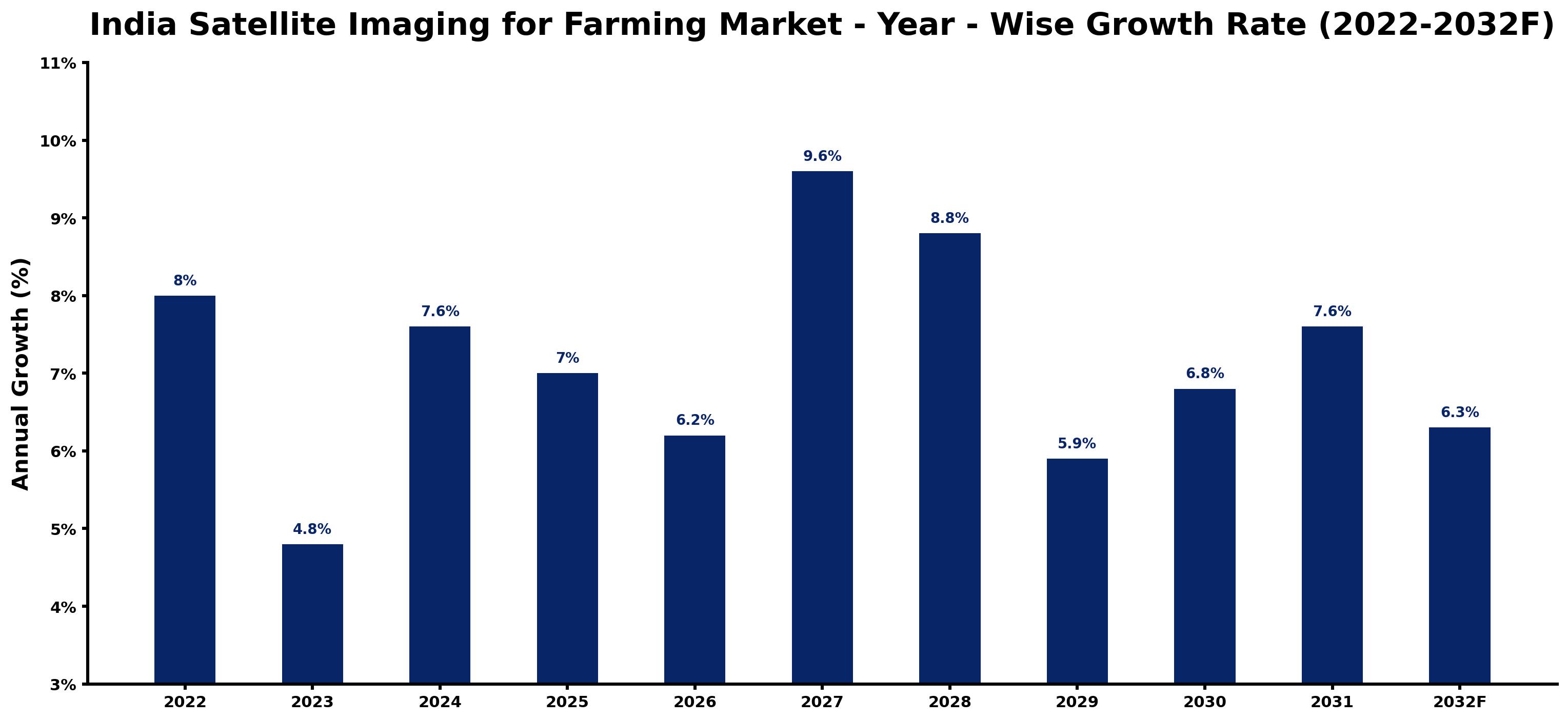
Annual growth estimates for each year appear below with the principal reason behind them, explaining the shifts that set the pace of the market.
| Year | Estimated Annual Growth (%) | Market Rationale |
| 2022 | 8.0 | The market experienced strong growth due to increased technology adoption in farming practices. |
| 2023 | 4.8 | Growth slowed as agribusiness firms adjusted to the previous year's rapid advancements in satellite imaging. |
| 2024 | 7.6 | Demand increased as the Digital Agriculture Mission encouraged wider use of satellite imaging for precision agriculture. |
| 2025 | 7.0 | The market continued to grow, supported by ongoing investments in agricultural technology and infrastructure. |
| 2026 | 6.2 | Growth is expected to slow as the market stabilises following a period of rapid expansion in technology use. |
| 2027 | 9.6 | The market is projected to peak with widespread adoption of satellite imaging technologies among farmers and agribusinesses. |
| 2028 | 8.8 | Growth is anticipated to slow as the market matures and competition intensifies among service providers in the sector. |
| 2029 | 5.9 | Demand is expected to decrease slightly as market saturation begins to take effect in satellite imaging applications. |
| 2030 | 6.8 | Growth will pick up again as new applications of satellite imaging emerge in crop management and monitoring. |
| 2031 | 7.6 | The market is projected to see renewed interest driven by advancements in data analytics and technology integration in agriculture. |
| 2032 | 6.3 | Growth is expected to slow as the market reaches a more stable phase with established practices and user familiarity. |
Note: Market size estimations and growth projections presented in this report are based on 6Wresearch's proprietary forecasting methodology, utilizing the latest available industry data, government publications, and primary research inputs.
India Satellite Imaging for Farming Market Synopsis
Satellite Imaging for Farming in India utilises advanced satellite technology to capture high-resolution images of agricultural lands. This technology aids in monitoring crop health, assessing soil moisture, predicting yields, and detecting pests. The India Satellite Imaging for Farming market is expanding due to rising demand from agribusiness firms and precision farming initiatives. Approximately 58% of the population is employed in agriculture, highlighting the critical need for efficient farming practices. With over 140 million hectares of arable land, the market is set for substantial growth as technology adoption increases.
Market Dynamics Impact Analysis (2026–2032)
| Factor | Type | Impact | Primary Segment Affected |
| Growing adoption of precision farming techniques | Driver | High | Crop Monitoring |
| Increased investment in agricultural technology | Driver | High | Soil Moisture Mapping |
| Expansion of agritech startups utilising satellite data | Opportunity | Medium | Agritech Startups |
| Rising interest in sustainable farming practices | Opportunity | Medium | Precision Farming Firms |
| High initial costs of satellite imaging technology | Restraint | High | Agribusiness Companies |
| Limited awareness among smallholder farmers | Restraint | Medium | Agro Consultants |
| Challenges in data interpretation for end-users | Challenge | High | Agribusiness Companies |
| Dependence on satellite data accuracy and reliability | Challenge | Medium | Precision Farming Firms |
Evaluation of Drivers in India Satellite Imaging for Farming Market (2026–2032)
The main growth drivers and the segments they affect most are set out below.
| Drivers | Primary Segment Affected | Why It Matters (Evidence) |
| Increased crop yield due to technology adoption | Yield Prediction | In 2022, a 5% increase in crop yield was reported due to technology adoption in farming practices. |
| Growing demand for efficient irrigation management | Soil Moisture Mapping | The Pradhan Mantri Krishi Sinchai Yojana aims to improve irrigation efficiency across 10 million hectares by 2025. |
| Rising number of agritech startups | Agritech Startups | The Atmanirbhar Bharat scheme supports local agritech startups in utilising satellite data for innovative solutions. |
| Expansion of precision farming practices | Crop Monitoring | Precision farming technology adoption is targeted to reach 10 million hectares by 2025, boosting demand for satellite imaging. |
| Government initiatives promoting technology in agriculture | Agribusiness Companies | The Digital Agriculture Mission was launched in 2021 with a budget of INR 1,000 crores to enhance technology integration. |
Growth across the Satellite Imaging for Farming market in India is anchored in increased crop yield, efficient irrigation management, and a rise in agritech startups. In 2022, a 5% increase in crop yield was reported due to technology adoption, prompting farmers to invest in satellite imaging. The Pradhan Mantri Krishi Sinchai Yojana aims to improve irrigation efficiency, driving demand for soil moisture mapping. With a target of reaching 10 million hectares by 2025, precision farming is set to boost the market.
Evaluation of Restraints in India Satellite Imaging for Farming Market
The following restraints limit how fast demand can grow.
| Market Restraint | Primary Segment Affected | Why It Matters (Evidence) |
| High initial costs of satellite imaging technology | Agribusiness Companies | The cost of implementing satellite imaging solutions can exceed INR 10 lakhs, limiting adoption by smaller agribusinesses. |
| Limited awareness among smallholder farmers | Agro Consultants | Many smallholder farmers lack knowledge about the benefits of satellite imaging, hindering market growth. |
| Challenges in data interpretation for end-users | Precision Farming Firms | End-users often struggle to interpret satellite data effectively, leading to underutilisation of the technology. |
| Dependence on satellite data accuracy and reliability | Agribusiness Companies | Inaccurate satellite data can lead to poor decision-making, affecting crop management strategies and yields. |
| Regulatory hurdles in technology adoption | Agritech Startups | Complex regulations can slow down the integration of satellite imaging technologies in farming practices. |
India Satellite Imaging for Farming Market Challenges
Buyers in the India Satellite Imaging for Farming market face high initial costs for technology adoption, with systems often exceeding INR 10 lakhs, limiting access for smallholders. Suppliers struggle with inconsistent data quality, as fluctuations in satellite data can lead to inaccurate crop assessments, delaying critical decisions for agribusiness firms. Intense competition among service providers has led to price wars, squeezing profit margins for suppliers and affecting service quality for buyers. Limited satellite data sources can disrupt supply chains, delaying essential imaging for farmers and hindering timely agricultural decisions.
Trends in the India Satellite Imaging for Farming Market
Buyers and suppliers in the India Satellite Imaging for Farming Market are adjusting to the following trends.
- Shift towards Digital Agriculture: The Digital Agriculture Mission launched in 2021 is transforming farming practices by promoting technology adoption. With a budget of INR 1,000 crores, this initiative is increasing the use of satellite imaging in agriculture.
- Expansion of Soil Health Card Scheme: In 2023, the Soil Health Card Scheme was expanded to include satellite-based soil monitoring. This initiative aims to improve nutrient management across India's agricultural lands, benefiting farmers with better insights.
- Increase in Agritech Startups: The rise of agritech startups in India is reshaping agricultural practices. With the Atmanirbhar Bharat scheme supporting local innovations, these startups are utilising satellite data to improve farming efficiency.
- Growing Interest in Precision Farming: The adoption of precision farming techniques is increasing, driven by the need for sustainable practices. The target of 10 million hectares by 2025 highlights the urgency for efficient agricultural methods.
Investment Opportunities in the India Satellite Imaging for Farming Market
Several openings in the India Satellite Imaging for Farming Market merit attention from investors.
- Investment in Agritech Startups: With government support, agritech startups are experiencing growth, particularly in satellite data applications. The Atmanirbhar Bharat scheme encourages innovation, with a budget allocation aimed at enhancing local capabilities.
- Supply of Satellite Imaging Solutions: The demand for satellite imaging solutions is rising as farmers seek precision agriculture tools. Agribusiness companies are increasingly looking for reliable service providers to improve crop management.
- Expansion of Precision Farming Services: The growing interest in precision farming presents opportunities for service providers to offer tailored solutions. Agritech startups can capitalise on this trend by developing innovative products.
- Development of Mobile Applications: The rise of mobile technology offers a chance to create applications that provide farmers with real-time satellite data. The mobile app segment is expected to grow significantly, driven by user demand.
Government Initiatives in the India Satellite Imaging for Farming Market
The Digital Agriculture Mission, launched in 2021, aims to enhance technology adoption in farming with a budget of INR 1,000 crores. This initiative complements the National Policy on Agriculture, updated in 2020, which promotes the use of satellite imaging for precision farming. Together, these measures aim to improve agricultural productivity and efficiency across India, benefiting producers and buyers alike.
Agribusiness companies are utilising the Digital Agriculture Mission to access funding for technology integration. The Soil Health Card Scheme, expanded in 2023 to include satellite-based soil monitoring, provides farmers with essential data for nutrient management. Additionally, the Indian Space Research Organisation (ISRO) supports agricultural monitoring by providing satellite data, enhancing the capabilities of farmers and agribusinesses.
Future Insight of the India Satellite Imaging for Farming Market
The India Satellite Imaging for Farming market is set to evolve significantly by 2032, driven by advancements in satellite technology and supportive government initiatives. The Pradhan Mantri Krishi Sinchai Yojana will enhance irrigation efficiency, while the National Agricultural Innovation Project will promote technology integration in agriculture. By 2025, precision farming is expected to cover 10 million hectares, allowing agribusiness firms to utilise data more effectively. Increased funding of INR 2,000 crores for agricultural technology development will further stimulate innovation and improve productivity in the sector.
Market Segmentation Analysis
The analysis below covers each segmentation, its leading category in 2025 and its fastest-growing category through 2032.
By Application Type – Crop Monitoring Dominated, Soil Moisture Mapping Expected to Grow Fastest
According to Shubham Padhi, Research Analyst at 6Wresearch, the largest application type category in 2025 was Crop Monitoring, with a 33% share of total revenue. Crop monitoring holds the largest share in India as it is essential for assessing crop health and growth stages. The reliance on accurate crop monitoring is evident, especially with over 140 million hectares of arable land needing effective farming practices. Soil Moisture Mapping is projected to grow fastest, at a CAGR of 9.7% during 2026–2032. Soil moisture mapping is experiencing rapid growth due to the increasing need for efficient irrigation management. Initiatives like the Pradhan Mantri Krishi Sinchai Yojana promote advanced irrigation techniques, driving demand for this technology. Suppliers should focus on enhancing soil moisture mapping solutions to meet the growing needs of farmers.
By Image Type – Multispectral Dominated, Hyperspectral Expected to Grow Fastest
Multispectral held a 49% share of the India Satellite Imaging for Farming Market by image type in 2025. Multispectral imaging dominates the market as it captures data across various wavelengths, making it invaluable for comprehensive agricultural analysis. This capability is crucial for agribusiness companies that require detailed insights for effective decision-making. Over 2026–2032, Hyperspectral is expected to post the fastest growth, at a CAGR of 9.7%. Hyperspectral imaging is the fastest-growing segment, primarily driven by its application in research, which is gaining traction in the agricultural sector. As agritech startups explore its potential, this segment is expected to expand rapidly. Buyers should consider investing in hyperspectral imaging solutions to stay ahead in agricultural research and development.
By Delivery Platform – Cloud-Based Dominated, Mobile App Expected to Grow Fastest
Cloud-Based took a 48% share of delivery platform in 2025, more than any other category. Cloud-based platforms lead the market due to their ability to provide scalable data storage and processing, which is vital for agribusiness companies managing vast amounts of satellite data. This technology supports the growing trend of data-driven farming practices. Mobile App is set to record the highest CAGR in this split, 8.4% over 2026–2032. Mobile apps are the fastest-growing delivery platform as they enable farmers to access critical data on-the-go, enhancing their ability to make timely decisions. The convenience of mobile access aligns with the increasing adoption of precision farming technologies. Suppliers must prioritise mobile app development to cater to the evolving needs of tech-savvy farmers.
By End User – Agribusiness Companies Dominated, Agritech Startups Expected to Grow Fastest
Agribusiness Companies accounted for a 44% market share by end user in 2025. Agribusiness companies represent the largest share of the market as they leverage satellite data for strategic decision-making in agricultural practices. Their significant investment in technology directly impacts productivity across the sector. The quickest growth will come from Agritech Startups, forecast to expand at a CAGR of 9.3% between 2026 and 2032. Agritech startups are the fastest-growing end-user segment, driven by their focus on developing innovative solutions that utilise satellite imaging. This trend is supported by government initiatives encouraging technology adoption in agriculture. Suppliers should target agritech startups to capitalise on the innovation and growth potential within the agricultural technology sector.
Key Attractiveness of the Report
- 10 Years of Market Numbers
- Historical Data Starting from 2022 to 2025
- Base Year 2025
- Forecast Data until 2032
- Key Performance Indicators Impacting the Market
- Major Upcoming Developments and Projects
Key Highlights of the Report:
- India Satellite Imaging for Farming Market Outlook
- Market Size of India Satellite Imaging for Farming Market, 2025
- Forecast of India Satellite Imaging for Farming Market, 2032
- Historical Data and Forecast of India Satellite Imaging for Farming Revenues & Volume for the Period 2022 - 2032F
- India Satellite Imaging for Farming Market Trend Evolution
- India Satellite Imaging for Farming Market Drivers and Challenges
- India Satellite Imaging for Farming Price Trends
- India Satellite Imaging for Farming Porter's Five Forces
- India Satellite Imaging for Farming Industry Life Cycle
- Historical Data and Forecast of India Satellite Imaging for Farming Market Revenues & Volume By Application Type for the Period 2022 - 2032F
- Historical Data and Forecast of India Satellite Imaging for Farming Market Revenues & Volume By Crop Monitoring for the Period 2022 - 2032F
- Historical Data and Forecast of India Satellite Imaging for Farming Market Revenues & Volume By Soil Moisture Mapping for the Period 2022 - 2032F
- Historical Data and Forecast of India Satellite Imaging for Farming Market Revenues & Volume By Yield Prediction for the Period 2022 - 2032F
- Historical Data and Forecast of India Satellite Imaging for Farming Market Revenues & Volume By Pest Detection for the Period 2022 - 2032F
- Historical Data and Forecast of India Satellite Imaging for Farming Market Revenues & Volume By Image Type for the Period 2022 - 2032F
- Historical Data and Forecast of India Satellite Imaging for Farming Market Revenues & Volume By Multispectral for the Period 2022 - 2032F
- Historical Data and Forecast of India Satellite Imaging for Farming Market Revenues & Volume By Thermal for the Period 2022 - 2032F
- Historical Data and Forecast of India Satellite Imaging for Farming Market Revenues & Volume By Hyperspectral for the Period 2022 - 2032F
- Historical Data and Forecast of India Satellite Imaging for Farming Market Revenues & Volume By SAR for the Period 2022 - 2032F
- Historical Data and Forecast of India Satellite Imaging for Farming Market Revenues & Volume By Delivery Platform for the Period 2022 - 2032F
- Historical Data and Forecast of India Satellite Imaging for Farming Market Revenues & Volume By Mobile App for the Period 2022 - 2032F
- Historical Data and Forecast of India Satellite Imaging for Farming Market Revenues & Volume By Web Dashboard for the Period 2022 - 2032F
- Historical Data and Forecast of India Satellite Imaging for Farming Market Revenues & Volume By Cloud-Based for the Period 2022 - 2032F
- Historical Data and Forecast of India Satellite Imaging for Farming Market Revenues & Volume By API Integration for the Period 2022 - 2032F
- Historical Data and Forecast of India Satellite Imaging for Farming Market Revenues & Volume By End User for the Period 2022 - 2032F
- Historical Data and Forecast of India Satellite Imaging for Farming Market Revenues & Volume By Agribusiness Companies for the Period 2022 - 2032F
- Historical Data and Forecast of India Satellite Imaging for Farming Market Revenues & Volume By Precision Farming Firms for the Period 2022 - 2032F
- Historical Data and Forecast of India Satellite Imaging for Farming Market Revenues & Volume By Agro Consultants for the Period 2022 - 2032F
- Historical Data and Forecast of India Satellite Imaging for Farming Market Revenues & Volume By Agritech Startups for the Period 2022 - 2032F
- India Satellite Imaging for Farming Import Export Trade Statistics
- Market Opportunity Assessment By Application Type
- Market Opportunity Assessment By Image Type
- Market Opportunity Assessment By Delivery Platform
- Market Opportunity Assessment By End User
- India Satellite Imaging for Farming Top Companies Market Share
- India Satellite Imaging for Farming Competitive Benchmarking By Technical and Operational Parameters
- India Satellite Imaging for Farming Company Profiles
- India Satellite Imaging for Farming Key Strategic Recommendations
Market Covered
The report offers an extensive study of the following market segments.
By Application Type
- Crop Monitoring
- Soil Moisture Mapping
- Yield Prediction
- Pest Detection
By Image Type
- Multispectral
- Thermal
- Hyperspectral
- SAR
By Delivery Platform
- Mobile App
- Web Dashboard
- Cloud-Based
- API Integration
By End User
- Agribusiness Companies
- Precision Farming Firms
- Agro Consultants
- Agritech Startups































