China Satellite Imaging for Farming Market Size & Growth Rate
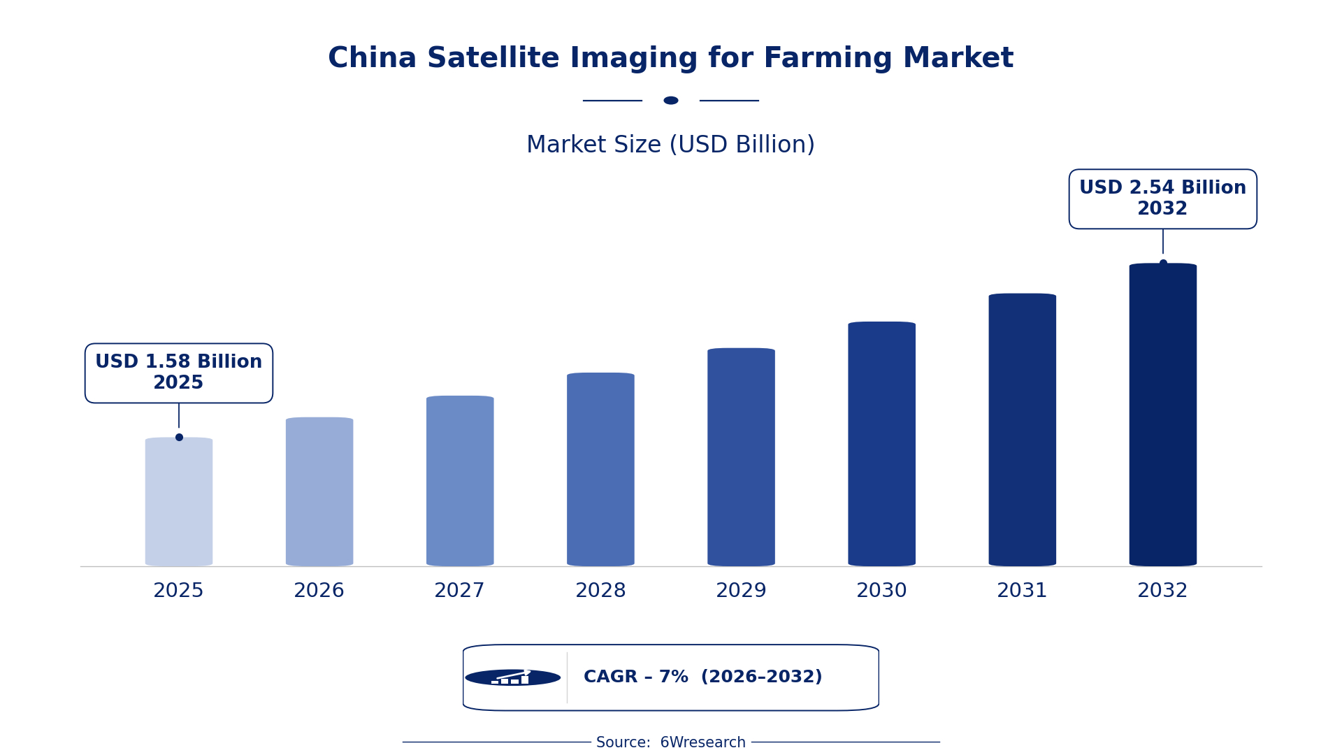
According to 6Wresearch internal database and industry insights, the China Satellite Imaging for Farming Market was valued at USD 1.58 billion in 2025 and is projected to reach USD 2.54 billion by 2032, growing at a CAGR of approximately 7% during 2026–2032.
China Satellite Imaging for Farming Market Highlights
| Report Metric | Details |
| Report Name | China Satellite Imaging for Farming Market |
| Market Size 2025 | USD 1.58 billion |
| Market Size 2032 | USD 2.54 billion |
| Absolute Growth 2025–2032 | USD 0.96 billion |
| CAGR 2026–2032 | 7% |
| Peak Annual Growth | 8.5% in 2028 |
| Forecast Period | 2026–2032 |
| Historical Data | 2022–2025 |
| Base Year | 2025 |
| Leading Application Type, 2025 | Crop Monitoring (41% share) |
| Leading Image Type, 2025 | Multispectral (50% share) |
| Leading Delivery Platform, 2025 | Web Dashboard (44% share) |
| Leading End User, 2025 | Agribusiness Companies (35% share) |
| Fastest-Growing Application Type | Soil Moisture Mapping (9.1% CAGR) |
| Fastest-Growing Delivery Platform | Cloud-Based (8.0% CAGR) |
| Fastest-Growing End User | Precision Farming Firms (8.8% CAGR) |
| Growing Sector | Agribusiness |
| Key End Users | Agribusiness Companies, Precision Farming Firms, Agro Consultants, Agritech Startups |
China Satellite Imaging for Farming Market Year-wise Growth Rate and Key Drivers (2022–2032)
This graph illustrates the annual growth rates of the market from 2022 to 2032, highlighting a steady upward trajectory and projected market expansion over the forecast period.
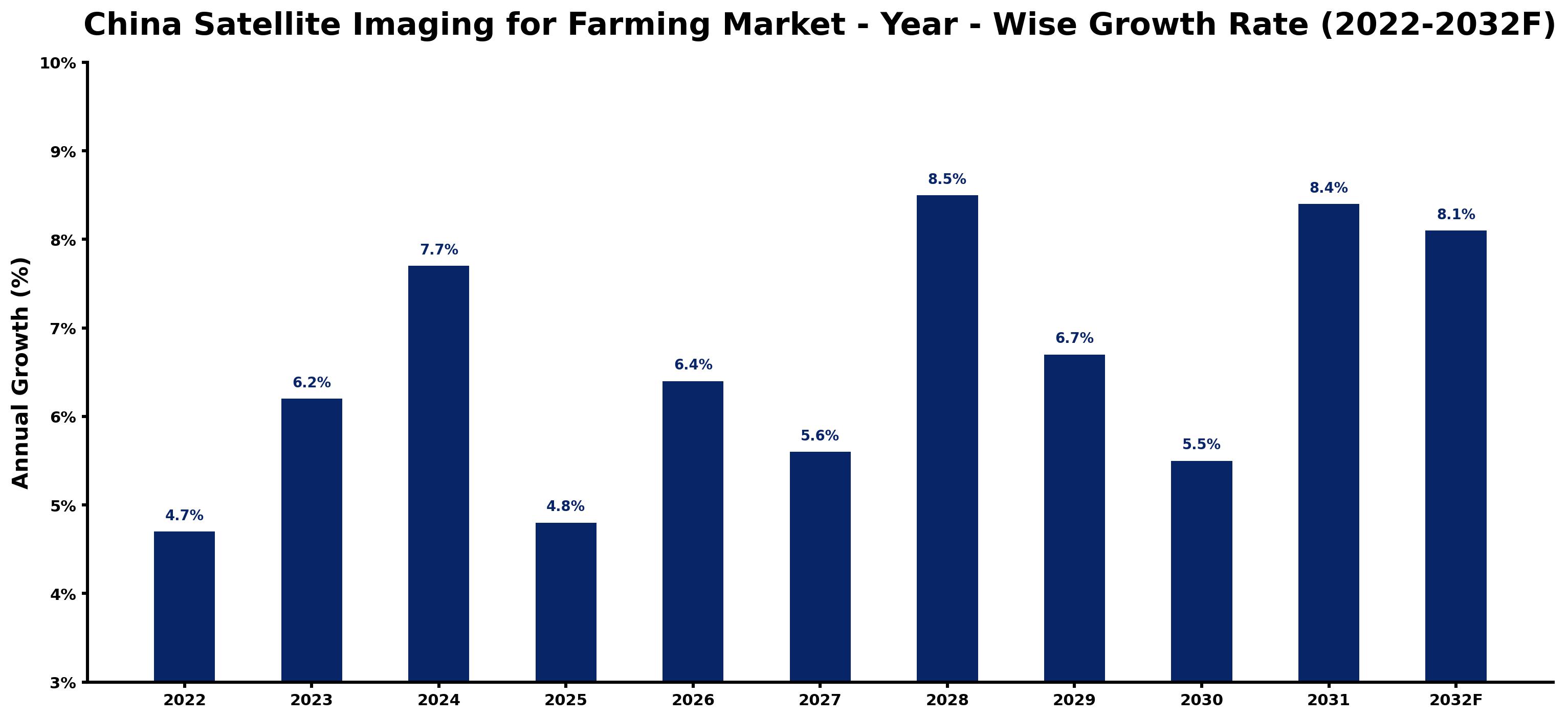
Below, each year's estimated growth is shown next to the factor that most influenced it.
| Year | Estimated Annual Growth (%) | Market Rationale |
| 2022 | 4.7 | The market experienced steady growth as agribusiness companies began adopting satellite imaging technologies. |
| 2023 | 6.2 | Demand increased due to the Agricultural Technology Promotion Law, which encouraged precision farming initiatives and improved technology access. |
| 2024 | 7.7 | Growth accelerated as more farmers recognised the benefits of crop monitoring and yield prediction through the National Standard for Remote Sensing Applications in Agriculture. |
| 2025 | 4.8 | A slowdown occurred as some farms faced challenges in integrating new technologies into existing practices, particularly among smaller operations. |
| 2026 | 6.4 | Adoption of soil moisture mapping is likely to rise as large agricultural operations become more aware of its benefits. |
| 2027 | 5.6 | Expansion is expected to continue, albeit at a slower pace, as precision farming firms increase their reliance on satellite data for operational efficiency. |
| 2028 | 8.5 | A peak in growth is anticipated as the government intensifies efforts to modernise agriculture through satellite imaging initiatives. |
| 2029 | 6.7 | Growth is likely to moderate as market participants adjust to the rapid technological advancements in satellite imaging solutions. |
| 2030 | 5.5 | The market will maintain growth, but at a reduced rate, as farmers seek cost-effective solutions for precision agriculture. |
| 2031 | 8.4 | Growth is projected to rebound as agribusiness companies invest more in satellite imaging for operational efficiency and productivity. |
| 2032 | 8.1 | A slight slowdown in growth is anticipated as the market stabilises after a period of rapid expansion. |
Note: Market size estimations and growth projections presented in this report are based on 6Wresearch's proprietary forecasting methodology, utilizing the latest available industry data, government publications, and primary research inputs.
China Satellite Imaging for Farming Market Synopsis
Satellite Imaging for Farming in China utilises satellite technology to monitor agricultural fields, delivering essential data for crop management and yield prediction. This technology captures images via advanced sensors, allowing farmers to refine their practices. The China Satellite Imaging for Farming Market is expanding due to robust demand from agribusiness companies and precision farming firms. In 2022, the government allocated $200 million for agricultural modernisation initiatives, further propelling investment in satellite imaging applications. The Yangtze River Delta is a pivotal region for these advancements, highlighting the role of technology in contemporary agriculture.
Market Dynamics Impact Analysis (2026–2032)
| Factor | Type | Impact | Primary Segment Affected |
| Government support for precision agriculture initiatives | Driver | High | Crop Monitoring |
| Increasing adoption of satellite imaging for soil moisture mapping | Driver | High | Soil Moisture Mapping |
| Rising demand for efficient food production due to population growth | Opportunity | High | Yield Prediction |
| Emerging agritech startups leveraging satellite data for innovative solutions | Opportunity | Medium | Pest Detection |
| Challenges in technology integration among smaller farms | Restraint | High | Soil Moisture Mapping |
| Limited awareness of satellite imaging benefits among traditional farmers | Restraint | Medium | Crop Monitoring |
| The high initial investment costs for satellite imaging technology | Challenge | High | Yield Prediction |
| Dependence on government policies for funding and support | Challenge | Medium | Pest Detection |
Evaluation of Drivers in China Satellite Imaging for Farming Market (2026–2032)
The factors lifting demand, and the evidence behind each, are summarised below.
| Drivers | Primary Segment Affected | Why It Matters (Evidence) |
| Government initiatives promoting precision agriculture | Crop Monitoring | The Ministry of Agriculture promotes precision farming through satellite technology, leading to increased adoption among farmers, with funding of $200 million in 2022. |
| Growing awareness of soil moisture management benefits | Soil Moisture Mapping | In 2022, 40% of precision farming firms reported using satellite imaging for soil moisture mapping, driving demand for these services and improving irrigation practices. |
| Rising population necessitating efficient food production | Yield Prediction | China's population of approximately 1.4 billion creates a pressing need for enhanced agricultural productivity and yield forecasting, driving demand for satellite imaging solutions. |
| Technological advancements in satellite imaging capabilities | Pest Detection | The National Remote Sensing Center of China oversees satellite data applications, improving pest detection methods for farmers and enhancing crop protection strategies. |
| Increased investment in agritech startups | Pest Detection | Emerging agritech startups are creating innovative solutions using satellite data, enhancing pest management for farmers and driving market growth. |
Approximately 40% of precision farming firms reported using satellite imaging for soil moisture mapping, which is essential for effective irrigation management. The growing population of about 1.4 billion necessitates improved agricultural productivity and yield forecasting. Advancements in satellite imaging capabilities are improving pest detection methods, supporting market growth and enabling farmers to better protect their crops.
Evaluation of Restraints in China Satellite Imaging for Farming Market
Below mentioned are some major restraints and their influence on market dynamics.
| Market Restraint | Primary Segment Affected | Why It Matters (Evidence) |
| High initial investment costs for satellite imaging technology | Yield Prediction | Many farmers find the initial costs prohibitive, limiting widespread adoption of satellite imaging solutions, with expenses averaging $500,000 for advanced sensors. |
| Limited awareness of satellite imaging benefits among traditional farmers | Crop Monitoring | Traditional farmers often lack knowledge about the advantages of satellite imaging, hindering market growth and adoption rates. |
| Challenges in technology integration among smaller farms | Soil Moisture Mapping | Smaller farms face difficulties in integrating satellite imaging technology into their existing practices, which can delay efficiency improvements. |
| Dependence on government policies for funding and support | Pest Detection | The market's growth is heavily reliant on government initiatives, which can be inconsistent and affect farmers' ability to adopt new technologies. |
| Slow adoption rates due to complexity of technology | Soil Moisture Mapping | The complexity of satellite imaging technology can deter farmers from adopting these solutions, leading to lower usage rates. |
China Satellite Imaging for Farming Market Challenges
In the China Satellite Imaging for Farming Market, regulatory compliance imposes delays for precision farming firms, as adhering to the National Standard for Remote Sensing Agricultural Monitoring can take up to six months. The high costs of advanced imaging sensors, which can reach $500,000, deter technology adoption, particularly for smaller farms that struggle to implement these solutions. Competition among agribusiness companies escalates as over 50% already use satellite technology, leading to price wars that erode profit margins for new entrants. Additionally, the average monthly fee for satellite data access is around $1,000, which restricts smaller producers' ability to effectively monitor crop health.
Trends in the China Satellite Imaging for Farming Market
Several trends are reshaping the China Satellite Imaging for Farming Market; the most important are set out below.
- Shift towards Precision Agriculture: Agribusiness companies are increasingly adopting precision agriculture techniques, utilising satellite imaging for crop monitoring. In 2022, over 50% of agribusiness companies in China employed satellite imaging, indicating a strong trend towards data-driven farming.
- Increased Use of Multispectral Imaging: The Yangtze River Delta is seeing a rise in the use of multispectral imaging for assessing crop health. This trend is supported by a 9.4% CAGR in multispectral imaging adoption, reflecting its cost-effectiveness for farmers.
- Growth in Cloud-Based Delivery Platforms: The adoption of cloud-based platforms for satellite data delivery is gaining traction among precision farming firms. With a projected CAGR of 8.0%, this trend improves data accessibility and analysis capabilities for farmers.
- Emergence of Agritech Startups: Agritech startups are creating innovative solutions for farmers using satellite data. In recent years, the number of startups in this sector has surged, reflecting a growing interest in technology-driven agriculture.
Investment Opportunities in the China Satellite Imaging for Farming Market
Some of the investment opportunities in the China Satellite Imaging for Farming Market are mentioned below.
- Investment in Satellite Imaging Solutions: With over 300 million hectares of arable land in China, there is a strong opportunity to supply satellite imaging solutions. Agribusiness companies are actively seeking advanced technologies to boost operational efficiency and productivity.
- Expanding Precision Agriculture Market: The precision agriculture market is projected to grow, aiming for 50% adoption by 2025. This presents an opportunity for technology providers to collaborate with farms for implementation and support.
- Development of Mobile Applications for Farmers: The increasing smartphone penetration among farmers creates an opportunity to develop mobile applications for satellite data access. Partnering with local agribusiness firms can facilitate market entry and enhance user experience.
- Enhancing Soil Moisture Mapping Technologies: As soil moisture mapping adoption increases, there is an opportunity to supply advanced imaging technologies. Precision farming firms are seeking innovative solutions to optimise irrigation management and improve crop yields.
Government Initiatives in the China Satellite Imaging for Farming Market
The Agricultural Technology Promotion Law, revised in 2022, identifies satellite imaging as a key technology for improving agricultural efficiency. This law mandates that producers integrate advanced technologies into their practices, ensuring better crop management. Additionally, the National Standard for Remote Sensing Applications in Agriculture, established in 2021, standardises the use of satellite data, promoting consistency and reliability in agricultural monitoring. The Smart Agriculture Development Plan launched in 2023 aims to integrate satellite imaging into 30% of farms by 2025, further enhancing agricultural productivity and providing farmers with vital data to make informed decisions.
Various initiatives support satellite imaging integration in farming, overseen by the Ministry of Agriculture. The National Remote Sensing Agricultural Monitoring Program, updated in 2021, enhances data accessibility for farmers, allowing them to make informed decisions. The China National Space Administration funds agricultural satellite missions, ensuring that farmers have access to the latest technology. The Agro-Tech Innovation Program promotes advanced technologies in agriculture, providing grants and support for projects that incorporate satellite imaging, thereby improving efficiency and productivity for producers.
Future Insight of the China Satellite Imaging for Farming Market
Several forward-looking factors should support the China Satellite Imaging for Farming Market over the coming years. The government's Agricultural Technology Promotion Plan aims to enhance technology use, likely increasing satellite adoption among farmers. The target to elevate precision agriculture adoption to 50% by 2025 will expand the market for satellite services. The growing use of thermal imaging for irrigation management will drive further advancements, enabling buyers and suppliers to optimise crop management and improve overall productivity.
Market Segmentation Analysis
The report offers a comprehensive study of the following market segments and their leading categories in the market.
By Application Type – Crop Monitoring Dominated, Soil Moisture Mapping Expected to Grow Fastest
According to Shubham Padhi, Research Analyst at 6Wresearch, Crop Monitoring held a 41% share of the China Satellite Imaging for Farming Market by application type in 2025. Crop monitoring commands the largest share as it is vital for providing real-time data on crop health and growth stages. This capability is particularly essential for agribusiness companies managing extensive arable land, which exceeds 300 million hectares in China. Over 2026–2032, Soil Moisture Mapping is expected to post the fastest growth, at a CAGR of 9.1%. Soil moisture mapping is rapidly growing due to its importance for effective irrigation management and optimising water usage. In 2022, 40% of precision farming firms reported using this technology, indicating a robust upward trend. Suppliers should focus on developing soil moisture mapping solutions to meet the increasing demand from precision farming firms.
By Image Type – Multispectral Dominated and Is Expected to Record the Fastest Growth
The largest image type category in 2025 was Multispectral, with a 50% share of total revenue. Multispectral imaging leads the market because it is widely used for assessing crop health through various light wavelengths. Its ability to deliver detailed insights makes it the preferred choice among agribusiness companies throughout China. Its lead should widen, with a projected CAGR of 9.4% during 2026–2032, the highest in this split. The multispectral segment is also the fastest-growing, as its applications in precision agriculture are expanding significantly. This dual role ensures that its market share will continue to widen considerably. Suppliers must invest in advanced multispectral imaging technologies to maintain a competitive advantage in this expanding market.
By Delivery Platform – Web Dashboard Dominated, Cloud-Based Expected to Grow Fastest
Web Dashboard took a 44% share of delivery platform in 2025, more than any other category. The web dashboard holds the largest market share as it provides comprehensive data analysis and visualisation for users, which is crucial for agribusiness companies. Its user-friendly interface facilitates effective monitoring of extensive agricultural areas. Cloud-Based is set to record the highest CAGR in this split, 8.0% over 2026–2032. Cloud-based platforms are experiencing rapid growth due to their ability to offer easy data storage and accessibility for users. As more agribusinesses adopt digital solutions, this segment is poised for increased uptake. Suppliers should enhance cloud-based offerings to align with the rising preference for accessible data management solutions.
By End User – Agribusiness Companies Dominated, Precision Farming Firms Expected to Grow Fastest
In 2025, Agribusiness Companies led the end user split with a 35% share. Agribusiness companies represent the largest share as they are major users of satellite imaging for operational efficiency in managing vast agricultural lands. Their reliance on precise data drives the demand for advanced imaging solutions. The quickest growth will come from Precision Farming Firms, forecast to expand at a CAGR of 8.8% between 2026 and 2032. Precision farming firms are the fastest-growing segment, heavily relying on satellite data for precision agriculture practices. As the government aims to increase precision agriculture adoption to 50% by 2025, this segment's growth is expected to accelerate. Suppliers should tailor their offerings to meet the specific needs of precision farming firms to capitalise on this growth opportunity.
Key Attractiveness of the Report
- 10 Years of Market Numbers
- Historical Data Starting from 2022 to 2025
- Base Year 2025
- Forecast Data until 2032
- Key Performance Indicators Impacting the Market
- Major Upcoming Developments and Projects
Key Highlights of the Report:
- China Satellite Imaging for Farming Market Outlook
- Market Size of China Satellite Imaging for Farming Market, 2025
- Forecast of China Satellite Imaging for Farming Market, 2032
- Historical Data and Forecast of China Satellite Imaging for Farming Revenues & Volume for the Period 2022 - 2032F
- China Satellite Imaging for Farming Market Trend Evolution
- China Satellite Imaging for Farming Market Drivers and Challenges
- China Satellite Imaging for Farming Price Trends
- China Satellite Imaging for Farming Porter's Five Forces
- China Satellite Imaging for Farming Industry Life Cycle
- Historical Data and Forecast of China Satellite Imaging for Farming Market Revenues & Volume By Application Type for the Period 2022 - 2032F
- Historical Data and Forecast of China Satellite Imaging for Farming Market Revenues & Volume By Crop Monitoring for the Period 2022 - 2032F
- Historical Data and Forecast of China Satellite Imaging for Farming Market Revenues & Volume By Soil Moisture Mapping for the Period 2022 - 2032F
- Historical Data and Forecast of China Satellite Imaging for Farming Market Revenues & Volume By Yield Prediction for the Period 2022 - 2032F
- Historical Data and Forecast of China Satellite Imaging for Farming Market Revenues & Volume By Pest Detection for the Period 2022 - 2032F
- Historical Data and Forecast of China Satellite Imaging for Farming Market Revenues & Volume By Image Type for the Period 2022 - 2032F
- Historical Data and Forecast of China Satellite Imaging for Farming Market Revenues & Volume By Multispectral for the Period 2022 - 2032F
- Historical Data and Forecast of China Satellite Imaging for Farming Market Revenues & Volume By Thermal for the Period 2022 - 2032F
- Historical Data and Forecast of China Satellite Imaging for Farming Market Revenues & Volume By Hyperspectral for the Period 2022 - 2032F
- Historical Data and Forecast of China Satellite Imaging for Farming Market Revenues & Volume By SAR for the Period 2022 - 2032F
- Historical Data and Forecast of China Satellite Imaging for Farming Market Revenues & Volume By Delivery Platform for the Period 2022 - 2032F
- Historical Data and Forecast of China Satellite Imaging for Farming Market Revenues & Volume By Mobile App for the Period 2022 - 2032F
- Historical Data and Forecast of China Satellite Imaging for Farming Market Revenues & Volume By Web Dashboard for the Period 2022 - 2032F
- Historical Data and Forecast of China Satellite Imaging for Farming Market Revenues & Volume By Cloud-Based for the Period 2022 - 2032F
- Historical Data and Forecast of China Satellite Imaging for Farming Market Revenues & Volume By API Integration for the Period 2022 - 2032F
- Historical Data and Forecast of China Satellite Imaging for Farming Market Revenues & Volume By End User for the Period 2022 - 2032F
- Historical Data and Forecast of China Satellite Imaging for Farming Market Revenues & Volume By Agribusiness Companies for the Period 2022 - 2032F
- Historical Data and Forecast of China Satellite Imaging for Farming Market Revenues & Volume By Precision Farming Firms for the Period 2022 - 2032F
- Historical Data and Forecast of China Satellite Imaging for Farming Market Revenues & Volume By Agro Consultants for the Period 2022 - 2032F
- Historical Data and Forecast of China Satellite Imaging for Farming Market Revenues & Volume By Agritech Startups for the Period 2022 - 2032F
- China Satellite Imaging for Farming Import Export Trade Statistics
- Market Opportunity Assessment By Application Type
- Market Opportunity Assessment By Image Type
- Market Opportunity Assessment By Delivery Platform
- Market Opportunity Assessment By End User
- China Satellite Imaging for Farming Top Companies Market Share
- China Satellite Imaging for Farming Competitive Benchmarking By Technical and Operational Parameters
- China Satellite Imaging for Farming Company Profiles
- China Satellite Imaging for Farming Key Strategic Recommendations
Market Covered
This report examines the market across the segments below.
By Application Type
- Crop Monitoring
- Soil Moisture Mapping
- Yield Prediction
- Pest Detection
By Image Type
- Multispectral
- Thermal
- Hyperspectral
- SAR
By Delivery Platform
- Mobile App
- Web Dashboard
- Cloud-Based
- API Integration
By End User
- Agribusiness Companies
- Precision Farming Firms
- Agro Consultants
- Agritech Startups































