India Satellite Imaging Market Size & Growth Rate
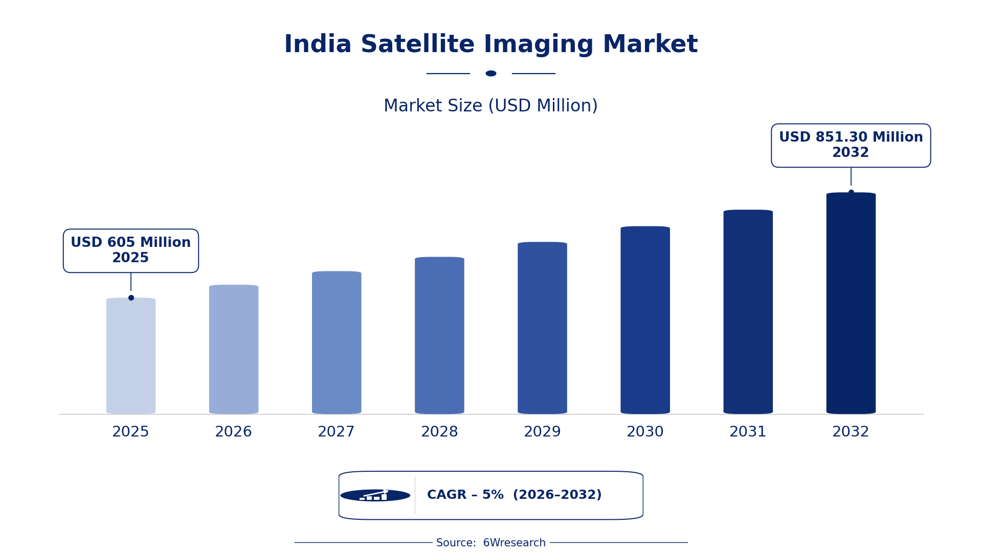
According to 6Wresearch internal database and industry insights, the India Satellite Imaging Market was valued at USD 605.0 million in 2025 and is projected to reach USD 851.30 million by 2032, growing at a CAGR of approximately 5% during 2026–2032.
India Satellite Imaging Market Highlights
| Report Metric | Details |
| Report Name | India Satellite Imaging Market |
| Market Size 2025 | USD 605.0 million |
| Market Size 2032 | USD 851.30 million |
| Absolute Growth 2025–2032 | USD 246.30 million |
| CAGR 2026–2032 | 5% |
| Peak Annual Growth | 7.6% in 2032 |
| Forecast Period | 2026–2032 |
| Historical Data | 2022–2025 |
| Base Year | 2025 |
| Leading Imaging Type, 2025 | Optical Imaging (49% share) |
| Leading Frequency Spectrum, 2025 | Visible & Near IR (43% share) |
| Leading Application Type, 2025 | Urban Planning (36% share) |
| Leading End User, 2025 | Government Bodies (49% share) |
| Fastest-Growing Imaging Type | Radar Imaging (6.6% CAGR) |
| Fastest-Growing Frequency Spectrum | Microwave (6.8% CAGR) |
| Fastest-Growing Application Type | Environmental Monitoring (7.2% CAGR) |
| Fastest-Growing End User | Research Institutes (6.0% CAGR) |
| Growing Sector | Environmental Monitoring |
| Key End Users | Urban Planning, Defense Surveillance, Environmental Monitoring, Scientific Analysis |
India Satellite Imaging Market Year-wise Growth Rate and Key Drivers (2022–2032)
This graph illustrates the annual growth rates of the market from 2022 to 2032, highlighting a steady upward trajectory and projected market expansion over the forecast period.
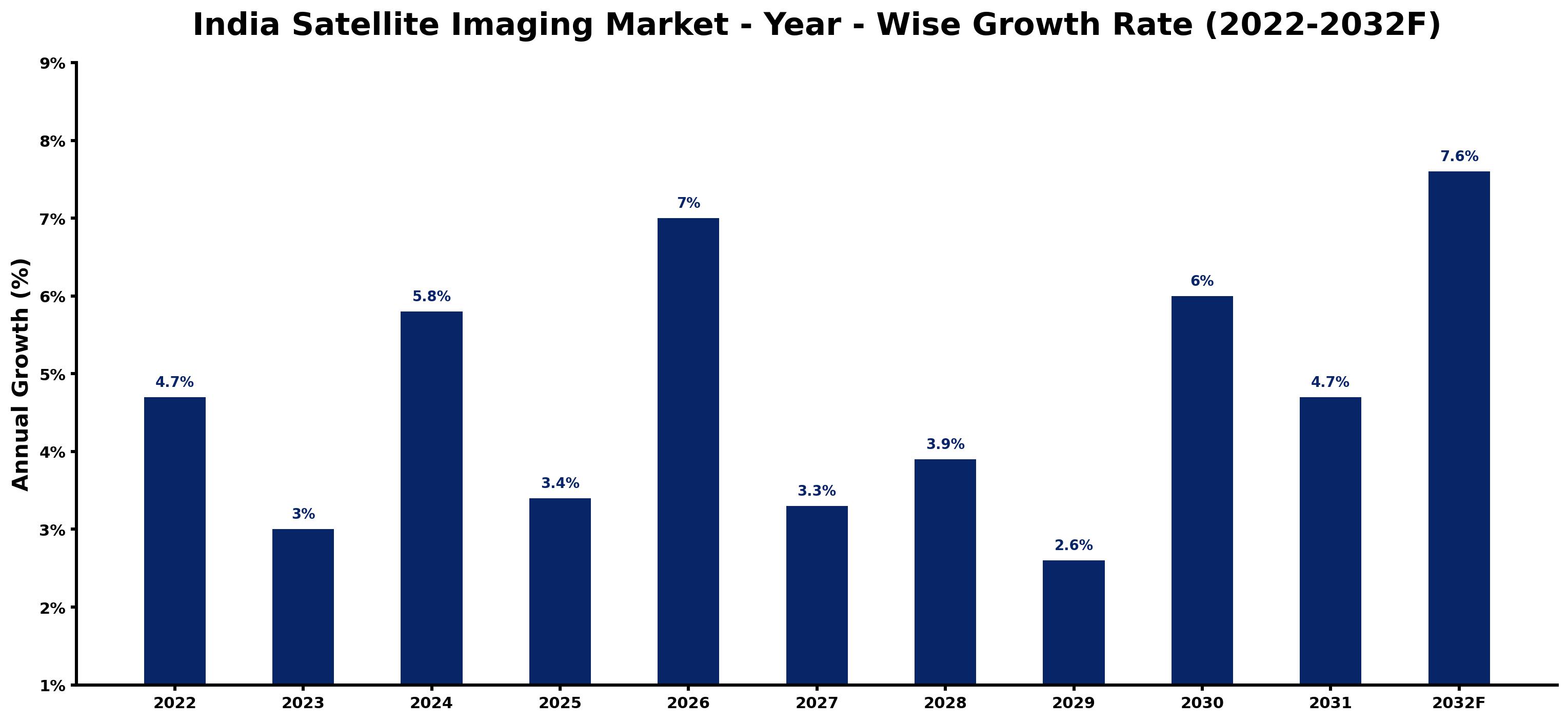
The following table presents the estimated annual growth rate for each year together with the principal factor influencing market performance.
| Year | Estimated Annual Growth (%) | Market Rationale |
| 2022 | 4.7 | The market experienced steady growth, supported by increased satellite launches and urban planning initiatives. |
| 2023 | 3.0 | Growth slowed due to a temporary reduction in satellite imaging projects amid budget constraints. |
| 2024 | 5.8 | Demand surged as urban planning initiatives across 28 states gained momentum. |
| 2025 | 3.4 | Growth slowed again as the market adjusted to prior rapid expansions and project timelines. |
| 2026 | 7.0 | A resurgence in satellite launches is expected to drive growth as government bodies increase their imaging needs. |
| 2027 | 3.3 | The market will see a slowdown as project completions lead to fewer new initiatives. |
| 2028 | 3.9 | Growth is projected to pick up again as environmental monitoring projects are prioritised by various agencies. |
| 2029 | 2.6 | A slowdown is anticipated as the market stabilises after a series of high-profile satellite launches. |
| 2030 | 6.0 | Demand will increase as urban planning projects expand across the country. |
| 2031 | 4.7 | Growth is expected to slow again as the market adjusts to previous years' rapid expansions. |
| 2032 | 7.6 | The market is projected to peak with strong demand from government bodies and urban planning initiatives. |
Note: Market size estimations and growth projections presented in this report are based on 6Wresearch's proprietary forecasting methodology, utilizing the latest available industry data, government publications, and primary research inputs.
India Satellite Imaging Market Synopsis
The India Satellite Imaging Market encompasses technology that captures images of the Earth's surface using satellites equipped with various sensors. This technology integrates satellite systems, imaging sensors, and data processing for applications such as urban planning, environmental monitoring, and defense surveillance. The market is expected to grow due to government initiatives and a population exceeding 1.4 billion, which creates a strong demand for land use monitoring. In 2023, the Indian government allocated ₹1,500 crores for satellite technology development, further enhancing capabilities. Key buyers include government bodies and defense departments, driving the demand for advanced imaging solutions.
Market Dynamics Impact Analysis (2026–2032)
| Factor | Type | Impact | Primary Segment Affected |
| Increased satellite launches drive demand for imaging services. | Driver | High | Urban Planning |
| Government initiatives promote environmental monitoring, boosting demand. | Driver | High | Environmental Monitoring |
| Growing urbanisation creates a need for detailed land use analysis. | Opportunity | High | Urban Planning |
| Investment in satellite technology is increasing, opening new markets. | Opportunity | Medium | Research Institutes |
| Budget constraints limit the number of satellite launches. | Restraint | High | Defense Surveillance |
| Regulatory hurdles can delay satellite project approvals. | Restraint | Medium | Environmental Monitoring |
| The market still has to solve a few problems, including regulatory delays. | Challenge | High | Urban Planning |
| Competition for funding among various satellite projects can limit resources. | Challenge | Medium | Defense Surveillance |
Evaluation of Drivers in India Satellite Imaging Market (2026–2032)
Key forces behind demand, with the segment each one moves most, are listed below.
| Drivers | Primary Segment Affected | Why It Matters (Evidence) |
| Increased funding for satellite technology development. | Urban Planning | The Indian government allocated ₹1,500 crores for satellite technology development in 2023, boosting urban planning capabilities. |
| Growing need for environmental monitoring services. | Environmental Monitoring | The Ministry of Environment, Forest and Climate Change has supported initiatives since 2021, increasing the need for satellite imaging. |
| Rising urbanisation necessitates detailed land use analysis. | Urban Planning | India's population exceeds 1.4 billion, creating substantial demand for land use monitoring services. |
| Expansion of satellite launches boosts imaging services. | Defense Surveillance | In 2022, India launched 54 satellites for various applications, including imaging, enhancing surveillance capabilities. |
| Technological advancements improve imaging quality and accessibility. | Research Institutes | The National Remote Sensing Centre in Hyderabad enhances data processing capabilities, increasing demand from research institutes. |
Expansion of the Satellite Imaging market in India is supported by increased investment in satellite technology, rising urbanisation, and a growing need for environmental monitoring services. Demand for satellite imaging is rising across various sectors, including defense and urban development, driven by a population exceeding 1.4 billion. The National Remote Sensing Centre in Hyderabad is improving data processing capabilities, which is expected to increase demand from research institutions. The ongoing integration of satellite imaging in smart city projects will further elevate demand across multiple applications.
Evaluation of Restraints in India Satellite Imaging Market
The main factors holding the market back are set out below.
| Market Restraint | Primary Segment Affected | Why It Matters (Evidence) |
| Technological limitations can restrict imaging capabilities. | Research Institutes | Some research institutes lack access to advanced satellite imaging technology, affecting research outcomes. |
| High operational costs can limit project feasibility. | Environmental Monitoring | Budget constraints faced by government bodies can delay the implementation of satellite imaging projects. |
| Limited access to satellite data for smaller firms. | Urban Planning | Smaller firms may struggle to obtain necessary satellite data, hindering their ability to compete in urban planning initiatives. |
| Dependence on specific satellite components can disrupt supply chains. | Defense Surveillance | A leading supplier on particular satellite components can lead to delays in project timelines for defense applications. |
| Regulatory hurdles can slow down project approvals. | Research Institutes | Complex approval processes can delay the initiation of satellite imaging projects for research purposes. |
India Satellite Imaging Market Challenges
Producers in the India satellite imaging market face supply chain disruptions due to reliance on specific components, leading to project delays of up to six months for government contracts. Skills shortages in advanced imaging technology hinder producers, resulting in a 20% reduction in productivity that limits their ability to fulfil contracts. Cost pressures arise from the ₹1,500 crores allocated for satellite technology development, forcing smaller firms to increase prices by 15% to remain competitive. Technology gaps in data processing capabilities restrict the effectiveness of satellite imagery, impacting local governments' urban planning efforts.
Trends in the India Satellite Imaging Market
Four trends stand out in the India Satellite Imaging Market.
- Shift from Traditional to Advanced Imaging Techniques: Since 2021, the adoption of advanced imaging techniques has increased. The National Remote Sensing Centre is now using improved sensors that enhance data quality, resulting in a 20% increase in project efficiency.
- Transition from Government to Private Sector Participation: In 2023, the National Space Policy encouraged private sector involvement in satellite launches. This shift is projected to increase the number of satellite launches by 30% by 2025, creating new market opportunities.
- Emergence of Environmental Monitoring as a Priority: From 2021, environmental monitoring has gained prominence in satellite imaging applications. The Ministry of Environment, Forest and Climate Change initiated several projects, increasing demand for imaging services by 15%.
- Growing Integration of Satellite Imaging in Urban Planning: In 2020, the Digital India Programme included satellite imaging for urban planning. This integration has led to a 25% increase in the use of satellite data for city development across India.
Investment Opportunities in the India Satellite Imaging Market
The following opportunities in the India Satellite Imaging Market pair current demand with a clear way in.
- Collaborate with Local Agencies for Satellite Launches: With the Indian government aiming to increase satellite launches by 30% by 2025, partnerships with local agencies can facilitate entry into the market. This presents an opportunity for technology providers to expand their reach.
- Invest in Research Institutes for Advanced Imaging Solutions: Research institutes are increasingly seeking advanced imaging solutions, driven by a growing need for data. Collaborating with these institutes can open new revenue streams, especially in urban planning.
- Target Environmental Monitoring Projects: As demand for environmental monitoring rises, suppliers can focus on government bodies that require satellite imaging services. This is an opportune time to invest in technology that meets these needs.
- Engage in Joint Ventures for Urban Planning Initiatives: The ongoing urbanisation in India creates a demand for satellite imaging in city planning. Engaging in joint ventures with local authorities can facilitate access to projects and resources.
Government Initiatives in the India Satellite Imaging Market
The National Space Policy 2023, established by the Department of Space, aims to improve satellite imaging capabilities and promote private sector participation in satellite launches. This policy encourages investment in satellite technology, which is important for urban planning and environmental monitoring. By fostering collaboration between public and private sectors, the policy is projected to increase the efficiency and frequency of satellite launches, benefiting various applications. The Indian government has set a target to increase satellite launches by 30% by 2025, which will enhance the overall capabilities of the sector.
The National Remote Sensing Programme, launched by the Ministry of Earth Sciences in 2021, focuses on improving data availability for environmental monitoring. This programme funds projects that utilise satellite imaging for tracking environmental changes. Government bodies, such as the Indian Meteorological Department, benefit from this initiative, using satellite data for weather forecasting and disaster management, which boosts their operational capabilities. The programme has allocated significant resources to ensure timely access to satellite data for various applications.
Future Insight of the India Satellite Imaging Market
By 2032, buyers and suppliers in the India satellite imaging market can expect notable advancements, supported by the updated National Policy on Space Activities, which aims for a 25% increase in satellite launches by 2025. The National Remote Sensing Centre will improve data processing efficiency, facilitating better applications for land use monitoring. Government initiatives will ensure timely access to satellite data for urban planning across 28 states. With India's population exceeding 1.4 billion, the demand for satellite imaging will rise, driving further technological innovations.
Market Segmentation Analysis
Each segment group is reviewed below, with the leader by share and the fastest grower by CAGR.
By Imaging Type – Optical Imaging Dominated, Radar Imaging Expected to Grow Fastest
According to Shubham Padhi, Research Analyst at 6Wresearch, Optical Imaging took a 49% share of imaging type in 2025, more than any other category. Optical Imaging holds the largest market share because it is fundamental for urban planning and detailed surface analysis. The Indian government's extensive urban planning initiatives across 28 states heavily rely on this technology for successful execution. Over 2026–2032, Radar Imaging is expected to post the fastest growth, at a CAGR of 6.6%. Radar Imaging is witnessing rapid growth due to its effectiveness in all weather conditions, making it ideal for surveillance. The increasing focus on security measures and monitoring capabilities is significantly boosting demand for this imaging type. Suppliers should focus on enhancing Radar Imaging solutions to address the growing needs in security and surveillance sectors.
By Frequency Spectrum – Visible & Near IR Dominated, Microwave Expected to Grow Fastest
In 2025, Visible & Near IR led the frequency spectrum split with a 43% share. Visible & Near IR captures the largest market share as it is crucial for agriculture and land use mapping, serving a wide array of applications. The vibrant agricultural sector in India drives substantial demand for this frequency spectrum. The quickest growth will come from Microwave, forecast to expand at a CAGR of 6.8% between 2026 and 2032. Microwave technology is growing swiftly due to its critical role in weather forecasting and climate studies. The Indian Meteorological Department's dependence on this technology for precise predictions is accelerating its adoption. Buyers in meteorology should invest in Microwave technology to improve forecasting accuracy and climate analysis.
By Application Type – Urban Planning Dominated, Environmental Monitoring Expected to Grow Fastest
Urban Planning held a 36% share of the India Satellite Imaging Market by application type in 2025. Urban Planning commands the largest market share as it is essential for city development and infrastructure planning. The ongoing urbanisation in India necessitates effective satellite imaging for informed decision-making in urban initiatives. Environmental Monitoring is projected to grow fastest, at a CAGR of 7.2% during 2026–2032. Environmental Monitoring is rapidly expanding as it plays a vital role in tracking environmental changes and natural disasters. Government initiatives aimed at enhancing environmental oversight are significantly driving demand for this application type. Suppliers must align their offerings with the increasing needs of Environmental Monitoring to meet the demands of government and research institutions.
By End User – Government Bodies Dominated, Research Institutes Expected to Grow Fastest
With a 49% revenue share in 2025, Government Bodies was the largest end user category. Government Bodies represent the largest market share as they are the primary users for policy-making and planning. The substantial budget allocation of ₹1,500 crores for satellite technology development in 2023 underscores their pivotal role in this sector. Research Institutes are set to record the highest CAGR in this split, 6.0% over 2026–2032. Research Institutes are experiencing the fastest growth as they are significant users for academic and scientific research. The rising emphasis on scientific analysis and environmental studies is leading to increased demand from these institutions. Suppliers should tailor their products to meet the specific needs of Research Institutes to capitalise on this expanding segment.
Key Attractiveness of the Report
- 10 Years of Market Numbers
- Historical Data Starting from 2022 to 2025
- Base Year 2025
- Forecast Data until 2032
- Key Performance Indicators Impacting the Market
- Major Upcoming Developments and Projects
Key Highlights of the Report:
- India Satellite Imaging Market Outlook
- Market Size of India Satellite Imaging Market, 2025
- Forecast of India Satellite Imaging Market, 2032
- Historical Data and Forecast of India Satellite Imaging Revenues & Volume for the Period 2022 - 2032F
- India Satellite Imaging Market Trend Evolution
- India Satellite Imaging Market Drivers and Challenges
- India Satellite Imaging Price Trends
- India Satellite Imaging Porter's Five Forces
- India Satellite Imaging Industry Life Cycle
- Historical Data and Forecast of India Satellite Imaging Market Revenues & Volume By Imaging Type for the Period 2022 - 2032F
- Historical Data and Forecast of India Satellite Imaging Market Revenues & Volume By Optical Imaging for the Period 2022 - 2032F
- Historical Data and Forecast of India Satellite Imaging Market Revenues & Volume By Radar Imaging for the Period 2022 - 2032F
- Historical Data and Forecast of India Satellite Imaging Market Revenues & Volume By Infrared Imaging for the Period 2022 - 2032F
- Historical Data and Forecast of India Satellite Imaging Market Revenues & Volume By UV Imaging for the Period 2022 - 2032F
- Historical Data and Forecast of India Satellite Imaging Market Revenues & Volume By Frequency Spectrum for the Period 2022 - 2032F
- Historical Data and Forecast of India Satellite Imaging Market Revenues & Volume By Visible & Near IR for the Period 2022 - 2032F
- Historical Data and Forecast of India Satellite Imaging Market Revenues & Volume By Microwave for the Period 2022 - 2032F
- Historical Data and Forecast of India Satellite Imaging Market Revenues & Volume By Mid-IR for the Period 2022 - 2032F
- Historical Data and Forecast of India Satellite Imaging Market Revenues & Volume By Ultraviolet for the Period 2022 - 2032F
- Historical Data and Forecast of India Satellite Imaging Market Revenues & Volume By Application Type for the Period 2022 - 2032F
- Historical Data and Forecast of India Satellite Imaging Market Revenues & Volume By Urban Planning for the Period 2022 - 2032F
- Historical Data and Forecast of India Satellite Imaging Market Revenues & Volume By Defense Surveillance for the Period 2022 - 2032F
- Historical Data and Forecast of India Satellite Imaging Market Revenues & Volume By Environmental Monitoring for the Period 2022 - 2032F
- Historical Data and Forecast of India Satellite Imaging Market Revenues & Volume By Scientific Analysis for the Period 2022 - 2032F
- Historical Data and Forecast of India Satellite Imaging Market Revenues & Volume By End User for the Period 2022 - 2032F
- Historical Data and Forecast of India Satellite Imaging Market Revenues & Volume By Government Bodies for the Period 2022 - 2032F
- Historical Data and Forecast of India Satellite Imaging Market Revenues & Volume By Defense Departments for the Period 2022 - 2032F
- Historical Data and Forecast of India Satellite Imaging Market Revenues & Volume By Meteorological Agencies for the Period 2022 - 2032F
- Historical Data and Forecast of India Satellite Imaging Market Revenues & Volume By Research Institutes for the Period 2022 - 2032F
- India Satellite Imaging Import Export Trade Statistics
- Market Opportunity Assessment By Imaging Type
- Market Opportunity Assessment By Frequency Spectrum
- Market Opportunity Assessment By Application Type
- Market Opportunity Assessment By End User
- India Satellite Imaging Top Companies Market Share
- India Satellite Imaging Competitive Benchmarking By Technical and Operational Parameters
- India Satellite Imaging Company Profiles
- India Satellite Imaging Key Strategic Recommendations
Market Covered
Segments analysed in this report are listed below.
By Imaging Type
- Optical Imaging
- Radar Imaging
- Infrared Imaging
- UV Imaging
By Frequency Spectrum
- Visible & Near IR
- Microwave
- Mid-IR
- Ultraviolet
By Application Type
- Urban Planning
- Defense Surveillance
- Environmental Monitoring
- Scientific Analysis
By End User
- Government Bodies
- Defense Departments
- Meteorological Agencies
- Research Institutes































