China Satellite Imaging Market Size & Growth Rate
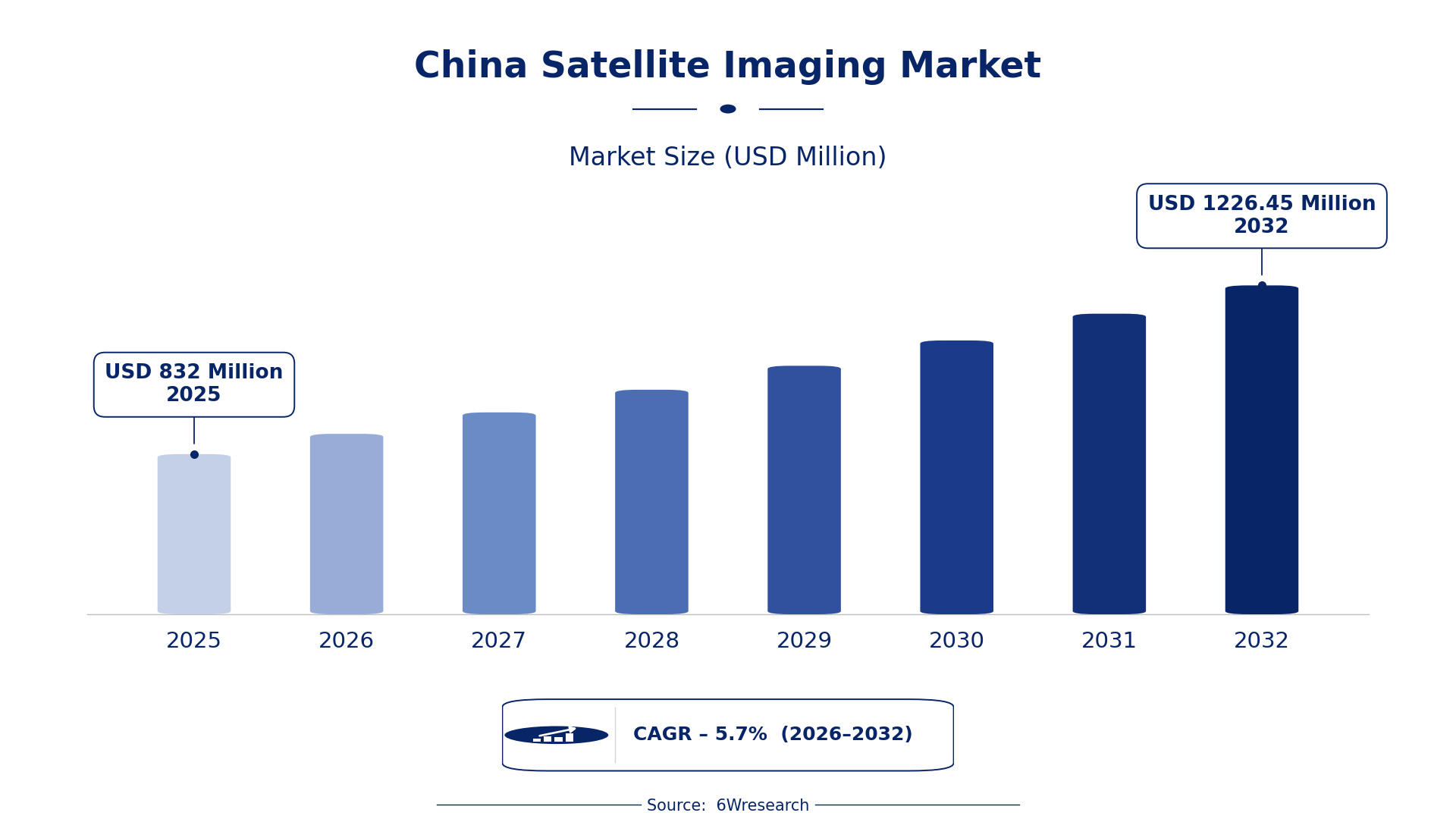
According to 6Wresearch internal database and industry insights, the China Satellite Imaging Market was valued at USD 832.0 million in 2025 and is projected to reach USD 1,226.45 million by 2032, growing at a CAGR of approximately 5.7% during 2026–2032.
China Satellite Imaging Market Highlights
| Report Metric | Details |
| Report Name | China Satellite Imaging Market |
| Market Size 2025 | USD 832.0 million |
| Market Size 2032 | USD 1,226.45 million |
| Absolute Growth 2025–2032 | USD 394.45 million |
| CAGR 2026–2032 | 5.7% |
| Peak Annual Growth | 8.0% in 2030 |
| Forecast Period | 2026–2032 |
| Historical Data | 2022–2025 |
| Base Year | 2025 |
| Leading Imaging Type, 2025 | Optical Imaging (52% share) |
| Leading Frequency Spectrum, 2025 | Visible & Near IR (39% share) |
| Leading Application Type, 2025 | Urban Planning (37% share) |
| Leading End User, 2025 | Government Bodies (49% share) |
| Fastest-Growing Imaging Type | Infrared Imaging (7.8% CAGR) |
| Fastest-Growing Frequency Spectrum | Microwave (7.1% CAGR) |
| Fastest-Growing Application Type | Environmental Monitoring (8.1% CAGR) |
| Fastest-Growing End User | Research Institutes (6.9% CAGR) |
| Growing Sector | Urban Planning |
| Key End Users | Government Bodies, Defense Departments, Research Institutes, Meteorological Agencies |
China Satellite Imaging Market Year-wise Growth Rate and Key Drivers (2022–2032)
This graph illustrates the annual growth rates of the market from 2022 to 2032, highlighting a steady upward trajectory and projected market expansion over the forecast period.
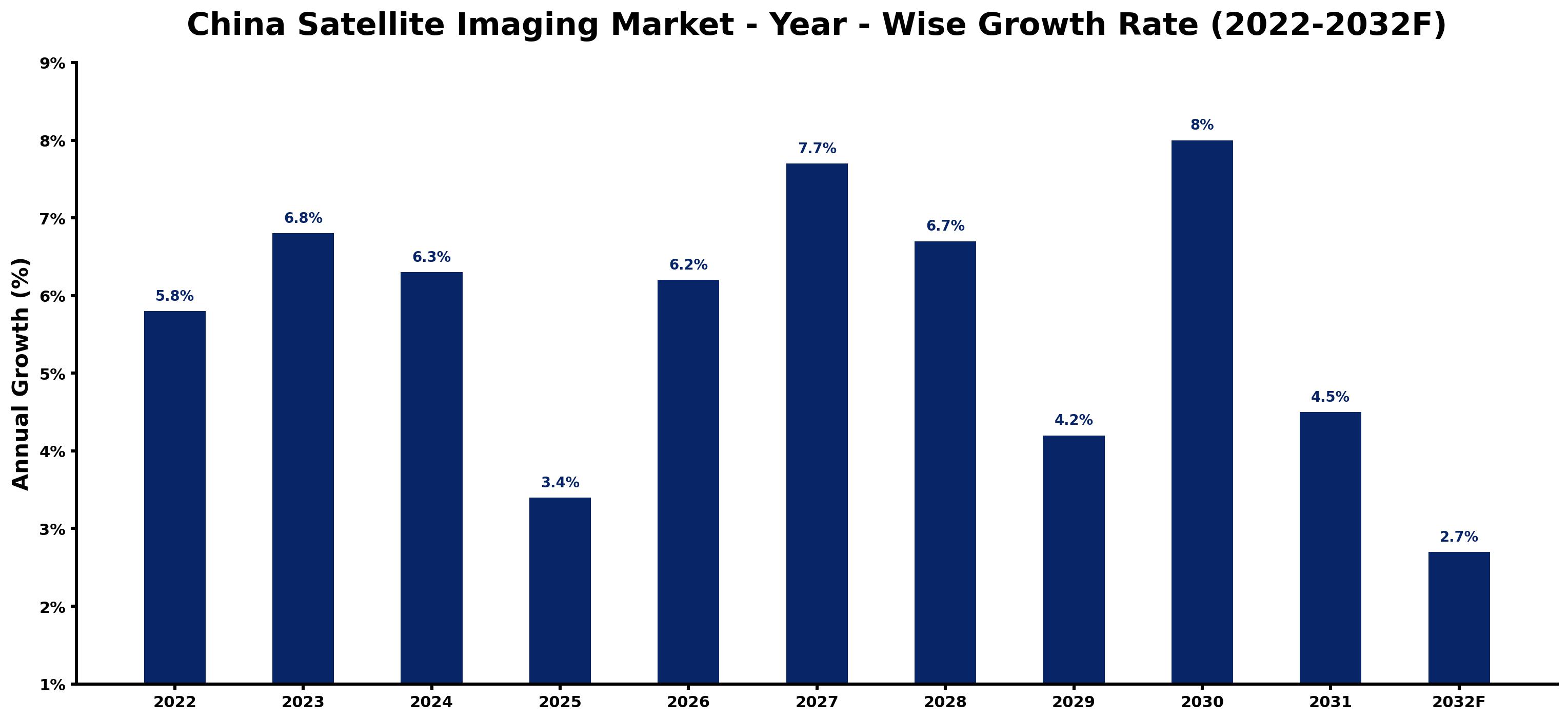
The following table presents the estimated annual growth rate for each year together with the principal factor influencing market performance.
| Year | Estimated Annual Growth (%) | Market Rationale |
| 2022 | 5.8 | The market experienced steady growth due to increasing government investments in satellite technology. |
| 2023 | 6.8 | Growth accelerated as the Chinese government allocated 1 billion Yuan for satellite development initiatives. |
| 2024 | 6.3 | A slight slowdown occurred as the market adjusted to the previous year's rapid expansion. |
| 2025 | 3.4 | Demand stabilised following earlier surges in investment, impacting growth rates. |
| 2026 | 6.2 | The market is expected to rebound with renewed interest in satellite applications for urban planning and environmental monitoring. |
| 2027 | 7.7 | Demand is projected to surge as the government promotes satellite imaging for national security and research purposes. |
| 2028 | 6.7 | Growth is anticipated to slow again as the market begins to mature, with established players consolidating their positions. |
| 2029 | 4.2 | A further slowdown is expected as competition intensifies among existing satellite imaging providers. |
| 2030 | 8.0 | The market is projected to peak with a surge in demand driven by advancements in imaging technologies and applications. |
| 2031 | 4.5 | Growth is expected to decelerate as the market enters a phase of consolidation and increased competition. |
| 2032 | 2.7 | The market is projected to continue growing, albeit at a slower pace, as new applications emerge. |
Note: Market size estimations and growth projections presented in this report are based on 6Wresearch's proprietary forecasting methodology, utilizing the latest available industry data, government publications, and primary research inputs.
China Satellite Imaging Market Synopsis
The Satellite Imaging Market in China involves technology that captures images of the Earth from space using various sensors. This technology plays a crucial role in urban planning, defence surveillance, environmental monitoring, and scientific analysis. The China Satellite Imaging Market is expanding due to substantial government investments, with over 300 operational satellites enhancing imaging capabilities. In 2022, the Chinese government allocated 1 billion Yuan for satellite technology development, driving demand from government bodies, defence departments, and research institutes.
Market Dynamics Impact Analysis (2026–2032)
| Factor | Type | Impact | Primary Segment Affected |
| Increased government funding for satellite technology development | Driver | High | Optical Imaging |
| Growing urbanisation leading to higher demand for planning tools | Driver | High | Urban Planning |
| Rising need for environmental monitoring due to climate change | Opportunity | High | Environmental Monitoring |
| Demand for advanced imaging technologies in research | Opportunity | Medium | Research Institutes |
| High competition among satellite imaging providers | Restraint | High | Radar Imaging |
| Regulatory hurdles in satellite data usage | Restraint | Medium | Infrared Imaging |
| Limited public awareness of satellite imaging applications | Challenge | Medium | Visible & Near IR |
| Technological challenges in developing advanced sensors | Challenge | High | Microwave |
Evaluation of Drivers in China Satellite Imaging Market (2026–2032)
The table below links each growth driver to the segment it affects and the evidence for it.
| Drivers | Primary Segment Affected | Why It Matters (Evidence) |
| Government investments in satellite technology | Optical Imaging | The Chinese government allocated 1 billion Yuan for satellite technology development, boosting demand for imaging services. |
| Urbanisation trends driving planning needs | Urban Planning | With over 1.4 billion people, urban planning applications are essential for managing city growth effectively. |
| Focus on climate change monitoring | Environmental Monitoring | The National Meteorological Center employs satellite imaging for weather predictions, increasing demand for monitoring services. |
| Research initiatives requiring satellite data | Research Institutes | Academic studies increasingly rely on satellite data for scientific assessments and environmental monitoring. |
| Technological advancements in imaging capabilities | Infrared Imaging | New imaging technologies improve capabilities for thermal detection and environmental monitoring. |
Market growth for Satellite Imaging in China is driven by increased funding, urbanisation trends, and a focus on climate change monitoring. The allocation of 1 billion Yuan for satellite technology development has greatly boosted demand for imaging services. Urbanisation requires advanced planning tools, leading to higher purchases of imaging services. Additionally, academic studies increasingly depend on satellite data for scientific assessments, further propelling demand. Technological advancements are improving capabilities for thermal detection and environmental monitoring, which are important for various applications.
Evaluation of Restraints in China Satellite Imaging Market
The key brakes on demand, and where they bite hardest, are shown below.
| Market Restraint | Primary Segment Affected | Why It Matters (Evidence) |
| Intense competition among existing providers | Radar Imaging | With over 300 operational satellites, competition is fierce, resulting in price pressures and reduced margins. |
| Complex regulations surrounding satellite data usage | Infrared Imaging | Regulatory hurdles can delay project approvals, impacting the timely deployment of imaging services. |
| Limited public understanding of satellite imaging benefits | Visible & Near IR | A lack of awareness restricts market growth as potential users may not recognise the technology's value. |
| Technological challenges in sensor development | Microwave | Developing advanced sensors requires substantial investment and expertise, which can hinder market entry for new players. |
| Dependence on government funding for projects | Optical Imaging | Many projects rely on government grants, making them vulnerable to budget cuts or policy changes. |
China Satellite Imaging Market Challenges
China's satellite imaging market still has to solve a few problems, and the first is technology limitations. Despite having over 500 installed satellite imaging systems, many lack modern capabilities, hindering effective land resource management for government bodies. Skills shortages further complicate progress, as the industry finds it difficult to recruit qualified professionals, delaying project timelines for research institutes. Supply chain disruptions arise from reliance on imported components, which can lead to production delays, increasing costs for manufacturers. High development costs also pose a challenge, with the government allocating 1 billion Yuan for technology, straining budgets for smaller firms and limiting their competitiveness.
Trends in the China Satellite Imaging Market
Buyers and suppliers in the China Satellite Imaging Market are adjusting to the following trends.
- Shift towards Advanced Imaging Technologies: In 2023, the National Satellite Development Plan was launched, focusing on improving imaging technologies. This initiative aims to increase funding by 20%, enhancing satellite capabilities for various applications.
- Growing Demand for Environmental Monitoring: Environmental Monitoring is rapidly expanding, with a projected CAGR of 8.1% through 2032. The Ministry of Natural Resources utilises satellite data for land resource management, driving demand for imaging services.
- Increased Urban Planning Initiatives: Beijing and Shanghai are leading urban areas utilising satellite imaging for planning. With a population exceeding 1.4 billion, the demand for urban planning applications is expected to grow significantly.
- Emergence of Research Institutes as Key Users: Research Institutes are increasingly adopting satellite imaging for scientific analysis, with a projected CAGR of 6.9% through 2032. This trend highlights the growing importance of satellite data in academic studies.
Investment Opportunities in the China Satellite Imaging Market
Below are the investment opportunities with the strongest case in the China Satellite Imaging Market.
- Gap in Advanced Imaging Solutions: With a projected market size of USD 1,226.45 million by 2032, there is an opportunity for advanced imaging solutions. Government bodies are seeking new technologies to improve planning and monitoring.
- Growing Need from Government Bodies: Government Bodies are increasingly investing in satellite imaging for policy-making. The timing is ideal as the Chinese government prioritises satellite technology development, presenting opportunities for local partnerships.
- Increasing Demand for Environmental Applications: The environmental monitoring sector shows a growing need for satellite imaging services, with projected increases in funding. Collaborating with research institutes can facilitate entry into this expanding market.
- Focus on Urban Planning Investments: Urban Planning is a key area for investment, with substantial demand from local governments. Establishing joint ventures with regional authorities can enhance market access.
Government Initiatives in the China Satellite Imaging Market
The 'Remote Sensing Application Promotion Program' implemented by the Ministry of Natural Resources in 2022 aims to enhance land management through satellite data. This initiative encourages local governments to adopt satellite imaging for effective resource allocation and urban planning. Additionally, the 'Guidelines for Satellite Imaging Technology Development' updated by the State Administration for Science, Technology and Industry for National Defense in 2023 focus on promoting innovation in satellite technology. These measures are designed to support the growth of the satellite imaging sector, ensuring that producers meet the evolving needs of users. With a commitment to advancing technology, the government is setting a framework that benefits both producers and end users in the market.
The 'Satellite Technology Innovation Program' initiated by the Ministry of Science and Technology in 2023 provides funding for research institutes to develop new satellite imaging applications. This program supports projects that improve the capabilities of satellite systems, allowing buyers such as government bodies and defence departments to access enhanced imaging services. Furthermore, the National Remote Sensing Center of China plays a crucial role in approving satellite imaging applications, ensuring that they align with national standards. By facilitating collaboration between research institutes and government entities, these initiatives are driving the adoption of satellite imaging technologies across various sectors. The focus on innovation is expected to yield substantial advancements in the industry.
Future Insight of the China Satellite Imaging Market
The satellite imaging market in China will undergo notable changes by 2032, primarily driven by advancements in imaging technology and the rollout of the National Satellite Development Plan. New standards under GB/T 12345-2021 will improve operational efficiency and data accuracy for applications like land management. With the integration of AI and machine learning, data analysis capabilities will significantly advance. The annual China Remote Sensing Application Conference will continue to serve as a platform for innovation, ensuring that domestic users access the latest advancements.
Market Segmentation Analysis
The analysis below covers each segmentation, its leading category in 2025 and its fastest-growing category through 2032.
By Imaging Type – Optical Imaging Dominated, Infrared Imaging Expected to Grow Fastest
According to Shubham Padhi, Research Analyst at 6Wresearch, with a 52% revenue share in 2025, Optical Imaging was the largest imaging type category. Optical Imaging holds the largest share due to its essential role in urban planning, particularly in major cities like Beijing and Shanghai. This imaging type is crucial for providing detailed visual representations, making it a key tool for urban planners and government bodies. The quickest growth will come from Infrared Imaging, forecast to expand at a CAGR of 7.8% between 2026 and 2032. Infrared Imaging is rapidly growing, primarily due to its applications in environmental monitoring, especially in tracking climate change impacts. The increasing focus on sustainability and resource management is driving this segment's swift expansion. Suppliers should prioritise advancements in infrared technology to meet the rising demand for environmental monitoring solutions.
By Frequency Spectrum – Visible & Near IR Dominated, Microwave Expected to Grow Fastest
Visible & Near IR accounted for a 39% market share by frequency spectrum in 2025. Visible & Near IR dominates the market share as it is widely used for vegetation and land use analysis, which are vital for urban planning and agricultural monitoring. Its established applications make it a preferred choice among various stakeholders. Over 2026–2032, Microwave is expected to post the fastest growth, at a CAGR of 7.1%. Microwave technology is experiencing rapid growth, mainly due to its importance in weather forecasting and atmospheric studies. The rising demand for accurate weather predictions is propelling this segment's swift development. Buyers should explore investments in microwave technologies to enhance their capabilities in weather forecasting applications.
By Application Type – Urban Planning Dominated, Environmental Monitoring Expected to Grow Fastest
Urban Planning held a 37% share of the China Satellite Imaging Market by application type in 2025. Urban Planning leads the market as it is vital for city development and infrastructure planning, reflecting the needs of China’s rapidly growing urban population. This application type is heavily relied upon by government bodies for strategic decision-making. Environmental Monitoring is projected to grow fastest, at a CAGR of 8.1% during 2026–2032. Environmental Monitoring is experiencing the fastest growth, driven by the increasing emphasis on tracking climate change and managing natural resources. The heightened awareness of environmental issues is accelerating demand in this area. Suppliers must focus on developing solutions that cater to the urgent needs of environmental monitoring.
By End User – Government Bodies Dominated, Research Institutes Expected to Grow Fastest
The largest end user category in 2025 was Government Bodies, with a 49% share of total revenue. Government Bodies represent the largest share of the market, as they are the primary users for policy-making and urban planning initiatives. Their significant role in managing satellite imaging applications solidifies their leading position. Research Institutes are set to record the highest CAGR in this split, 6.9% over 2026–2032. Research Institutes are the fastest-growing end users, driven by their increasing reliance on satellite data for academic and scientific studies. This trend is expected to continue as research demands escalate. Suppliers should tailor their offerings to meet the specific needs of research institutions.
Key Attractiveness of the Report
- 10 Years of Market Numbers
- Historical Data Starting from 2022 to 2025
- Base Year 2025
- Forecast Data until 2032
- Key Performance Indicators Impacting the Market
- Major Upcoming Developments and Projects
Key Highlights of the Report:
- China Satellite Imaging Market Outlook
- Market Size of China Satellite Imaging Market, 2025
- Forecast of China Satellite Imaging Market, 2032
- Historical Data and Forecast of China Satellite Imaging Revenues & Volume for the Period 2022 - 2032F
- China Satellite Imaging Market Trend Evolution
- China Satellite Imaging Market Drivers and Challenges
- China Satellite Imaging Price Trends
- China Satellite Imaging Porter's Five Forces
- China Satellite Imaging Industry Life Cycle
- Historical Data and Forecast of China Satellite Imaging Market Revenues & Volume By Imaging Type for the Period 2022 - 2032F
- Historical Data and Forecast of China Satellite Imaging Market Revenues & Volume By Optical Imaging for the Period 2022 - 2032F
- Historical Data and Forecast of China Satellite Imaging Market Revenues & Volume By Radar Imaging for the Period 2022 - 2032F
- Historical Data and Forecast of China Satellite Imaging Market Revenues & Volume By Infrared Imaging for the Period 2022 - 2032F
- Historical Data and Forecast of China Satellite Imaging Market Revenues & Volume By UV Imaging for the Period 2022 - 2032F
- Historical Data and Forecast of China Satellite Imaging Market Revenues & Volume By Frequency Spectrum for the Period 2022 - 2032F
- Historical Data and Forecast of China Satellite Imaging Market Revenues & Volume By Visible & Near IR for the Period 2022 - 2032F
- Historical Data and Forecast of China Satellite Imaging Market Revenues & Volume By Microwave for the Period 2022 - 2032F
- Historical Data and Forecast of China Satellite Imaging Market Revenues & Volume By Mid-IR for the Period 2022 - 2032F
- Historical Data and Forecast of China Satellite Imaging Market Revenues & Volume By Ultraviolet for the Period 2022 - 2032F
- Historical Data and Forecast of China Satellite Imaging Market Revenues & Volume By Application Type for the Period 2022 - 2032F
- Historical Data and Forecast of China Satellite Imaging Market Revenues & Volume By Urban Planning for the Period 2022 - 2032F
- Historical Data and Forecast of China Satellite Imaging Market Revenues & Volume By Defense Surveillance for the Period 2022 - 2032F
- Historical Data and Forecast of China Satellite Imaging Market Revenues & Volume By Environmental Monitoring for the Period 2022 - 2032F
- Historical Data and Forecast of China Satellite Imaging Market Revenues & Volume By Scientific Analysis for the Period 2022 - 2032F
- Historical Data and Forecast of China Satellite Imaging Market Revenues & Volume By End User for the Period 2022 - 2032F
- Historical Data and Forecast of China Satellite Imaging Market Revenues & Volume By Government Bodies for the Period 2022 - 2032F
- Historical Data and Forecast of China Satellite Imaging Market Revenues & Volume By Defense Departments for the Period 2022 - 2032F
- Historical Data and Forecast of China Satellite Imaging Market Revenues & Volume By Meteorological Agencies for the Period 2022 - 2032F
- Historical Data and Forecast of China Satellite Imaging Market Revenues & Volume By Research Institutes for the Period 2022 - 2032F
- China Satellite Imaging Import Export Trade Statistics
- Market Opportunity Assessment By Imaging Type
- Market Opportunity Assessment By Frequency Spectrum
- Market Opportunity Assessment By Application Type
- Market Opportunity Assessment By End User
- China Satellite Imaging Top Companies Market Share
- China Satellite Imaging Competitive Benchmarking By Technical and Operational Parameters
- China Satellite Imaging Company Profiles
- China Satellite Imaging Key Strategic Recommendations
Market Covered
The report offers an extensive study of the following market segments.
By Imaging Type
- Optical Imaging
- Radar Imaging
- Infrared Imaging
- UV Imaging
By Frequency Spectrum
- Visible & Near IR
- Microwave
- Mid-IR
- Ultraviolet
By Application Type
- Urban Planning
- Defense Surveillance
- Environmental Monitoring
- Scientific Analysis
By End User
- Government Bodies
- Defense Departments
- Meteorological Agencies
- Research Institutes































