India Satellite Mapping Market Size & Growth Rate
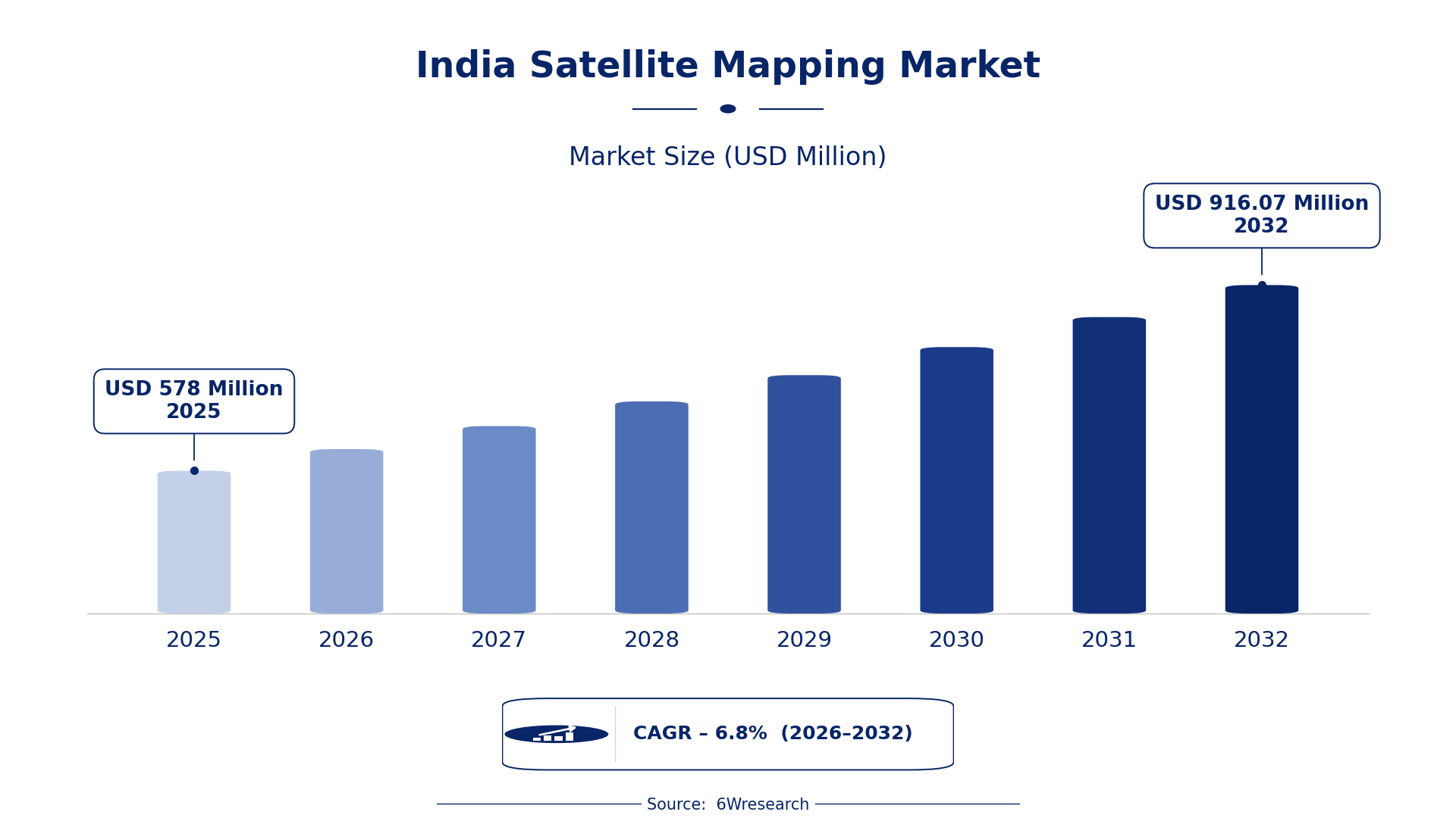
According to 6Wresearch internal database and industry insights, the India Satellite Mapping Market was valued at USD 578.0 million in 2025 and is projected to reach USD 916.07 million by 2032, growing at a CAGR of approximately 6.8% during 2026–2032.
India Satellite Mapping Market Highlights
| Report Metric | Details |
| Report Name | India Satellite Mapping Market |
| Market Size 2025 | USD 578.0 million |
| Market Size 2032 | USD 916.07 million |
| Absolute Growth 2025–2032 | USD 338.07 million |
| CAGR 2026–2032 | 6.8% |
| Peak Annual Growth | 9.2% in 2027 |
| Forecast Period | 2026–2032 |
| Historical Data | 2022–2025 |
| Base Year | 2025 |
| Leading Mapping Type, 2025 | Topographic Mapping (47% share) |
| Leading Data Source, 2025 | Optical Imagery (35% share) |
| Leading Output Format, 2025 | Digital Elevation Maps (46% share) |
| Leading End User, 2025 | Civil Engineering Firms (35% share) |
| Fastest-Growing Mapping Type | Geospatial Analytics (8.2% CAGR) |
| Fastest-Growing Data Source | Multispectral Data (9.3% CAGR) |
| Fastest-Growing Output Format | GIS Format (9.4% CAGR) |
| Fastest-Growing End User | Environmental Scientists (9.4% CAGR) |
| Growing Sector | Urban Planning |
| Key End Users | Civil Engineering Firms, Urban Planners, Environmental Scientists |
India Satellite Mapping Market Year-wise Growth Rate and Key Drivers (2022–2032)
This graph illustrates the annual growth rates of the market from 2022 to 2032, highlighting a steady upward trajectory and projected market expansion over the forecast period.
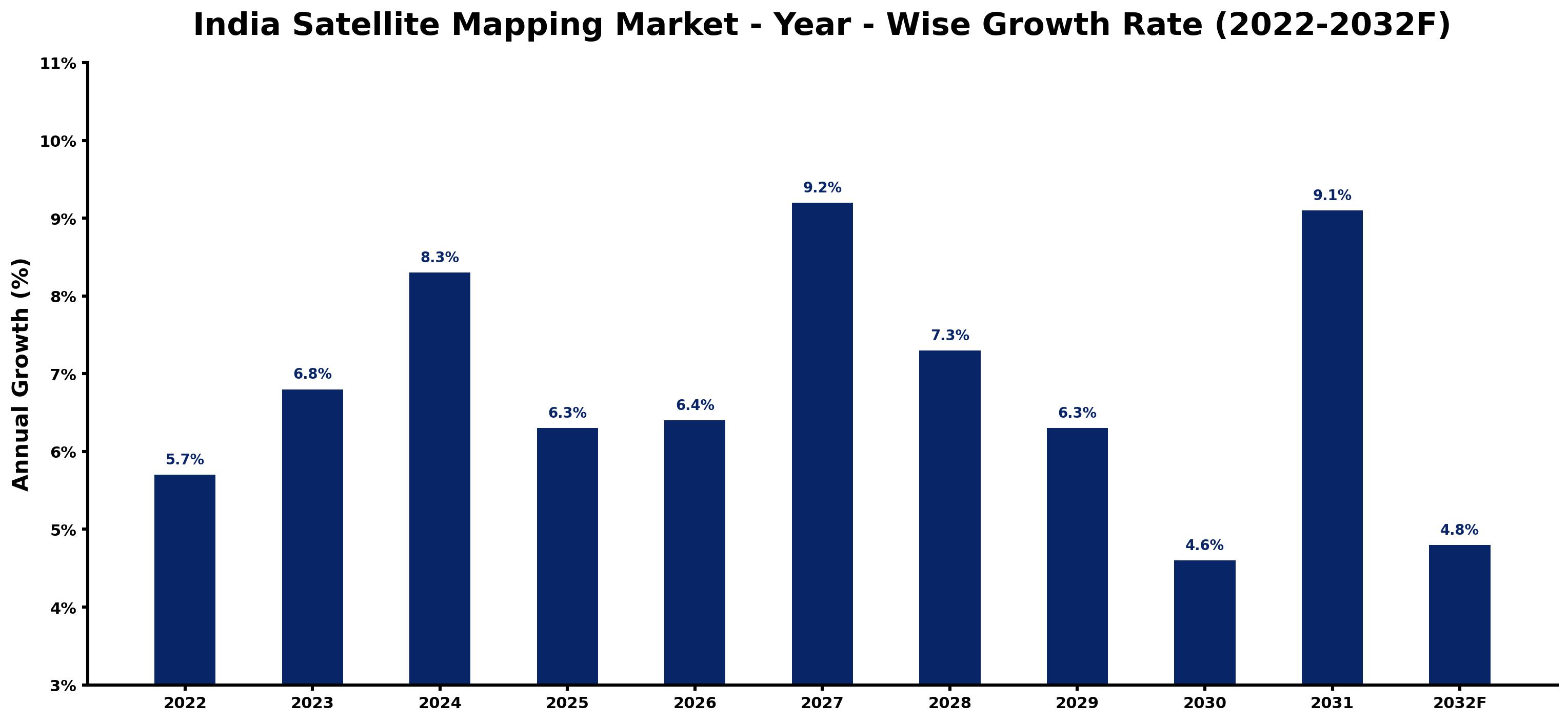
Below, each year's estimated growth is shown next to the factor that most influenced it.
| Year | Estimated Annual Growth (%) | Market Rationale |
| 2022 | 5.7 | The market experienced steady growth due to urban planning demands from government agencies like the Smart Cities Mission. |
| 2023 | 6.8 | Demand accelerated with the Smart Cities Mission focusing on infrastructure improvements in urban areas. |
| 2024 | 8.3 | Growth continued as topographic mapping became essential for disaster management in the Himalayan region. |
| 2025 | 6.3 | The growth rate slowed as projects under the Atal Mission for Rejuvenation and Urban Transformation progressed. |
| 2026 | 6.4 | Demand is expected to rise again as the National Remote Sensing Centre updates its data sharing policies. |
| 2027 | 9.2 | The market is projected to peak as satellite data usage expands across various sectors, driven by the Digital India initiative. |
| 2028 | 7.3 | Growth is expected to slow as the market adjusts to rapid technological advancements in satellite mapping. |
| 2029 | 6.3 | Demand will continue to moderate as buyers evaluate the costs and benefits of satellite mapping technologies in urban planning. |
| 2030 | 4.6 | The market is projected to see further slowdown as buyers await new satellite launches and data availability. |
| 2031 | 9.1 | A resurgence in growth is expected as investment in satellite technology increases, particularly in urban infrastructure. |
| 2032 | 4.8 | The market growth rate is projected to slow again as the focus shifts to data integration and analysis. |
Note: Market size estimations and growth projections presented in this report are based on 6Wresearch's proprietary forecasting methodology, utilizing the latest available industry data, government publications, and primary research inputs.
India Satellite Mapping Market Synopsis
The India Satellite Mapping Market encompasses the use of satellite imagery to create detailed maps and analyses of the Earth's surface. This technology is essential for urban planning, environmental monitoring, and resource management. The market is growing due to increasing urbanisation, with over 1.3 billion people driving demand for infrastructure development. Initiatives like the Smart Cities Mission and the Digital India initiative contribute to this growth by utilising satellite mapping data for improved urban services and infrastructure planning.
Market Dynamics Impact Analysis (2026–2032)
| Factor | Type | Impact | Primary Segment Affected |
| Increasing urbanisation drives demand for efficient urban planning solutions. | Driver | High | Land Use Mapping |
| The need for accurate data in disaster management creates opportunities for satellite mapping services. | Opportunity | High | Topographic Mapping |
| High costs of satellite technology limit access for smaller firms. | Restraint | Medium | Geospatial Analytics |
| Limited awareness of satellite mapping benefits restrains market growth. | Restraint | Medium | Climate Mapping |
| Technological advancements in satellite imagery create new demand. | Driver | High | Optical Imagery |
| The growing focus on environmental monitoring opens new avenues for satellite mapping. | Opportunity | High | Environmental Scientists |
| Regulatory hurdles can delay project approvals for satellite mapping applications. | Challenge | Medium | Civil Engineering Firms |
| Dependence on government funding for projects can lead to market volatility. | Challenge | Medium | Urban Planners |
Evaluation of Drivers in India Satellite Mapping Market (2026–2032)
The main growth drivers and the segments they affect most are set out below.
| Drivers | Primary Segment Affected | Why It Matters (Evidence) |
| Rising urbanisation increases demand for satellite mapping in city planning. | Land Use Mapping | India's population growth necessitates advanced urban planning solutions, leading to increased purchases of mapping services. |
| Technological advancements improve satellite imagery quality and accessibility. | Optical Imagery | The launch of over 300 satellites by India boosts the availability of high-resolution data for mapping. |
| Government initiatives promote the integration of satellite mapping in infrastructure development. | Topographic Mapping | The Smart Cities Mission encourages local governments to adopt satellite mapping for urban infrastructure projects. |
| The agricultural sector increasingly utilises satellite mapping for crop management. | Geospatial Analytics | India's agricultural growth drives demand for precise monitoring of crop health and land use. |
| Environmental monitoring efforts expand the use of satellite mapping technologies. | Climate Mapping | The National Biodiversity Action Plan emphasises the need for satellite data in conservation efforts. |
The demands of urban planning are escalating as the population surpasses 1.3 billion, resulting in higher purchases of mapping services. The launch of over 300 satellites improves the availability of high-resolution data, enabling better decision-making. Furthermore, the agricultural sector's requirement for accurate monitoring of crop health boosts the demand for satellite mapping technologies, while environmental monitoring efforts broaden the application of these solutions.
Evaluation of Restraints in India Satellite Mapping Market
Below mentioned are some major restraints and their influence on market dynamics.
| Market Restraint | Primary Segment Affected | Why It Matters (Evidence) |
| High costs of satellite technology limit access for smaller firms. | Geospatial Analytics | Smaller firms struggle to invest in advanced satellite mapping tools, hindering their market participation. |
| Limited awareness of satellite mapping benefits restrains market growth. | Climate Mapping | Many potential users do not fully understand the advantages of satellite mapping for environmental monitoring. |
| Regulatory hurdles can delay project approvals for satellite mapping applications. | Civil Engineering Firms | Complex approval processes slow down the implementation of satellite mapping in infrastructure projects. |
| Dependence on government funding for projects can lead to market volatility. | Urban Planners | Fluctuations in government budgets affect the consistency of satellite mapping project funding. |
| Data privacy concerns can limit the use of satellite mapping technologies. | Topographic Mapping | Regulatory scrutiny over data usage may deter firms from adopting satellite mapping solutions. |
India Satellite Mapping Market Challenges
Rising costs in the India Satellite Mapping Market challenge producers, who must invest heavily in advanced technology to stay competitive, which can squeeze profit margins. This financial strain arises from a crowded market where numerous firms compete for government contracts, making profitability difficult. Buyers, particularly government agencies, face increased expenses for satellite imagery, with costs rising by approximately 20% due to the need for high-quality data. Skills shortages in satellite data analysis impede firms from effectively utilising available technology, delaying project timelines and affecting service delivery for urban planners and environmental researchers.
Trends in the India Satellite Mapping Market
Below mentioned are some of the trends shaping the India Satellite Mapping Market growth.
- Shift from Traditional Mapping to Satellite-Based Solutions: As of 2023, the launch of over 300 satellites by India is reshaping mapping practices, leading to a greater reliance on satellite data for urban planning.
- Emergence of Multispectral Data for Detailed Analysis: The increasing use of multispectral data, with a CAGR of 9.3%, is enabling more thorough land-use analysis, especially in agriculture and environmental monitoring.
- Increased Integration of GIS Formats in Mapping: The rise of GIS formats, projected to grow at 9.4%, is improving data analysis capabilities for urban planners and environmental scientists.
- Focus on Climate Mapping for Environmental Studies: The National Biodiversity Action Plan's focus on climate mapping is boosting the demand for satellite data to track environmental changes.
Investment Opportunities in the India Satellite Mapping Market
Some of the investment opportunities in the India Satellite Mapping Market are mentioned below.
- Investment in Urban Infrastructure Projects: The Smart Cities Mission is driving the need for advanced satellite mapping solutions, with an estimated investment of USD 1.2 billion by 2025. This offers an opportunity for firms to provide mapping services to urban planners and local governments, aiding improved infrastructure development.
- Supply of Agricultural Monitoring Solutions: With the agricultural sector's growing dependence on satellite mapping for crop management, the Pradhan Mantri Krishi Sinchai Yojana allocates USD 500 million for water resource management. Suppliers can collaborate with agricultural planners to deliver customised mapping solutions that boost productivity.
- Expansion of Environmental Monitoring Capabilities: The National Biodiversity Action Plan underscores the need for satellite mapping in conservation efforts, with a budget of USD 300 million set aside for 2024. This opens doors for firms to offer mapping services to environmental scientists and NGOs focused on biodiversity.
- Development of a leading supplier Analytics Tools: The increasing demand for geospatial analytics, projected to rise by 8.2% annually, presents opportunities for technology providers. Partnering with civil engineering firms can improve project planning and execution through advanced analytics derived from satellite mapping data.
Government Initiatives in the India Satellite Mapping Market
The Digital India initiative, launched in 2015, promotes the use of satellite data for urban infrastructure improvements. This initiative encourages the integration of satellite mapping technologies to improve service delivery in urban areas. Additionally, the Atal Mission for Rejuvenation and Urban Transformation (AMRUT) emphasises satellite data for urban planning, with ongoing projects since 2020 aimed at improving infrastructure. These measures collectively enhance access to satellite mapping for various stakeholders, including government agencies and private firms.
The National Remote Sensing Centre plays a key role in approving satellite data services and enhancing access to satellite mapping data. In 2022, the Centre updated its data sharing policy to facilitate better access for researchers and policymakers. Furthermore, the Pradhan Mantri Krishi Sinchai Yojana promotes the use of satellite mapping for efficient water resource management in agriculture, supporting farmers and agricultural planners. These initiatives ensure that satellite mapping remains integral to various sectors, including agriculture and urban planning.
Future Insight of the India Satellite Mapping Market
The India Satellite Mapping Market is set for transformative changes by 2032, driven by advancements in satellite technology and data processing. The Indian Space Research Organisation is expected to launch over 100 new satellites, increasing data availability for urban planning and environmental monitoring. The Smart Cities Mission will increasingly depend on satellite mapping to enhance infrastructure development across urban areas. Additionally, the agricultural sector will benefit from improved crop monitoring capabilities, enabling better resource management and allocation.
Market Segmentation Analysis
The report offers a comprehensive study of the following market segments and their leading categories in the market.
By Mapping Type – Topographic Mapping Dominated, Geospatial Analytics Expected to Grow Fastest
According to Shubham Padhi, Research Analyst at 6Wresearch, the largest mapping type category in 2025 was Topographic Mapping, with a 47% share of total revenue. Topographic mapping holds the largest share due to its critical role in understanding terrain features, especially in the Himalayan region where disaster management is paramount. Government agencies and private firms rely heavily on this segment for urban planning and infrastructure projects, reinforcing its significance in India. Over 2026–2032, Geospatial Analytics is expected to post the fastest growth, at a CAGR of 8.2%. The increasing focus on data-driven decision-making across sectors such as agriculture and environmental monitoring is propelling this segment forward. Suppliers should focus on enhancing analytical capabilities to meet the rising demand from various sectors.
By Data Source – Optical Imagery Dominated, Multispectral Data Expected to Grow Fastest
Optical Imagery accounted for a 35% market share by data source in 2025. Optical imagery commands the largest share in the market as it is widely used for capturing high-resolution images of the Earth, which are crucial for urban planning and environmental monitoring. Its prominent application by the National Remote Sensing Centre highlights its importance in satellite mapping efforts across India. Multispectral Data is projected to grow fastest, at a CAGR of 9.3% during 2026–2032. Multispectral data is witnessing rapid growth as it allows for detailed analysis of different wavelengths, which is essential for land use and agricultural monitoring. The increasing emphasis on precision agriculture and environmental studies is driving this segment's expansion. Buyers should seek advanced multispectral data solutions to enhance their analytical capabilities across various applications.
By Output Format – Digital Elevation Maps Dominated, GIS Format Expected to Grow Fastest
In 2025, Digital Elevation Maps led the output format split with a 46% share. Digital elevation maps dominate the market as they are vital for topographic analysis and engineering projects, providing essential data for infrastructure development. Their extensive use by civil engineering firms underscores their importance in the satellite mapping sector. The quickest growth will come from GIS Format, forecast to expand at a CAGR of 9.4% between 2026 and 2032. GIS format is rapidly gaining traction as it effectively integrates and analyses spatial data, making it essential for numerous applications. The growing need for comprehensive data analysis in urban planning and environmental monitoring is fuelling this segment's growth. Suppliers must invest in GIS technology to satisfy the increasing demand for integrated spatial data solutions.
By End User – Civil Engineering Firms Dominated, Environmental Scientists Expected to Grow Fastest
Civil Engineering Firms held a 35% share of the India Satellite Mapping Market by end user in 2025. Civil engineering firms represent the largest share of the market as they are major users of satellite mapping for infrastructure development projects across India. Their reliance on accurate mapping data for planning and execution solidifies their position as the leading end user. Environmental Scientists are set to record the highest CAGR in this split, 9.4% over 2026–2032. Environmental scientists are the fastest-growing segment, driven by the increasing need for research and monitoring of environmental changes. The heightened focus on sustainability and conservation efforts is accelerating demand for satellite mapping in this sector. Suppliers should tailor their offerings to meet the specific needs of environmental scientists, capitalising on the growth in this segment.
Key Attractiveness of the Report
- 10 Years of Market Numbers
- Historical Data Starting from 2022 to 2025
- Base Year 2025
- Forecast Data until 2032
- Key Performance Indicators Impacting the Market
- Major Upcoming Developments and Projects
Key Highlights of the Report:
- India Satellite Mapping Market Outlook
- Market Size of India Satellite Mapping Market, 2025
- Forecast of India Satellite Mapping Market, 2032
- Historical Data and Forecast of India Satellite Mapping Revenues & Volume for the Period 2022 - 2032F
- India Satellite Mapping Market Trend Evolution
- India Satellite Mapping Market Drivers and Challenges
- India Satellite Mapping Price Trends
- India Satellite Mapping Porter's Five Forces
- India Satellite Mapping Industry Life Cycle
- Historical Data and Forecast of India Satellite Mapping Market Revenues & Volume By Mapping Type for the Period 2022 - 2032F
- Historical Data and Forecast of India Satellite Mapping Market Revenues & Volume By Topographic Mapping for the Period 2022 - 2032F
- Historical Data and Forecast of India Satellite Mapping Market Revenues & Volume By Land Use Mapping for the Period 2022 - 2032F
- Historical Data and Forecast of India Satellite Mapping Market Revenues & Volume By Geospatial Analytics for the Period 2022 - 2032F
- Historical Data and Forecast of India Satellite Mapping Market Revenues & Volume By Climate Mapping for the Period 2022 - 2032F
- Historical Data and Forecast of India Satellite Mapping Market Revenues & Volume By Data Source for the Period 2022 - 2032F
- Historical Data and Forecast of India Satellite Mapping Market Revenues & Volume By Optical Imagery for the Period 2022 - 2032F
- Historical Data and Forecast of India Satellite Mapping Market Revenues & Volume By Multispectral Data for the Period 2022 - 2032F
- Historical Data and Forecast of India Satellite Mapping Market Revenues & Volume By SAR + Optical for the Period 2022 - 2032F
- Historical Data and Forecast of India Satellite Mapping Market Revenues & Volume By Hyperspectral for the Period 2022 - 2032F
- Historical Data and Forecast of India Satellite Mapping Market Revenues & Volume By Output Format for the Period 2022 - 2032F
- Historical Data and Forecast of India Satellite Mapping Market Revenues & Volume By Digital Elevation Maps for the Period 2022 - 2032F
- Historical Data and Forecast of India Satellite Mapping Market Revenues & Volume By GIS Format for the Period 2022 - 2032F
- Historical Data and Forecast of India Satellite Mapping Market Revenues & Volume By Analytical Reports for the Period 2022 - 2032F
- Historical Data and Forecast of India Satellite Mapping Market Revenues & Volume By Satellite Models for the Period 2022 - 2032F
- Historical Data and Forecast of India Satellite Mapping Market Revenues & Volume By End User for the Period 2022 - 2032F
- Historical Data and Forecast of India Satellite Mapping Market Revenues & Volume By Civil Engineering Firms for the Period 2022 - 2032F
- Historical Data and Forecast of India Satellite Mapping Market Revenues & Volume By Urban Planners for the Period 2022 - 2032F
- Historical Data and Forecast of India Satellite Mapping Market Revenues & Volume By Mining Industry for the Period 2022 - 2032F
- Historical Data and Forecast of India Satellite Mapping Market Revenues & Volume By Environmental Scientists for the Period 2022 - 2032F
- India Satellite Mapping Import Export Trade Statistics
- Market Opportunity Assessment By Mapping Type
- Market Opportunity Assessment By Data Source
- Market Opportunity Assessment By Output Format
- Market Opportunity Assessment By End User
- India Satellite Mapping Top Companies Market Share
- India Satellite Mapping Competitive Benchmarking By Technical and Operational Parameters
- India Satellite Mapping Company Profiles
- India Satellite Mapping Key Strategic Recommendations
Market Covered
Segments analysed in this report are listed below.
By Mapping Type
- Topographic Mapping
- Land Use Mapping
- Geospatial Analytics
- Climate Mapping
By Data Source
- Optical Imagery
- Multispectral Data
- SAR + Optical
- Hyperspectral
By Output Format
- Digital Elevation Maps
- GIS Format
- Analytical Reports
- Satellite Models
By End User
- Civil Engineering Firms
- Urban Planners
- Mining Industry
- Environmental Scientists































