India Topographic Mapping Market Size & Growth Rate
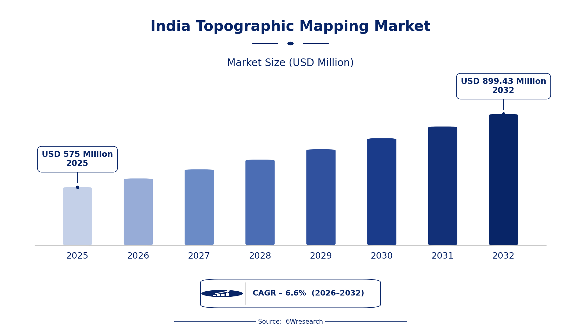
According to 6Wresearch internal database and industry insights, the India Topographic Mapping Market was valued at USD 575.0 million in 2025 and is projected to reach USD 899.43 million by 2032, growing at a CAGR of approximately 6.6% during 2026–2032.
India Topographic Mapping Market Highlights
| Report Metric | Details |
| Report Name | India Topographic Mapping Market |
| Market Size 2025 | USD 575.0 million |
| Market Size 2032 | USD 899.43 million |
| Absolute Growth 2025–2032 | USD 324.43 million |
| CAGR 2026–2032 | 6.6% |
| Peak Annual Growth | 8.5% in 2032 |
| Forecast Period | 2026–2032 |
| Historical Data | 2022–2025 |
| Base Year | 2025 |
| Leading Topographic Mapping, 2025 | Satellite DEM Mapping (48% share) |
| Leading Product Type, 2025 | DEM Generation (44% share) |
| Leading Technique, 2025 | LiDAR (47% share) |
| Leading Distribution Channel, 2025 | Remote Sensing Services (41% share) |
| Leading End User Industry, 2025 | Construction & Surveying (33% share) |
| Fastest-Growing Topographic Mapping | Drone-Based Mapping (8.0% CAGR) |
| Fastest-Growing Product Type | UAV LIDAR Systems (7.7% CAGR) |
| Fastest-Growing Distribution Channel | GIS Solution Providers (9.1% CAGR) |
| Fastest-Growing End User Industry | Environmental Analysis (8.8% CAGR) |
| Growing Sector | Environmental Analysis |
| Key End Users | Construction & Surveying, Geography/Planning, Civil Engineering Firms, Environmental Analysis |
India Topographic Mapping Market Year-wise Growth Rate and Key Drivers (2022–2032)
This graph illustrates the annual growth rates of the market from 2022 to 2032, highlighting a steady upward trajectory and projected market expansion over the forecast period.
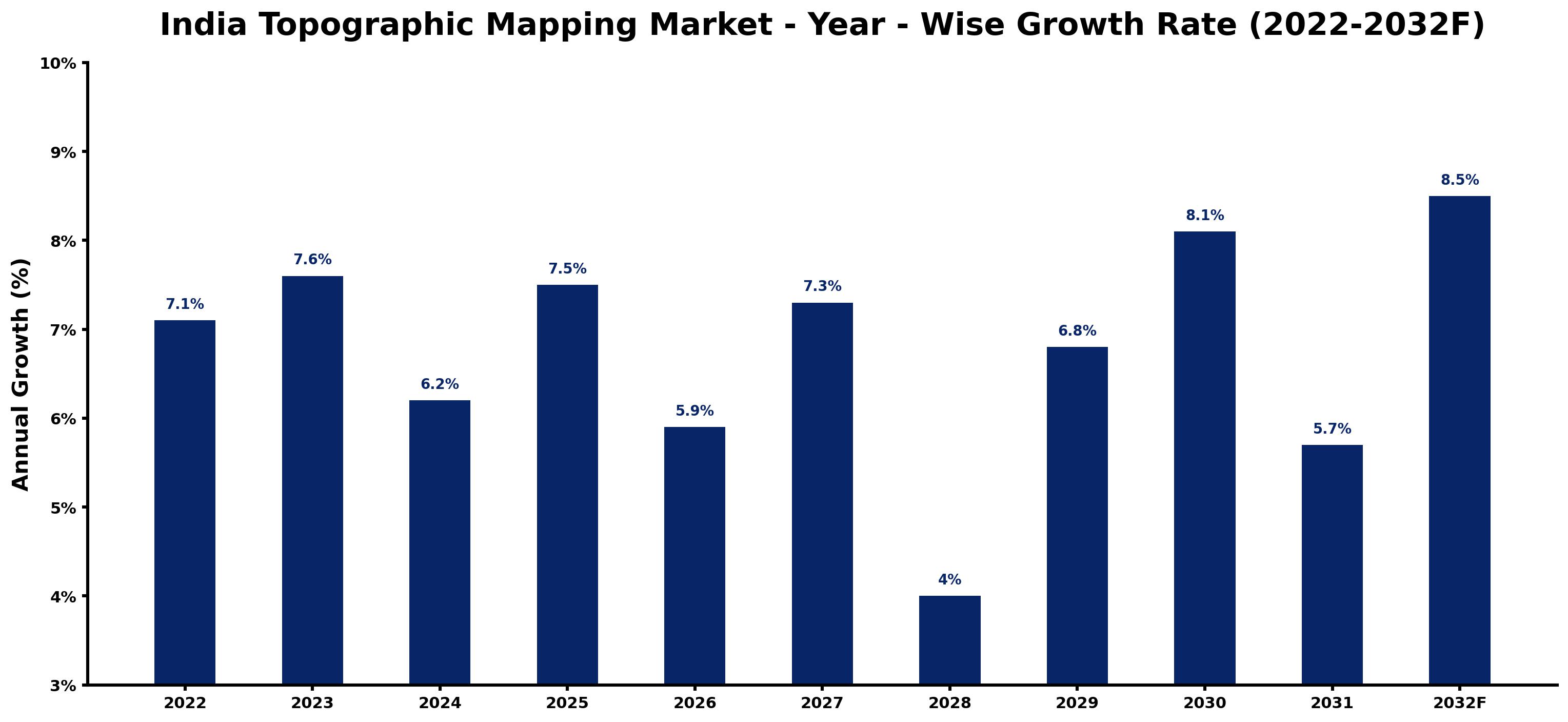
The following table presents the estimated annual growth rate for each year together with the principal factor influencing market performance.
| Year | Estimated Annual Growth (%) | Market Rationale |
| 2022 | 7.1 | Urban planning initiatives increased demand for accurate mapping services. |
| 2023 | 7.6 | The Smart Cities Mission spurred growth in topographic mapping projects. |
| 2024 | 6.2 | Growth slowed as some urban projects faced budget constraints. |
| 2025 | 7.5 | Demand rose again with new construction projects across urban areas. |
| 2026 | 5.9 | A slowdown is expected due to delays in project approvals and funding. |
| 2027 | 7.3 | Increased adoption of UAV LIDAR systems boosted mapping accuracy. |
| 2028 | 4.0 | Growth is projected to slow as the market adjusts to new technology standards. |
| 2029 | 6.8 | Demand surged with rising environmental analysis projects in urban areas. |
| 2030 | 8.1 | The construction sector's expansion will lead to increased mapping needs. |
| 2031 | 5.7 | Growth is expected to slow as some projects face regulatory hurdles. |
| 2032 | 8.5 | A peak in demand is projected as urban development accelerates. |
Note: Market size estimations and growth projections presented in this report are based on 6Wresearch's proprietary forecasting methodology, utilizing the latest available industry data, government publications, and primary research inputs.
India Topographic Mapping Market Synopsis
Topographic Mapping in India involves creating detailed representations of the Earth's surface using technologies like satellite imagery and LiDAR. This mapping is essential for urban planning, environmental analysis, and construction projects. The India Topographic Mapping Market is growing due to rising demand from the construction sector and government initiatives like the Smart Cities Mission. With over 1.3 billion people, the need for accurate mapping is critical for effective urban development. Investments in UAV LIDAR systems and GIS platforms further drive this market's expansion.
Market Dynamics Impact Analysis (2026–2032)
| Factor | Type | Impact | Primary Segment Affected |
| Growing urban population increases the need for accurate mapping services. | Driver | High | Construction & Surveying |
| Government initiatives promote the use of geospatial data for urban planning. | Driver | High | Geography/Planning |
| Investment in UAV LIDAR systems presents opportunities for enhanced mapping accuracy. | Opportunity | High | UAV LIDAR Systems |
| The rise of environmental analysis projects creates demand for topographic mapping. | Opportunity | High | Environmental Analysis |
| Budget constraints may limit project funding for mapping services. | Restraint | Medium | Construction & Surveying |
| Delays in project approvals can hinder timely mapping services. | Restraint | Medium | Geography/Planning |
| Technological integration challenges can slow down mapping processes. | Challenge | High | UAV LIDAR Systems |
| Regulatory hurdles may complicate the approval of mapping projects. | Challenge | Medium | Environmental Analysis |
Evaluation of Drivers in India Topographic Mapping Market (2026–2032)
The factors lifting demand, and the evidence behind each, are summarised below.
| Drivers | Primary Segment Affected | Why It Matters (Evidence) |
| Increasing urbanisation drives demand for precise mapping. | Construction & Surveying | With over 1.3 billion people, urban planning requires accurate topographic data. |
| Government initiatives promote the use of geospatial data. | Geography/Planning | The National Geospatial Policy 2021 encourages better mapping practices across sectors. |
| Adoption of UAV LIDAR systems improves survey accuracy. | UAV LIDAR Systems | The growing use of UAV LIDAR in urban areas provides detailed mapping capabilities. |
| Expansion of the construction sector boosts mapping needs. | Construction & Surveying | India's construction sector is projected to grow, increasing mapping demand. |
| GIS platform usage is rising in government projects. | GIS Platforms | Numerous government projects are utilising GIS platforms for spatial data management. |
The urban population exceeding 1.3 billion drives demand for precise mapping services, particularly in urban planning. The construction sector is projected to grow, increasing the need for topographic mapping. The adoption of UAV LIDAR systems improves survey accuracy, leading to more detailed mapping capabilities.
Evaluation of Restraints in India Topographic Mapping Market
The key brakes on demand, and where they bite hardest, are shown below.
| Market Restraint | Primary Segment Affected | Why It Matters (Evidence) |
| Budget constraints limit funding for mapping projects. | Construction & Surveying | The construction sector's financial limitations can delay mapping initiatives. |
| Delays in project approvals hinder timely mapping services. | Geography/Planning | Regulatory processes can slow down the initiation of mapping projects. |
| Technological integration challenges slow down mapping processes. | UAV LIDAR Systems | Incompatibility with existing systems can delay UAV LIDAR implementation. |
| Regulatory hurdles complicate project approvals for mapping. | Environmental Analysis | Stringent regulations can prolong the approval process for mapping projects. |
| Limited awareness of advanced mapping technologies affects adoption. | Software Tools | Some sectors may hesitate to invest in new mapping technologies due to lack of knowledge. |
India Topographic Mapping Market Challenges
The India Topographic Mapping Market faces practical challenges, with regulatory hurdles being a primary concern that delays project approvals. Complex compliance requirements can extend timelines by up to 30%, affecting urban planners who depend on timely data. Technological limitations can impede progress, as outdated surveying methods may lead to inaccuracies, costing construction firms substantial rework expenses. Rising costs of advanced mapping technologies can strain budgets, compelling buyers to allocate up to 20% more for essential tools. Furthermore, buyers encounter difficulties in accessing reliable data, which can result in project delays and inefficiencies in urban development.
Trends in the India Topographic Mapping Market
Four trends stand out in the India Topographic Mapping Market.
- Shift from Traditional Mapping to UAV-Based Solutions: UAV-based mapping solutions are gaining traction in India, particularly in urban areas. The adoption of UAV LIDAR systems has increased, with a projected growth rate of 7.7% from 2026 to 2032.
- Transition from Ground Surveys to Remote Sensing: Remote sensing is becoming the preferred method for topographic mapping in India. The National Remote Sensing Centre supports satellite mapping initiatives, enhancing data collection across various sectors.
- Emergence of Advanced Mapping Software: Advanced mapping software is increasingly being adopted by civil engineering firms in India. The integration of these tools is essential for effective project management and planning, with significant growth in usage.
- Rise in Environmental Analysis Projects: Environmental analysis projects are driving demand for topographic mapping services. The National Green Tribunal supports these initiatives, highlighting the importance of accurate mapping in environmental management.
Investment Opportunities in the India Topographic Mapping Market
Below are the investment opportunities with the strongest case in the India Topographic Mapping Market.
- Partnerships with Local Firms for UAV Services: Now is the ideal time to partner with local firms for UAV mapping services. The increasing adoption of UAV LIDAR systems presents a strong opportunity for growth in urban areas.
- Invest in Advanced a leading supplier: Investment in advanced mapping technologies is timely as demand rises. Civil engineering firms are increasingly seeking precise mapping solutions to improve project outcomes.
- Supply GIS Platforms for Government Projects: The growing use of GIS platforms in government projects offers a timely opportunity. Collaborating with government agencies can facilitate entry into this expanding market.
- Focus on Environmental Analysis Mapping: The rising emphasis on environmental analysis creates a demand for accurate mapping services. Engaging with environmental agencies can lead to fruitful partnerships.
Government Initiatives in the India Topographic Mapping Market
The National Geospatial Policy 2021 promotes the use of geospatial data across sectors, ensuring that mapping services meet modern standards. This policy encourages the integration of advanced technologies in topographic mapping and builds on previous frameworks, such as the Digital India initiative, which aimed to improve mapping technologies and infrastructure. It aims to streamline data collection processes and improve the accuracy of mapping outputs, supporting various sectors with better data practices. The policy is expected to increase the efficiency of mapping services significantly, with a target of 50% improvement in data accuracy by 2025.
The Smart Cities Mission, initiated by the Ministry of Housing and Urban Affairs in 2015, emphasises the need for accurate topographic data in urban development projects. This mission supports local governments in implementing mapping solutions for effective urban planning. Additionally, the Ministry of Earth Sciences has launched the National Coastal Mission to utilise topographic mapping for coastal management. These initiatives provide funding and resources for mapping projects, ensuring that urban areas are developed sustainably and efficiently, with an investment of INR 500 crore allocated for urban mapping projects.
Future Insight of the India Topographic Mapping Market
The India Topographic Mapping Market will evolve by 2032, driven by advancements in satellite mapping technologies and increased government support for urban planning initiatives. The Smart Cities Mission will promote the integration of mapping solutions in urban governance, improving efficiency. As the construction sector expands, demand for accurate topographic data will rise, with urban planners increasingly utilising GIS platforms for project management. By 2032, the adoption of UAV LIDAR systems is projected to increase, providing precise data for construction and environmental analysis.
Market Segmentation Analysis
Each segment group is reviewed below, with the leader by share and the fastest grower by CAGR.
By Topographic Mapping – Satellite DEM Mapping Dominated, Drone-Based Mapping Expected to Grow Fastest
According to Vasudha, AM at 6Wresearch, with a 48% revenue share in 2025, Satellite DEM Mapping was the largest topographic mapping category. Satellite DEM Mapping holds the largest share due to its provision of essential elevation data, which is vital for urban planning and environmental analysis. The support from the National Remote Sensing Centre enhances its application across various projects in India. Drone-Based Mapping is projected to grow fastest, at a CAGR of 8.0% during 2026–2032. Drone-Based Mapping is experiencing rapid growth as it delivers high-resolution images that cater to precise mapping needs, particularly in urban areas. The increasing adoption of UAV LIDAR systems in topographic surveys underscores this trend. Suppliers should invest in drone technology to meet the rising demand for accurate topographic mapping.
By Product Type – DEM Generation Dominated, UAV LIDAR Systems Expected to Grow Fastest
DEM Generation held a 44% share of the India Topographic Mapping Market by product type in 2025. DEM Generation leads the market because it is essential for creating digital elevation models that support numerous mapping applications. The ongoing growth in India's construction sector, which heavily relies on these models, underscores its importance. The quickest growth will come from UAV LIDAR Systems, forecast to expand at a CAGR of 7.7% between 2026 and 2032. UAV LIDAR Systems are experiencing swift growth as they efficiently conduct detailed topographic surveys, addressing the rising demand from construction and environmental analysis sectors. This trend signals a shift towards more advanced surveying technologies. Buyers should invest in UAV LIDAR Systems to remain competitive in the evolving topographic mapping market.
By Technique – LiDAR Dominated and Is Expected to Record the Fastest Growth
LiDAR accounted for a 47% market share by technique in 2025. LiDAR technology is crucial for accurate topographic mapping, offering precise elevation data necessary for various applications. Its established use in construction and environmental analysis reinforces its leading market position. The same category is also set to grow fastest, at a CAGR of 8.9% during 2026–2032. LiDAR is also the fastest-growing technique, with advancements enhancing its accuracy and efficiency, making it essential for modern mapping projects. This dual role will further expand LiDAR's market share. Suppliers must focus on innovations in LiDAR technology to maintain competitiveness in the topographic mapping market.
By Distribution Channel – Remote Sensing Services Dominated, GIS Solution Providers Expected to Grow Fastest
Remote Sensing Services took a 41% share of distribution channel in 2025, more than any other category. Their integration with government initiatives significantly strengthens their market position. GIS Solution Providers are set to record the highest CAGR in this split, 9.1% over 2026–2032. GIS Solution Providers are rapidly growing as they support mapping efforts through advanced software solutions, reflecting the increasing demand for integrated mapping services. This trend aligns with the broader digitalisation movement in the mapping industry. Suppliers should consider partnerships with GIS Solution Providers to enhance service offerings and expand their reach.
By End User Industry – Construction & Surveying Dominated, Environmental Analysis Expected to Grow Fastest
In 2025, Construction & Surveying led the end user industry split with a 33% share. Construction & Surveying is the leading end user industry, extensively utilising topographic mapping for effective project planning and execution. The sector's robust growth in India correlates directly with the increasing demand for accurate mapping solutions. Environmental Analysis is projected to grow fastest, at a CAGR of 8.8% during 2026–2032. Environmental Analysis is the fastest-growing end user, driven by the critical need to assess and manage environmental impacts. This surge is supported by government initiatives promoting sustainable practices. Buyers in the environmental sector should leverage topographic mapping to enhance project outcomes and ensure compliance with regulatory standards.
Key Attractiveness of the Report
- 10 Years of Market Numbers
- Historical Data Starting from 2022 to 2025
- Base Year 2025
- Forecast Data until 2032
- Key Performance Indicators Impacting the Market
- Major Upcoming Developments and Projects
Key Highlights of the Report:
- India Topographic Mapping Market Outlook
- Market Size of India Topographic Mapping Market, 2025
- Forecast of India Topographic Mapping Market, 2032
- Historical Data and Forecast of India Topographic Mapping Revenues & Volume for the Period 2022 - 2032F
- India Topographic Mapping Market Trend Evolution
- India Topographic Mapping Market Drivers and Challenges
- India Topographic Mapping Price Trends
- India Topographic Mapping Porter's Five Forces
- India Topographic Mapping Industry Life Cycle
- Historical Data and Forecast of India Topographic Mapping Market Revenues & Volume By Topographic Mapping for the Period 2022 - 2032F
- Historical Data and Forecast of India Topographic Mapping Market Revenues & Volume By Satellite DEM Mapping for the Period 2022 - 2032F
- Historical Data and Forecast of India Topographic Mapping Market Revenues & Volume By Drone-Based Mapping for the Period 2022 - 2032F
- Historical Data and Forecast of India Topographic Mapping Market Revenues & Volume By Ground Survey Equipment for the Period 2022 - 2032F
- Historical Data and Forecast of India Topographic Mapping Market Revenues & Volume By Software Tools for the Period 2022 - 2032F
- Historical Data and Forecast of India Topographic Mapping Market Revenues & Volume By Product Type for the Period 2022 - 2032F
- Historical Data and Forecast of India Topographic Mapping Market Revenues & Volume By DEM Generation for the Period 2022 - 2032F
- Historical Data and Forecast of India Topographic Mapping Market Revenues & Volume By UAV LIDAR Systems for the Period 2022 - 2032F
- Historical Data and Forecast of India Topographic Mapping Market Revenues & Volume By Total Stations for the Period 2022 - 2032F
- Historical Data and Forecast of India Topographic Mapping Market Revenues & Volume By Mapping Software for the Period 2022 - 2032F
- Historical Data and Forecast of India Topographic Mapping Market Revenues & Volume By Technique for the Period 2022 - 2032F
- Historical Data and Forecast of India Topographic Mapping Market Revenues & Volume By Radar/Optical Satellite for the Period 2022 - 2032F
- Historical Data and Forecast of India Topographic Mapping Market Revenues & Volume By LiDAR, Photogrammetry for the Period 2022 - 2032F
- Historical Data and Forecast of India Topographic Mapping Market Revenues & Volume By GNSS + Laser for the Period 2022 - 2032F
- Historical Data and Forecast of India Topographic Mapping Market Revenues & Volume By GIS Platforms for the Period 2022 - 2032F
- Historical Data and Forecast of India Topographic Mapping Market Revenues & Volume By Distribution Channel for the Period 2022 - 2032F
- Historical Data and Forecast of India Topographic Mapping Market Revenues & Volume By Remote Sensing Services for the Period 2022 - 2032F
- Historical Data and Forecast of India Topographic Mapping Market Revenues & Volume By GIS Solution Providers for the Period 2022 - 2032F
- Historical Data and Forecast of India Topographic Mapping Market Revenues & Volume By Geodetic Equip Suppliers for the Period 2022 - 2032F
- Historical Data and Forecast of India Topographic Mapping Market Revenues & Volume By SaaS Vendors for the Period 2022 - 2032F
- Historical Data and Forecast of India Topographic Mapping Market Revenues & Volume By End User Industry for the Period 2022 - 2032F
- Historical Data and Forecast of India Topographic Mapping Market Revenues & Volume By Geography/Planning for the Period 2022 - 2032F
- Historical Data and Forecast of India Topographic Mapping Market Revenues & Volume By Construction & Surveying for the Period 2022 - 2032F
- Historical Data and Forecast of India Topographic Mapping Market Revenues & Volume By Civil Engineering Firms for the Period 2022 - 2032F
- Historical Data and Forecast of India Topographic Mapping Market Revenues & Volume By Environmental Analysis for the Period 2022 - 2032F
- India Topographic Mapping Import Export Trade Statistics
- Market Opportunity Assessment By Topographic Mapping
- Market Opportunity Assessment By Product Type
- Market Opportunity Assessment By Technique
- Market Opportunity Assessment By Distribution Channel
- Market Opportunity Assessment By End User Industry
- India Topographic Mapping Top Companies Market Share
- India Topographic Mapping Competitive Benchmarking By Technical and Operational Parameters
- India Topographic Mapping Company Profiles
- India Topographic Mapping Key Strategic Recommendations
Market Covered
This report examines the market across the segments below.
By Topographic Mapping
- Satellite DEM Mapping
- Drone-Based Mapping
- Ground Survey Equipment
- Software Tools
By Product Type
- DEM Generation
- UAV LIDAR Systems
- Total Stations
- Mapping Software
By Technique
- Radar/Optical Satellite
- LiDAR
- Photogrammetry
- GNSS + Laser
- GIS Platforms
By Distribution Channel
- Remote Sensing Services
- GIS Solution Providers
- Geodetic Equip Suppliers
- SaaS Vendors
By End User Industry
- Geography/Planning
- Construction & Surveying
- Civil Engineering Firms
- Environmental Analysis































