China Terrain Mapping Air Sensor Market Size & Growth Rate
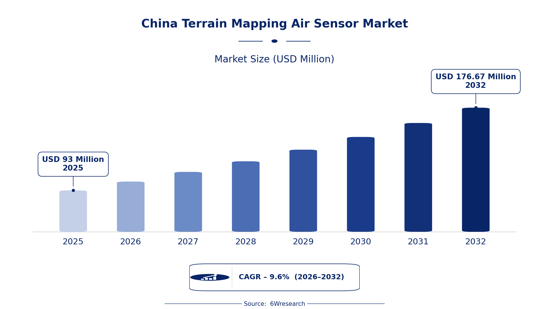
According to 6Wresearch internal database and industry insights, the China Terrain Mapping Air Sensor Market was valued at USD 93.0 million in 2025 and is projected to reach USD 176.67 million by 2032, growing at a CAGR of approximately 9.6% during 2026–2032.
China Terrain Mapping Air Sensor Market Highlights
| Report Metric | Details |
| Report Name | China Terrain Mapping Air Sensor Market |
| Market Size 2025 | USD 93.0 million |
| Market Size 2032 | USD 176.67 million |
| Absolute Growth 2025–2032 | USD 83.67 million |
| CAGR 2026–2032 | 9.6% |
| Peak Annual Growth | 11.0% in 2030 |
| Forecast Period | 2026–2032 |
| Historical Data | 2022–2025 |
| Base Year | 2025 |
| Leading Terrain Mapping Air Sensor, 2025 | LIDAR Mapping Systems (40% share) |
| Leading Product Type, 2025 | Airborne LIDAR (45% share) |
| Leading Sensor Tech, 2025 | LiDAR (43% share) |
| Leading Distribution Channel, 2025 | Geospatial Suppliers (42% share) |
| Leading End User Industry, 2025 | Mapping Agencies (45% share) |
| Fastest-Growing Terrain Mapping Air Sensor | 3D Imaging Sensors (11.9% CAGR) |
| Fastest-Growing Product Type | Optical Mapping (11.4% CAGR) |
| Fastest-Growing Sensor Tech | Photogrammetry (11.1% CAGR) |
| Fastest-Growing Distribution Channel | OEM Aerial Platforms (11.3% CAGR) |
| Fastest-Growing End User Industry | Survey & GIS (11.1% CAGR) |
| Growing Sector | Urban Planning |
| Key End Users | Mapping Agencies, Survey & GIS, Environmental Monitoring, Urban Planners |
China Terrain Mapping Air Sensor Market Year-wise Growth Rate and Key Drivers (2022–2032)
This graph illustrates the annual growth rates of the market from 2022 to 2032, highlighting a steady upward trajectory and projected market expansion over the forecast period.
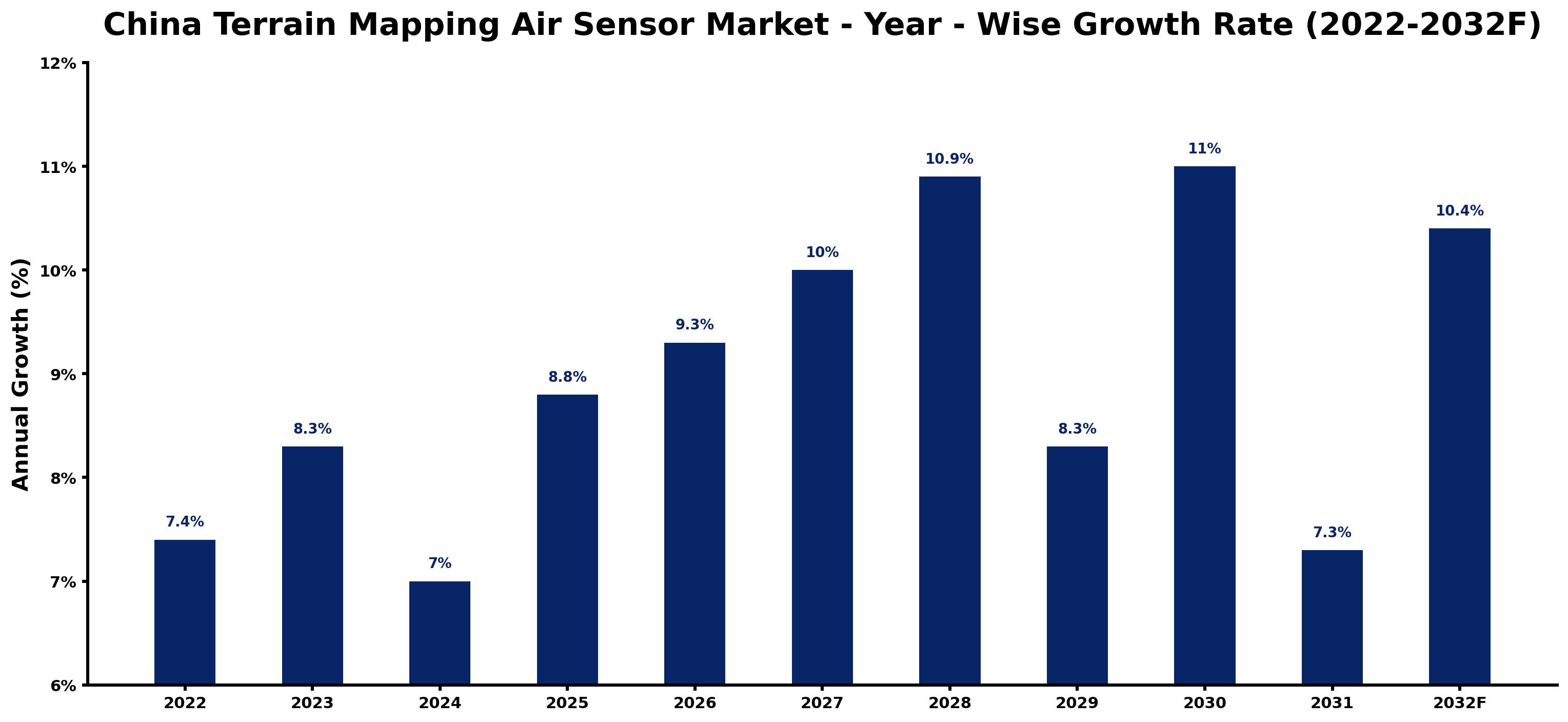
Year by year, the estimates below pair each growth rate with the development that shaped it.
| Year | Estimated Annual Growth (%) | Market Rationale |
| 2022 | 7.4 | The market experienced steady growth due to ongoing urban planning projects, particularly the National Land Surveying and Mapping Plan 2022-2025. |
| 2023 | 8.3 | Demand increased as the National Land Surveying and Mapping Plan 2022-2025 was implemented, driving technology adoption. |
| 2024 | 7.0 | Growth slowed as the market adjusted to the high demand levels from previous years. |
| 2025 | 8.8 | Infrastructure investment surged, with over 500 billion CNY allocated for urban planning, leading to faster growth. |
| 2026 | 9.3 | Urban planning initiatives are projected to sustain demand for advanced mapping technologies and solutions. |
| 2027 | 10.0 | The market is expected to expand as advanced mapping technologies gain traction among various buyer groups. |
| 2028 | 10.9 | Demand is anticipated to rise due to increased urban development projects across major cities. |
| 2029 | 8.3 | Growth is expected to slow as the market stabilises after a period of rapid expansion and investment. |
| 2030 | 11.0 | The peak growth rate is projected to be achieved, driven by the Smart City Development Strategy. |
| 2031 | 7.3 | Growth is expected to slow as the market begins to normalise after peak demand levels. |
| 2032 | 10.4 | The market is projected to grow steadily as urban planning investments continue to increase. |
Note: Market size estimations and growth projections presented in this report are based on 6Wresearch's proprietary forecasting methodology, utilizing the latest available industry data, government publications, and primary research inputs.
China Terrain Mapping Air Sensor Market Synopsis
The China Terrain Mapping Air Sensor Market encompasses advanced technologies for capturing detailed geographical data through LIDAR. These sensors are essential for applications such as topographic mapping and urban planning. The market is expanding due to substantial investments in infrastructure, with over 500 billion CNY allocated by 2025. Government initiatives, including the National Land Surveying and Mapping Plan 2022-2025, further support this growth by improving mapping capabilities nationwide. Key buyers include mapping agencies and urban planners, who are increasingly adopting these technologies to enhance efficiency and accuracy in their projects.
Market Dynamics Impact Analysis (2026–2032)
| Factor | Type | Impact | Primary Segment Affected |
| Increasing urbanisation and infrastructure development drive demand for accurate mapping solutions. | Driver | High | LIDAR Mapping Systems |
| Government-funded projects are expanding the use of terrain mapping technologies. | Driver | High | LIDAR Mapping Systems |
| The integration of advanced LIDAR technology in urban planning creates new market opportunities. | Opportunity | High | Airborne LIDAR |
| Growing demand for 3D imaging sensors in environmental monitoring presents investment opportunities. | Opportunity | Medium | 3D Imaging Sensors |
| High costs associated with advanced mapping technologies can limit accessibility for smaller firms. | Restraint | Medium | LIDAR Mapping Systems |
| Regulatory compliance requirements can delay project timelines for mapping agencies. | Restraint | High | Mapping Agencies |
| Terrain Mapping Air Sensor Market in China faces challenges related to technology integration. | Challenge | High | LIDAR Mapping Systems |
| Limited skilled workforce in advanced mapping technologies hampers market growth. | Challenge | Medium | LIDAR Mapping Systems |
Evaluation of Drivers in China Terrain Mapping Air Sensor Market (2026–2032)
Below mentioned are some major drivers and their influence on market dynamics.
| Drivers | Primary Segment Affected | Why It Matters (Evidence) |
| Urban planning initiatives are increasing the demand for precise mapping solutions. | Airborne LIDAR | In major cities like Beijing, LIDAR technology is widely adopted for urban planning projects, improving data accuracy. |
| Government projects are funding the integration of advanced mapping technologies. | LIDAR Mapping Systems | The National Geographic Information Public Service Platform supports mapping capabilities nationwide, driving demand for advanced technologies. |
| The rising population necessitates efficient mapping solutions for land use planning. | 3D Imaging Sensors | China's population of approximately 1.4 billion drives demand for accurate mapping solutions for urban development. |
| Investment in infrastructure development is creating opportunities for mapping technologies. | Survey & GIS | China's urban planning sector is expected to invest over 500 billion CNY by 2025, boosting demand for mapping technologies. |
| Environmental monitoring requirements are boosting the use of terrain mapping technologies. | LIDAR Mapping Systems | The Ministry of Ecology and Environment promotes terrain mapping for ecological assessments, increasing technology adoption. |
The National Land Surveying and Mapping Plan 2022-2025 will drive further adoption of advanced technologies. With a population of approximately 1.4 billion, the need for efficient mapping solutions is paramount. Investments in infrastructure, projected at over 500 billion CNY by 2025, will sustain market growth.
Evaluation of Restraints in China Terrain Mapping Air Sensor Market
The table below lists the restraints and the evidence behind each.
| Market Restraint | Primary Segment Affected | Why It Matters (Evidence) |
| High costs associated with advanced mapping technologies limit accessibility for smaller firms. | Mapping Agencies | The initial investment for LIDAR systems can be prohibitive for many smaller mapping agencies, hindering their operations. |
| Regulatory compliance can delay project timelines for mapping agencies. | Mapping Agencies | The updated Regulations on Surveying and Mapping require extensive documentation and approval, slowing down project initiation. |
| Limited availability of skilled professionals affects the implementation of advanced technologies. | Airborne LIDAR | The shortage of trained personnel in LIDAR technology can slow project execution and increase operational costs. |
| Integration of new technologies can be complex and time-consuming for existing systems. | 3D Imaging Sensors | Mapping agencies face challenges in adapting to rapidly evolving technology, leading to project delays. |
| Market fluctuations can impact funding for terrain mapping projects. | Survey & GIS | Economic uncertainties may lead to reduced budgets for mapping initiatives, affecting project scopes. |
China Terrain Mapping Air Sensor Market Challenges
The China Terrain Mapping Air Sensor market encounters several practical problems, starting with a skills shortage among professionals. This gap arises because training programs have not evolved alongside LIDAR technology advancements, leading to delays for producers who need qualified personnel. Next, outdated technology in various regions hampers effective data collection, as many local agencies have not updated their systems, causing inefficiencies for end users. High costs associated with advanced terrain mapping technologies also present a challenge, with some projects exceeding budgets by up to 30%, impacting buyers' investment capabilities. Finally, supply chain disruptions can delay essential component deliveries, forcing producers to extend project timelines and increasing costs for clients.
Trends in the China Terrain Mapping Air Sensor Market
Below mentioned are some of the trends shaping the China Terrain Mapping Air Sensor Market growth.
- Shift Towards Advanced LIDAR Technologies: The National Land Surveying and Mapping Plan 2022-2025 prioritises the adoption of advanced LIDAR technologies. This shift is set to enhance mapping accuracy and efficiency, with urban planning projects in cities like Shanghai at the forefront. Investment in LIDAR is expected to rise significantly by 2025.
- Emergence of 3D Imaging Sensors: Since 2022, there has been a notable increase in interest in 3D imaging sensors for environmental monitoring. Mapping agencies are increasingly employing these sensors to produce detailed three-dimensional representations of terrain. The demand for 3D imaging sensors is projected to grow at a CAGR of 11.1% through 2032.
- Increased Focus on Environmental Monitoring: In 2023, the Ministry of Ecology and Environment introduced guidelines that promote terrain mapping for ecological assessments. This emphasis is driving demand for advanced mapping technologies, with a projected rise in usage among environmental monitoring agencies.
- Adoption of Smart City Initiatives: The Smart City Development Strategy launched in 2023 is advocating for advanced mapping technologies in urban planning. This initiative is anticipated to result in a marked increase in demand for terrain mapping solutions across major urban centres.
Investment Opportunities in the China Terrain Mapping Air Sensor Market
Some of the investment opportunities in the China Terrain Mapping Air Sensor Market are mentioned below.
- Investment in Urban Planning Projects: Urban planning agencies are actively seeking advanced mapping solutions, with over 500 billion CNY allocated for infrastructure by 2025. This presents an opportunity for suppliers of terrain mapping technologies to partner with local governments to enhance project outcomes.
- Expansion of Environmental Monitoring Programs: Environmental agencies are increasingly investing in terrain mapping for ecological assessments, creating a demand for advanced sensors. Collaborating with these agencies can provide opportunities for technology providers to enter the market and expand their reach.
- Partnerships with Geospatial Suppliers: Geospatial suppliers are looking for innovative terrain mapping solutions to enhance their offerings. Establishing joint ventures with these suppliers can facilitate market entry and growth in China, benefiting both parties involved.
- Focus on Smart City Developments: With the Smart City Development Strategy in place, there is a growing need for advanced mapping technologies. Suppliers can capitalise on this trend by aligning their products with the strategic goals of urban planners, ensuring relevance in future projects.
Government Initiatives in the China Terrain Mapping Air Sensor Market
The Ministry of Natural Resources launched the 'National Geographic Information Development Plan (2021-2025)', which aims to improve the capabilities of terrain mapping technologies across China. This plan integrates advanced technologies to enhance data accuracy and establishes a comprehensive framework for geographic information management, benefiting producers and buyers alike. The initiative is set to allocate significant funding to support various mapping projects nationwide, ensuring efficient land use and environmental monitoring practices.
The National Administration of Surveying, Mapping and Geoinformation oversees the implementation of various mapping initiatives. This agency provides funding for projects under the New Infrastructure Initiative, targeting 200 billion CNY by 2025. Additionally, it approves new technologies for surveying and mapping, ensuring compliance with updated regulations. This support enables producers to adopt modern technologies and improves the capabilities of terrain mapping for buyers.
Future Insight of the China Terrain Mapping Air Sensor Market
Several forward-looking factors are likely to support the China Terrain Mapping Air Sensor market in the coming years. The National Land Surveying and Mapping Plan 2022-2025 will stimulate infrastructure investments, driving demand for advanced mapping solutions. Urban planning initiatives will increasingly embrace advanced technologies to improve efficiency and accuracy. By 2025, urban planning investments are expected to exceed 500 billion CNY, creating new opportunities for suppliers. The Smart City Development Strategy will further integrate terrain mapping into urban development projects, encouraging collaboration among stakeholders.
Market Segmentation Analysis
The report offers a comprehensive study of the following market segments and their leading categories in the market.
By Terrain Mapping Air Sensor – LIDAR Mapping Systems Dominated, 3D Imaging Sensors Expected to Grow Fastest
According to Vasudha, AM at 6Wresearch, with a 40% revenue share in 2025, LIDAR Mapping Systems was the largest terrain mapping air sensor category. LIDAR Mapping Systems lead the market due to their extensive application in topographical data collection, particularly in urban centres like Beijing and Shanghai. Their integration into governmental infrastructure projects ensures a strong installed base and consistent demand. 3D Imaging Sensors are projected to grow fastest, at a CAGR of 11.9% during 2026–2032. 3D Imaging Sensors are experiencing rapid growth as they are essential for creating detailed three-dimensional terrain representations, increasingly necessary for urban planning. As urban areas expand, the demand for accurate 3D mapping will continue to rise, propelling this segment forward. Suppliers should prioritise the development of 3D Imaging Sensors to meet the growing needs of urban planners.
By Product Type – Airborne LIDAR Dominated, Optical Mapping Expected to Grow Fastest
Airborne LIDAR took a 45% share of product type in 2025, more than any other category. Airborne LIDAR holds the largest market share due to its role as the primary method for large-scale terrain mapping, extensively used by governmental and private entities. Its effectiveness in providing precise geographical data makes it essential for infrastructure projects across China. Over 2026–2032, Optical Mapping is expected to post the fastest growth, at a CAGR of 11.4%. Optical Mapping is experiencing rapid growth as it complements Airborne LIDAR by enhancing visual data, which is vital for comprehensive mapping solutions. The rising demand for integrated mapping technologies will further solidify Optical Mapping's importance in the market. Suppliers should focus on developing integrated solutions that combine Airborne LIDAR with Optical Mapping to deliver superior mapping results.
By Sensor Tech – LiDAR Dominated, Photogrammetry Expected to Grow Fastest
LiDAR held a 43% share of the China Terrain Mapping Air Sensor Market by sensor tech in 2025. LiDAR technology commands the largest market share as it is the core technology for terrain mapping sensors, providing exceptional accuracy and efficiency in data collection. Its widespread application in urban planning and environmental assessments underpins its dominant position in the market. Photogrammetry is set to record the highest CAGR in this split, 11.1% over 2026–2032. Photogrammetry is witnessing significant growth as it offers crucial data validation and supplementary mapping techniques, especially in complex projects. This segment's expansion is expected to continue as users increasingly seek to enhance mapping accuracy. Suppliers must consider integrating Photogrammetry capabilities into their offerings to address the growing demand for improved mapping precision.
By Distribution Channel – Geospatial Suppliers Dominated, OEM Aerial Platforms Expected to Grow Fastest
Geospatial Suppliers accounted for a 42% market share by distribution channel in 2025. Geospatial Suppliers hold the largest market share as they are vital in providing essential equipment and support for terrain mapping technologies. Their established connections with government and private entities ensure a steady demand for their offerings. The quickest growth will come from OEM Aerial Platforms, forecast to expand at a CAGR of 11.3% between 2026 and 2032. OEM Aerial Platforms are rapidly expanding as they manufacture drones and aircraft tailored for airborne mapping, addressing the rising need for efficient data collection methods. This growth reflects the trend towards integrating advanced technologies in mapping. Suppliers should consider partnerships with OEM Aerial Platforms to capitalise on the growing market for drone-based mapping solutions.
By End User Industry – Mapping Agencies Dominated, Survey & GIS Expected to Grow Fastest
The largest end user industry category in 2025 was Mapping Agencies, with a 45% share of total revenue. Mapping Agencies represent the largest share of the market, encompassing both government and private entities that heavily rely on mapping data for various initiatives. Their continuous need for accurate geographical information ensures stable demand for terrain mapping technologies. Survey & GIS is projected to grow fastest, at a CAGR of 11.1% during 2026–2032. The Survey & GIS sector is rapidly growing as it includes key users of terrain mapping data for a range of applications, driven by substantial investments in infrastructure and urban development. This trend reflects a broader acceptance of GIS technologies across various industries. Buyers in the Survey & GIS sector should prioritise the acquisition of advanced mapping technologies to enhance their project outcomes.
Key Attractiveness of the Report
- 10 Years of Market Numbers
- Historical Data Starting from 2022 to 2025
- Base Year 2025
- Forecast Data until 2032
- Key Performance Indicators Impacting the Market
- Major Upcoming Developments and Projects
Key Highlights of the Report:
- China Terrain Mapping Air Sensor Market Outlook
- Market Size of China Terrain Mapping Air Sensor Market, 2025
- Forecast of China Terrain Mapping Air Sensor Market, 2032
- Historical Data and Forecast of China Terrain Mapping Air Sensor Revenues & Volume for the Period 2022 - 2032F
- China Terrain Mapping Air Sensor Market Trend Evolution
- China Terrain Mapping Air Sensor Market Drivers and Challenges
- China Terrain Mapping Air Sensor Price Trends
- China Terrain Mapping Air Sensor Porter's Five Forces
- China Terrain Mapping Air Sensor Industry Life Cycle
- Historical Data and Forecast of China Terrain Mapping Air Sensor Market Revenues & Volume By Terrain Mapping Air Sensor for the Period 2022 - 2032F
- Historical Data and Forecast of China Terrain Mapping Air Sensor Market Revenues & Volume By LIDAR Mapping Systems for the Period 2022 - 2032F
- Historical Data and Forecast of China Terrain Mapping Air Sensor Market Revenues & Volume By 3D Imaging Sensors for the Period 2022 - 2032F
- Historical Data and Forecast of China Terrain Mapping Air Sensor Market Revenues & Volume By Hyperspectral Sensors for the Period 2022 - 2032F
- Historical Data and Forecast of China Terrain Mapping Air Sensor Market Revenues & Volume By Inertial-LIDAR Integrators for the Period 2022 - 2032F
- Historical Data and Forecast of China Terrain Mapping Air Sensor Market Revenues & Volume By Product Type for the Period 2022 - 2032F
- Historical Data and Forecast of China Terrain Mapping Air Sensor Market Revenues & Volume By Airborne LIDAR for the Period 2022 - 2032F
- Historical Data and Forecast of China Terrain Mapping Air Sensor Market Revenues & Volume By Optical Mapping for the Period 2022 - 2032F
- Historical Data and Forecast of China Terrain Mapping Air Sensor Market Revenues & Volume By Multi-spectral Imaging for the Period 2022 - 2032F
- Historical Data and Forecast of China Terrain Mapping Air Sensor Market Revenues & Volume By LiDAR + IMU Units for the Period 2022 - 2032F
- Historical Data and Forecast of China Terrain Mapping Air Sensor Market Revenues & Volume By Sensor Tech for the Period 2022 - 2032F
- Historical Data and Forecast of China Terrain Mapping Air Sensor Market Revenues & Volume By LiDAR for the Period 2022 - 2032F
- Historical Data and Forecast of China Terrain Mapping Air Sensor Market Revenues & Volume By Photogrammetry for the Period 2022 - 2032F
- Historical Data and Forecast of China Terrain Mapping Air Sensor Market Revenues & Volume By VNIR/SWIR for the Period 2022 - 2032F
- Historical Data and Forecast of China Terrain Mapping Air Sensor Market Revenues & Volume By GPS/IMU Fusion for the Period 2022 - 2032F
- Historical Data and Forecast of China Terrain Mapping Air Sensor Market Revenues & Volume By Distribution Channel for the Period 2022 - 2032F
- Historical Data and Forecast of China Terrain Mapping Air Sensor Market Revenues & Volume By Geospatial Suppliers for the Period 2022 - 2032F
- Historical Data and Forecast of China Terrain Mapping Air Sensor Market Revenues & Volume By OEM Aerial Platforms for the Period 2022 - 2032F
- Historical Data and Forecast of China Terrain Mapping Air Sensor Market Revenues & Volume By Online Defense Stores for the Period 2022 - 2032F
- Historical Data and Forecast of China Terrain Mapping Air Sensor Market Revenues & Volume By Aviation Integrators for the Period 2022 - 2032F
- Historical Data and Forecast of China Terrain Mapping Air Sensor Market Revenues & Volume By End User Industry for the Period 2022 - 2032F
- Historical Data and Forecast of China Terrain Mapping Air Sensor Market Revenues & Volume By Mapping Agencies for the Period 2022 - 2032F
- Historical Data and Forecast of China Terrain Mapping Air Sensor Market Revenues & Volume By Survey & GIS for the Period 2022 - 2032F
- Historical Data and Forecast of China Terrain Mapping Air Sensor Market Revenues & Volume By Environmental Monitoring for the Period 2022 - 2032F
- Historical Data and Forecast of China Terrain Mapping Air Sensor Market Revenues & Volume By Urban Planning for the Period 2022 - 2032F
- China Terrain Mapping Air Sensor Import Export Trade Statistics
- Market Opportunity Assessment By Terrain Mapping Air Sensor
- Market Opportunity Assessment By Product Type
- Market Opportunity Assessment By Sensor Tech
- Market Opportunity Assessment By Distribution Channel
- Market Opportunity Assessment By End User Industry
- China Terrain Mapping Air Sensor Top Companies Market Share
- China Terrain Mapping Air Sensor Competitive Benchmarking By Technical and Operational Parameters
- China Terrain Mapping Air Sensor Company Profiles
- China Terrain Mapping Air Sensor Key Strategic Recommendations
Market Covered
This report examines the market across the segments below.
By Terrain Mapping Air Sensor
- LIDAR Mapping Systems
- 3D Imaging Sensors
- Hyperspectral Sensors
- Inertial-LIDAR Integrators
By Product Type
- Airborne LIDAR
- Optical Mapping
- Multi-spectral Imaging
- LiDAR + IMU Units
By Sensor Tech
- LiDAR
- Photogrammetry
- VNIR/SWIR
- GPS/IMU Fusion
By Distribution Channel
- Geospatial Suppliers
- OEM Aerial Platforms
- Online Defense Stores
- Aviation Integrators
By End User Industry
- Mapping Agencies
- Survey & GIS
- Environmental Monitoring
- Urban Planning































