China Terrain Mapping Radar Market Size & Growth Rate
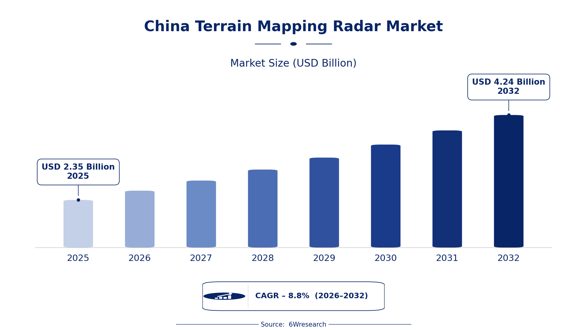
According to 6Wresearch internal database and industry insights, the China Terrain Mapping Radar Market was valued at USD 2.35 billion in 2025 and is projected to reach USD 4.24 billion by 2032, growing at a CAGR of approximately 8.8% during 2026–2032.
China Terrain Mapping Radar Market Highlights
| Report Metric | Details |
| Report Name | China Terrain Mapping Radar Market |
| Market Size 2025 | USD 2.35 billion |
| Market Size 2032 | USD 4.24 billion |
| Absolute Growth 2025–2032 | USD 1.89 billion |
| CAGR 2026–2032 | 8.8% |
| Peak Annual Growth | 11.6% in 2032 |
| Forecast Period | 2026–2032 |
| Historical Data | 2022–2025 |
| Base Year | 2025 |
| Leading Terrain Mapping Radar, 2025 | Airborne SAR Systems (44% share) |
| Leading Product Type, 2025 | Synthetic Aperture (39% share) |
| Leading Radar Type, 2025 | X/Ku‑Band (37% share) |
| Leading Distribution Channel, 2025 | Defense OEMs (47% share) |
| Leading End User Industry, 2025 | Remote Sensing (35% share) |
| Fastest-Growing Terrain Mapping Radar | UAV Mapping Radar (10.8% CAGR) |
| Fastest-Growing Product Type | Mobile Mapping Units (9.9% CAGR) |
| Fastest-Growing Distribution Channel | Drone Integrators (11.1% CAGR) |
| Fastest-Growing End User Industry | Agriculture Monitoring (11.3% CAGR) |
| Growing Sector | Agriculture Monitoring |
| Key End Users | Remote Sensing, Agriculture Monitoring, Geological Surveying, Climate Research |
China Terrain Mapping Radar Market Year-wise Growth Rate and Key Drivers (2022–2032)
This graph illustrates the annual growth rates of the market from 2022 to 2032, highlighting a steady upward trajectory and projected market expansion over the forecast period.
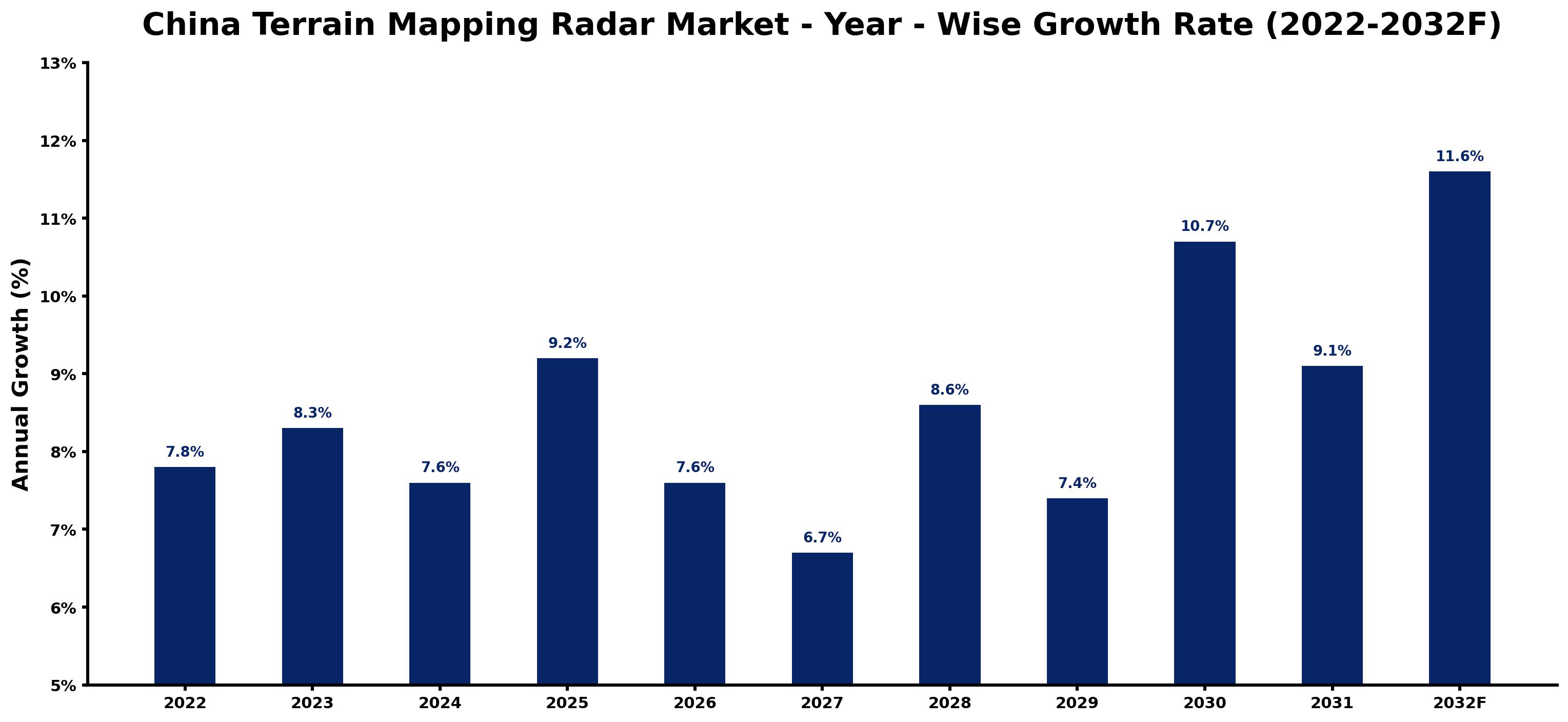
The table below sets out the estimated growth rate for each year and the main factor behind it.
| Year | Estimated Annual Growth (%) | Market Rationale |
| 2022 | 7.8 | The market showed a steady demand from government projects and research institutions. |
| 2023 | 8.3 | Growth accelerated due to increased investments in remote sensing technologies. |
| 2024 | 7.6 | Demand slowed slightly as projects reached completion, yet continued to grow. |
| 2025 | 9.2 | A surge in urban planning initiatives drove faster growth this year. |
| 2026 | 7.6 | Growth is expected to slow as the Geological Survey Modernization Strategy promotes the adoption of ground-based mapping radar. |
| 2027 | 6.7 | Demand is projected to decrease slightly as investments in environmental monitoring stabilise. |
| 2028 | 8.6 | An increase in environmental monitoring initiatives is expected to boost growth again. |
| 2029 | 7.4 | Demand is projected to slow as the market begins to stabilise after rapid expansion. |
| 2030 | 10.7 | Growth is expected to pick up due to new satellite mapping missions being launched. |
| 2031 | 9.1 | A slight slowdown is projected as the market adjusts to new technologies. |
| 2032 | 11.6 | Demand is expected to surge again with the completion of major government initiatives. |
Note: Market size estimations and growth projections presented in this report are based on 6Wresearch's proprietary forecasting methodology, utilizing the latest available industry data, government publications, and primary research inputs.
China Terrain Mapping Radar Market Synopsis
Terrain Mapping Radar encompasses sophisticated radar systems utilised for mapping and surveying terrains across China. This technology incorporates synthetic aperture radar techniques, playing a crucial role in applications such as remote sensing and geological surveying. The China Terrain Mapping Radar Market is experiencing growth, driven by increasing demand from government agencies and research institutions, particularly in precision agriculture and environmental monitoring. Substantial government investment in remote sensing technologies and initiatives like the Precision Agriculture Initiative are creating new opportunities.
Market Dynamics Impact Analysis (2026–2032)
| Factor | Type | Impact | Primary Segment Affected |
| Increased government investment in remote sensing projects | Driver | High | Remote Sensing |
| Growing demand for precision agriculture monitoring | Driver | High | UAV Mapping Radar |
| Expansion of urban planning initiatives | Opportunity | Medium | Airborne SAR Systems |
| Rising need for geological surveying in mining | Opportunity | Medium | Ground-Based Mapping Radar |
| High costs associated with advanced radar technology | Restraint | High | Synthetic Aperture |
| Limited availability of skilled professionals in radar technology | Restraint | Medium | Mobile Mapping Units |
| Delays in government approvals for new projects | Challenge | High | Satellite Mapping Radar |
| Supply chain disruptions affecting radar components | Challenge | Medium | Airborne SAR Systems |
Evaluation of Drivers in China Terrain Mapping Radar Market (2026–2032)
The factors lifting demand, and the evidence behind each, are summarised below.
| Drivers | Primary Segment Affected | Why It Matters (Evidence) |
| Government investment in remote sensing technologies | Remote Sensing | This investment drives demand for terrain mapping radar systems, with a budget of 500 million yuan for 2023. |
| Increased agricultural monitoring needs | UAV Mapping Radar | The Ministry of Agriculture's Precision Agriculture Initiative promotes UAV mapping radar for crop monitoring in over 20 provinces by 2025. |
| Urban planning initiatives in major cities | Airborne SAR Systems | Urban planning projects in cities like Shanghai are increasing the demand for high-resolution mapping technologies. |
| Mining sector growth in Inner Mongolia | Ground-Based Mapping Radar | The mining sector's expansion is leading to higher demand for detailed ground surveys, particularly in Inner Mongolia. |
| Rising environmental monitoring requirements | Mobile Mapping Units | The need for environmental assessments is driving the adoption of mobile mapping units, especially in coastal regions. |
The Terrain Mapping Radar market in China is growing on the back of heightened end-use demand from sectors such as remote sensing and agriculture. Investment in remote sensing technologies is boosting demand, with a budget of 500 million yuan for 2023. The mining sector's expansion in Inner Mongolia is also raising the demand for ground-based mapping radar systems.
Evaluation of Restraints in China Terrain Mapping Radar Market
The main factors holding the market back are set out below.
| Market Restraint | Primary Segment Affected | Why It Matters (Evidence) |
| High costs associated with advanced radar technology | Synthetic Aperture | The production costs of synthetic aperture radar systems limit accessibility for smaller firms. |
| Limited availability of skilled professionals in radar technology | Mobile Mapping Units | A shortage of qualified personnel affects the deployment and maintenance of mobile mapping units. |
| Delays in government approvals for new projects | Satellite Mapping Radar | Regulatory delays hinder timely project execution, impacting market growth. |
| Supply chain disruptions affecting radar components | Airborne SAR Systems | Supply chain challenges have led to delays in component availability, affecting production schedules. |
| Market competition from alternative technologies | UAV Mapping Radar | Emerging technologies may divert investment away from traditional terrain mapping radar, limiting market share. |
China Terrain Mapping Radar Market Challenges
Buyers in the China Terrain Mapping Radar market face escalating costs due to complex regulatory approvals, which can delay project timelines by up to six months. Government agencies, in particular, experience inflated budgets by 15% as they navigate these compliance requirements. The rapid evolution of radar technology necessitates continuous investment, which strains smaller producers who may lack the resources to keep pace. Furthermore, reliance on outdated radar systems in sectors like agriculture results in inefficient data acquisition, extending project durations and increasing operational costs for buyers in environmental monitoring.
Trends in the China Terrain Mapping Radar Market
Buyers and suppliers in the China Terrain Mapping Radar Market are adjusting to the following trends.
- Shift towards Precision Agriculture Monitoring: Since 2022, there has been a heightened focus on precision agriculture, with the Ministry of Agriculture advocating for UAV mapping radar technologies. This shift aims to enhance crop monitoring across over 20 provinces by 2025.
- Transition to Lightweight SAR Systems: The uptake of lightweight SAR systems is increasing, especially in environmental monitoring. The National Development and Reform Commission's strategy seeks to promote these systems by 2025, enhancing operational efficiency for buyers.
- Emergence of Mobile Mapping Units: Mobile mapping units are gaining popularity for on-site data collection. In 2023, the Ministry of Natural Resources announced a new initiative to incorporate these units into land surveying practices, improving data accuracy.
- Growing Use of Satellite Mapping Radar: The China National Space Administration is advancing satellite mapping technologies, with new missions planned by 2025. This initiative is set to greatly enhance earth observation capabilities.
Investment Opportunities in the China Terrain Mapping Radar Market
Investors looking at the China Terrain Mapping Radar Market should consider the following areas.
- Remote Sensing Initiatives in Major Cities: Urban centres are making substantial investments in remote sensing technologies, with a budget of 600 million yuan for 2023. Collaborating with government agencies presents opportunities for suppliers to address this demand.
- Agricultural Sector Expansion: The anticipated adoption of UAV mapping radar technologies in over 20 provinces by 2025 within the agricultural sector offers a significant opportunity. Engaging with local agricultural cooperatives can facilitate market entry.
- Geological Survey Modernization Strategy: The Ministry of Natural Resources' Geological Survey Modernization Strategy promotes the use of ground-based mapping radar. Suppliers can enter this market by partnering with geological survey agencies to enhance their capabilities.
- Investment in Environmental Monitoring: The National Development and Reform Commission's strategy to promote lightweight SAR systems by 2025 indicates a growing opportunity. Suppliers should explore partnerships with environmental agencies to align with this trend.
Government Initiatives in the China Terrain Mapping Radar Market
In 2023, the Ministry of Agriculture initiated the 'Precision Agriculture Initiative' aimed at enhancing crop monitoring through UAV mapping radar, with a budget of 300 million yuan. This initiative builds upon the existing framework established by the National Remote Sensing Development Plan, which seeks to increase the utilisation of terrain mapping technologies by 40% by 2025, thereby improving the sector's overall capabilities. These measures assist producers in meeting the rising demand for advanced mapping technologies.
The China National Space Administration is responsible for implementing the 'Spaceborne Radar Program', which allocates funding for various satellite mapping projects. Additionally, the Ministry of Ecology and Environment's 'Climate Change Monitoring Program' focuses on employing terrain mapping radar for climate research, ensuring that producers can meet the growing demand for high-quality terrain mapping radar systems. The budget for these initiatives is projected to exceed 600 million yuan, facilitating significant advancements in technology and production capabilities.
Future Insight of the China Terrain Mapping Radar Market
The China Terrain Mapping Radar market is set to evolve by 2032, propelled by advancements in satellite mapping technologies and substantial government investment in remote sensing. The Ministry of Agriculture's initiative to deploy UAV mapping technologies in over 20 provinces will bolster agricultural monitoring capabilities. The integration of new radar systems into land surveying practices will enhance efficiency for buyers. With the China National Space Administration planning new spaceborne SAR missions, the emphasis on improving mapping capabilities will further drive market development.
Market Segmentation Analysis
The report offers a comprehensive study of the following market segments and their leading categories in the market.
By Terrain Mapping Radar – Airborne SAR Systems Dominated, UAV Mapping Radar Expected to Grow Fastest
According to Vasudha, AM at 6Wresearch, in 2025, Airborne SAR Systems led the terrain mapping radar split with a 44% share. Airborne SAR Systems dominate the China Terrain Mapping Radar Market due to their crucial role in aerial mapping and surveillance, particularly in government-led projects. Their extensive application in initiatives overseen by the National Remote Sensing Center of China solidifies their leading market share. The quickest growth will come from UAV Mapping Radar, forecast to expand at a CAGR of 10.8% between 2026 and 2032. UAV Mapping Radar is experiencing rapid growth as it becomes increasingly integrated into drones for precise terrain mapping, driven by the Ministry of Agriculture's programme for precision agriculture monitoring. The anticipated adoption across over 20 provinces by 2025 highlights its rising importance in the market. Suppliers should focus on enhancing UAV Mapping Radar technology to meet the growing demand from the agricultural sector.
By Product Type – Synthetic Aperture Dominated, Mobile Mapping Units Expected to Grow Fastest
Synthetic Aperture held a 39% share of the China Terrain Mapping Radar Market by product type in 2025. Synthetic Aperture technology holds the largest market share due to its essential role in delivering high-resolution imaging, which is critical for various terrain mapping applications. Its widespread use in government and research initiatives underscores its significance in the market. Over 2026–2032, Mobile Mapping Units are expected to post the fastest growth, at a CAGR of 9.9%. Mobile Mapping Units are set to grow rapidly, driven by their effectiveness in on-site data collection, particularly for urban planning and infrastructure projects. Government initiatives aimed at improving mapping capabilities further support this growth. Buyers should consider investing in Mobile Mapping Units to enhance their data collection processes and maintain a competitive edge.
By Radar Type – X/Ku‑Band Dominated and Is Expected to Record the Fastest Growth
X/Ku‑Band took a 37% share of radar type in 2025, more than any other category. X/Ku-Band radar systems lead the market as they are widely used for high-resolution applications, especially in urban planning and environmental monitoring. Their established presence in major cities across China reinforces their significant market share. The same category is also set to grow fastest, at a CAGR of 9.9% during 2026–2032. X/Ku-Band radar systems are also the fastest-growing segment, propelled by the increasing demand for high-resolution imaging across multiple sectors. Their versatility ensures they remain at the forefront of radar technology advancements. Suppliers must prioritise continuous innovation within the X/Ku-Band segment to maintain their competitive advantage in the market.
By Distribution Channel – Defense OEMs Dominated, Drone Integrators Expected to Grow Fastest
The largest distribution channel category in 2025 was Defense OEMs, with a 47% share of total revenue. Defense OEMs capture the largest market share as they supply radar systems specifically for military applications, which require high reliability and performance. Their established relationships with government agencies ensure consistent demand. Drone Integrators are projected to grow fastest, at a CAGR of 11.1% during 2026–2032. Drone Integrators are experiencing rapid growth as they integrate radar systems into UAVs, reflecting the increasing use of drones in various industries. This trend is likely to continue as drone technology advances. Suppliers should build partnerships with Drone Integrators to tap into the expanding UAV market.
By End User Industry – Remote Sensing Dominated, Agriculture Monitoring Expected to Grow Fastest
With a 35% revenue share in 2025, Remote Sensing was the largest end user industry category. Remote Sensing is the leading end-user industry, essential for environmental monitoring and government projects that require precise data. Its critical role in initiatives by the China Geological Survey underscores its importance in the market. The quickest growth will come from Agriculture Monitoring, forecast to expand at a CAGR of 11.3% between 2026 and 2032. Agriculture Monitoring is the fastest-growing segment, driven by the increasing need for crop assessment and management technologies. The Ministry of Agriculture's initiatives to adopt UAV mapping technologies further fuel this growth. Buyers in the agriculture sector should prioritise investments in advanced monitoring technologies to optimise crop management.
Key Attractiveness of the Report
- 10 Years of Market Numbers
- Historical Data Starting from 2022 to 2025
- Base Year 2025
- Forecast Data until 2032
- Key Performance Indicators Impacting the Market
- Major Upcoming Developments and Projects
Key Highlights of the Report:
- China Terrain Mapping Radar Market Outlook
- Market Size of China Terrain Mapping Radar Market, 2025
- Forecast of China Terrain Mapping Radar Market, 2032
- Historical Data and Forecast of China Terrain Mapping Radar Revenues & Volume for the Period 2022 - 2032F
- China Terrain Mapping Radar Market Trend Evolution
- China Terrain Mapping Radar Market Drivers and Challenges
- China Terrain Mapping Radar Price Trends
- China Terrain Mapping Radar Porter's Five Forces
- China Terrain Mapping Radar Industry Life Cycle
- Historical Data and Forecast of China Terrain Mapping Radar Market Revenues & Volume By Terrain Mapping Radar for the Period 2022 - 2032F
- Historical Data and Forecast of China Terrain Mapping Radar Market Revenues & Volume By Airborne SAR Systems for the Period 2022 - 2032F
- Historical Data and Forecast of China Terrain Mapping Radar Market Revenues & Volume By UAV Mapping Radar for the Period 2022 - 2032F
- Historical Data and Forecast of China Terrain Mapping Radar Market Revenues & Volume By Ground-Based Mapping Radar for the Period 2022 - 2032F
- Historical Data and Forecast of China Terrain Mapping Radar Market Revenues & Volume By Satellite Mapping Radar for the Period 2022 - 2032F
- Historical Data and Forecast of China Terrain Mapping Radar Market Revenues & Volume By Product Type for the Period 2022 - 2032F
- Historical Data and Forecast of China Terrain Mapping Radar Market Revenues & Volume By Synthetic Aperture for the Period 2022 - 2032F
- Historical Data and Forecast of China Terrain Mapping Radar Market Revenues & Volume By Lightweight SAR for the Period 2022 - 2032F
- Historical Data and Forecast of China Terrain Mapping Radar Market Revenues & Volume By Mobile Mapping Units for the Period 2022 - 2032F
- Historical Data and Forecast of China Terrain Mapping Radar Market Revenues & Volume By Spaceborne SAR for the Period 2022 - 2032F
- Historical Data and Forecast of China Terrain Mapping Radar Market Revenues & Volume By Radar Type for the Period 2022 - 2032F
- Historical Data and Forecast of China Terrain Mapping Radar Market Revenues & Volume By X/Ku Band for the Period 2022 - 2032F
- Historical Data and Forecast of China Terrain Mapping Radar Market Revenues & Volume By C Band for the Period 2022 - 2032F
- Historical Data and Forecast of China Terrain Mapping Radar Market Revenues & Volume By P Band for the Period 2022 - 2032F
- Historical Data and Forecast of China Terrain Mapping Radar Market Revenues & Volume By L Band for the Period 2022 - 2032F
- Historical Data and Forecast of China Terrain Mapping Radar Market Revenues & Volume By Distribution Channel for the Period 2022 - 2032F
- Historical Data and Forecast of China Terrain Mapping Radar Market Revenues & Volume By Defense OEMs for the Period 2022 - 2032F
- Historical Data and Forecast of China Terrain Mapping Radar Market Revenues & Volume By Drone Integrators for the Period 2022 - 2032F
- Historical Data and Forecast of China Terrain Mapping Radar Market Revenues & Volume By Geotech Suppliers for the Period 2022 - 2032F
- Historical Data and Forecast of China Terrain Mapping Radar Market Revenues & Volume By Space Agencies for the Period 2022 - 2032F
- Historical Data and Forecast of China Terrain Mapping Radar Market Revenues & Volume By End User Industry for the Period 2022 - 2032F
- Historical Data and Forecast of China Terrain Mapping Radar Market Revenues & Volume By Remote Sensing for the Period 2022 - 2032F
- Historical Data and Forecast of China Terrain Mapping Radar Market Revenues & Volume By Agriculture Monitoring for the Period 2022 - 2032F
- Historical Data and Forecast of China Terrain Mapping Radar Market Revenues & Volume By Geological Surveying for the Period 2022 - 2032F
- Historical Data and Forecast of China Terrain Mapping Radar Market Revenues & Volume By Climate Research for the Period 2022 - 2032F
- China Terrain Mapping Radar Import Export Trade Statistics
- Market Opportunity Assessment By Terrain Mapping Radar
- Market Opportunity Assessment By Product Type
- Market Opportunity Assessment By Radar Type
- Market Opportunity Assessment By Distribution Channel
- Market Opportunity Assessment By End User Industry
- China Terrain Mapping Radar Top Companies Market Share
- China Terrain Mapping Radar Competitive Benchmarking By Technical and Operational Parameters
- China Terrain Mapping Radar Company Profiles
- China Terrain Mapping Radar Key Strategic Recommendations
Market Covered
The report offers an extensive study of the following market segments.
By Terrain Mapping Radar
- Airborne SAR Systems
- UAV Mapping Radar
- Ground-Based Mapping Radar
- Satellite Mapping Radar
By Product Type
- Synthetic Aperture
- Lightweight SAR
- Mobile Mapping Units
- Spaceborne SAR
By Radar Type
- X/Ku‑Band
- C‑Band
- P‑Band
- L‑Band
By Distribution Channel
- Defense OEMs
- Drone Integrators
- Geotech Suppliers
- Space Agencies
By End User Industry
- Remote Sensing
- Agriculture Monitoring
- Geological Surveying
- Climate Research































