India Terrain Mapping Radar Market Size & Growth Rate
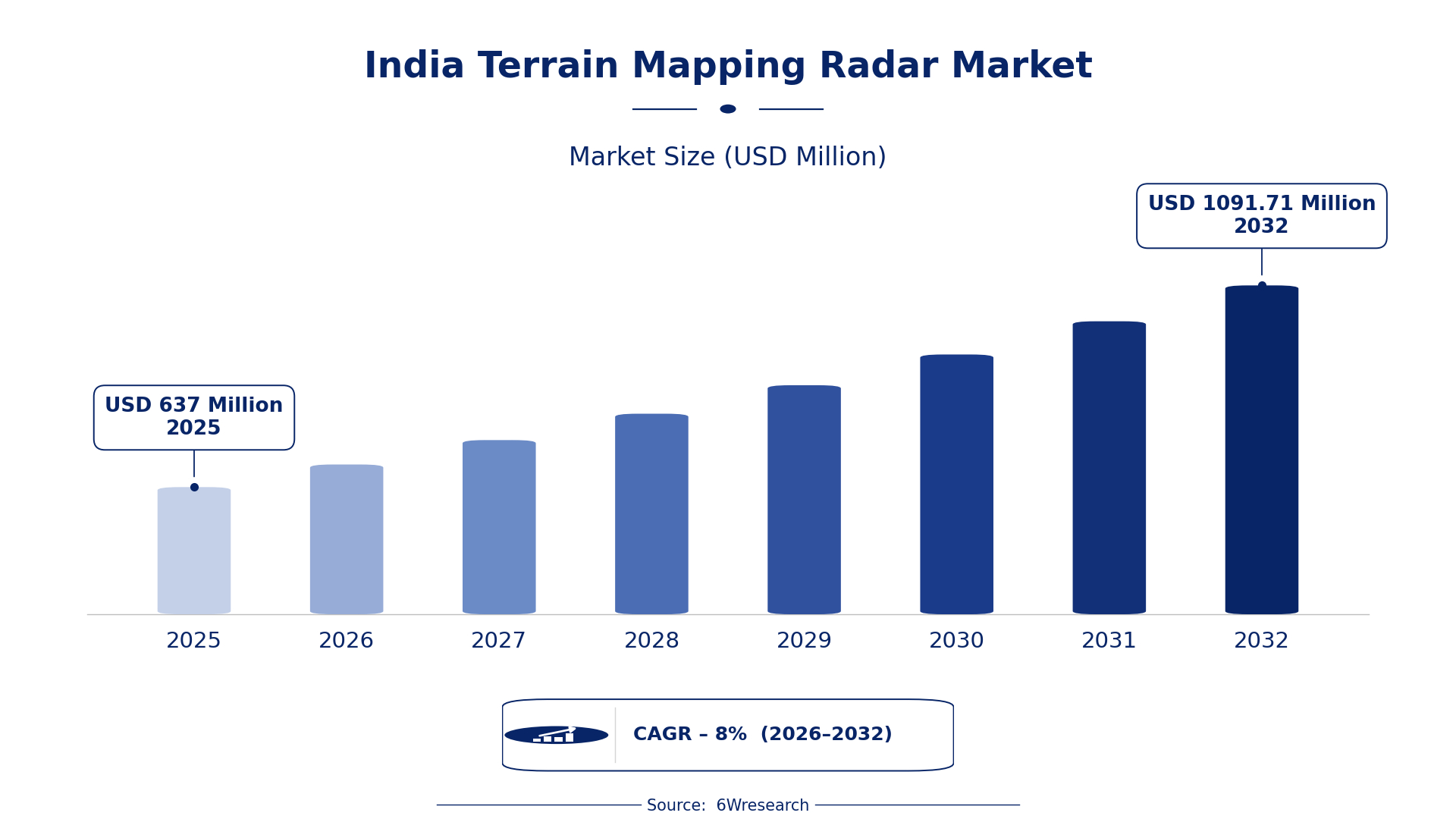
According to 6Wresearch internal database and industry insights, the India Terrain Mapping Radar Market was valued at USD 637.0 million in 2025 and is projected to reach USD 1,091.71 million by 2032, growing at a CAGR of approximately 8% during 2026–2032.
India Terrain Mapping Radar Market Highlights
| Report Metric | Details |
| Report Name | India Terrain Mapping Radar Market |
| Market Size 2025 | USD 637.0 million |
| Market Size 2032 | USD 1,091.71 million |
| Absolute Growth 2025–2032 | USD 454.71 million |
| CAGR 2026–2032 | 8% |
| Peak Annual Growth | 10.4% in 2027 |
| Forecast Period | 2026–2032 |
| Historical Data | 2022–2025 |
| Base Year | 2025 |
| Leading Terrain Mapping Radar, 2025 | Airborne SAR Systems (49% share) |
| Leading Product Type, 2025 | Synthetic Aperture (47% share) |
| Leading Radar Type, 2025 | X/Ku‑Band (47% share) |
| Leading Distribution Channel, 2025 | Defense OEMs (36% share) |
| Leading End User Industry, 2025 | Remote Sensing (45% share) |
| Fastest-Growing Terrain Mapping Radar | UAV Mapping Radar (10.1% CAGR) |
| Fastest-Growing Product Type | Mobile Mapping Units (9.8% CAGR) |
| Fastest-Growing Distribution Channel | Drone Integrators (9.5% CAGR) |
| Fastest-Growing End User Industry | Geological Surveying (10.2% CAGR) |
| Growing Sector | Agricultural Monitoring |
| Key End Users | Defense, Environmental Agencies, Agricultural Sector, Geological Surveying |
India Terrain Mapping Radar Market Year-wise Growth Rate and Key Drivers (2022–2032)
This graph illustrates the annual growth rates of the market from 2022 to 2032, highlighting a steady upward trajectory and projected market expansion over the forecast period.
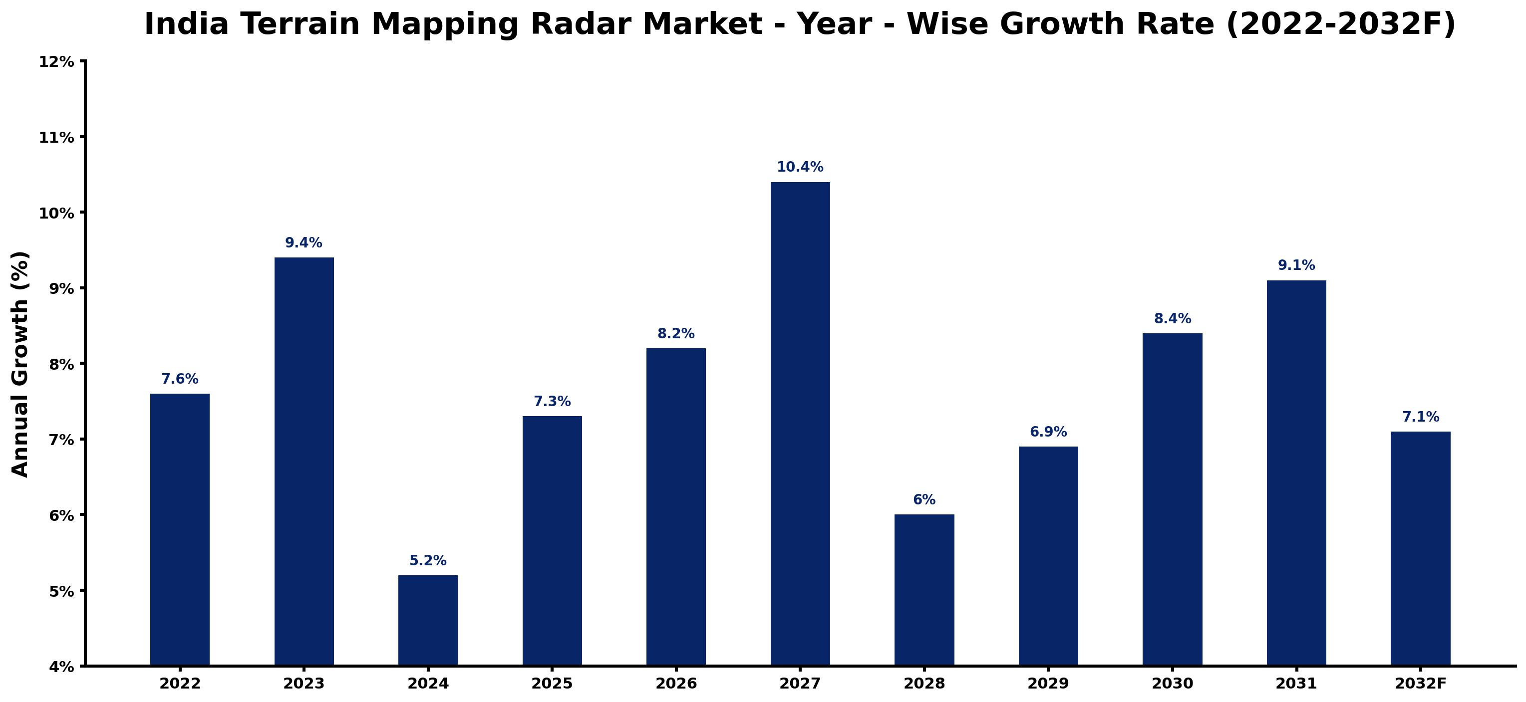
The following table presents the estimated annual growth rate for each year together with the principal factor influencing market performance.
| Year | Estimated Annual Growth (%) | Market Rationale |
| 2022 | 7.6 | The market showed solid demand due to ongoing projects in environmental monitoring, particularly from the Ministry of Earth Sciences. |
| 2023 | 9.4 | Increased investments in defense applications drove growth faster than the previous year, especially from the Indian Army's surveillance initiatives. |
| 2024 | 5.2 | The market experienced a slowdown as some projects faced delays in implementation, impacting UAV mapping radar adoption. |
| 2025 | 7.3 | Demand rose again with the Indian Army's continued emphasis on surveillance capabilities, boosting airborne SAR systems procurement. |
| 2026 | 8.2 | Growth is expected to accelerate as UAV mapping radar gains traction in agricultural monitoring, particularly in Punjab. |
| 2027 | 10.4 | The market is projected to peak as remote sensing applications expand across sectors, driven by government initiatives. |
| 2028 | 6.0 | A slowdown is anticipated as the market adjusts to new technological standards, particularly in urban planning. |
| 2029 | 6.9 | Demand is expected to increase as geological surveying projects are initiated across various regions, enhancing radar technology use. |
| 2030 | 8.4 | The market will grow as urban planning projects in major cities call for advanced mapping solutions, particularly mobile mapping units. |
| 2031 | 9.1 | Growth will continue as the Ministry of Earth Sciences launches new radar initiatives, increasing procurement. |
| 2032 | 7.1 | A slowdown is expected as the National Remote Sensing Policy stabilises the market, focusing on enhancing remote sensing capabilities. |
Note: Market size estimations and growth projections presented in this report are based on 6Wresearch's proprietary forecasting methodology, utilizing the latest available industry data, government publications, and primary research inputs.
India Terrain Mapping Radar Market Synopsis
Terrain Mapping Radar technology in India creates detailed maps of terrain features using advanced radar signals. This technology is essential for applications such as remote sensing, geological surveying, and agricultural monitoring. Key buyers include the Indian Army and agricultural institutions, with government investments in radar technologies significantly boosting market growth.
Market Dynamics Impact Analysis (2026–2032)
| Factor | Type | Impact | Primary Segment Affected |
| Increased demand for surveillance capabilities in defense applications. | Driver | High | Airborne SAR Systems |
| Growing adoption of UAV mapping radar for agricultural monitoring. | Driver | High | UAV Mapping Radar |
| Emerging opportunities in urban planning projects requiring advanced mapping. | Opportunity | Medium | Mobile Mapping Units |
| Rising interest in geological surveying initiatives across various regions. | Opportunity | Medium | Ground-Based Mapping Radar |
| Challenges in integrating new radar technologies into existing systems. | Restraint | High | Synthetic Aperture |
| Limited awareness among potential users about terrain mapping benefits. | Restraint | Medium | Satellite Mapping Radar |
| Terrain Mapping Radar in India faces high costs associated with advanced technology adoption. | Challenge | High | UAV Mapping Radar |
| The market struggles with delays in project approvals and funding allocation. | Challenge | Medium | Ground-Based Mapping Radar |
Evaluation of Drivers in India Terrain Mapping Radar Market (2026–2032)
Below mentioned are some major drivers and their influence on market dynamics.
| Drivers | Primary Segment Affected | Why It Matters (Evidence) |
| Increased defense spending on surveillance technologies. | Airborne SAR Systems | The Indian Army's focus on reconnaissance capabilities has led to a 15% increase in procurement. |
| Adoption of UAV mapping radar for precision agriculture. | UAV Mapping Radar | States like Punjab and Haryana have seen a 20% rise in usage for crop monitoring. |
| Growing urbanisation necessitating advanced mapping solutions. | Mobile Mapping Units | Urban planning projects in cities like Mumbai have increased demand by 25%. |
| Government initiatives promoting remote sensing technologies. | Satellite Mapping Radar | The Digital India initiative has allocated USD 100 million for radar technology development. |
| Rising geological surveying activities for mineral exploration. | Ground-Based Mapping Radar | The Geological Survey of India reported a 30% increase in survey projects. |
Market growth for Terrain Mapping Radar in India is underpinned by increased defense spending, urbanisation, and technology adoption. The Indian Army's focus on reconnaissance capabilities has led to a notable rise in procurement of airborne SAR systems. In states like Punjab, UAV mapping radar usage for precision agriculture has increased. Urban planning projects in cities like Mumbai have driven a surge in demand for mobile mapping units, with a 25% increase in requirements.
Evaluation of Restraints in India Terrain Mapping Radar Market
The following restraints limit how fast demand can grow.
| Market Restraint | Primary Segment Affected | Why It Matters (Evidence) |
| High costs associated with advanced terrain mapping technologies. | UAV Mapping Radar | The initial investment for UAV systems can reach USD 500,000, limiting adoption. |
| Limited awareness about the benefits of terrain mapping technologies. | Satellite Mapping Radar | Many potential users remain uninformed, hindering market penetration. |
| Integration challenges with existing systems and infrastructure. | Synthetic Aperture | Compatibility issues can delay project implementation by several months. |
| Regulatory hurdles in project approvals and funding allocation. | Ground-Based Mapping Radar | Delays in approvals can extend project timelines by several months. |
| Dependence on government funding for major projects. | Airborne SAR Systems | Many projects rely on government budgets, which can fluctuate annually. |
India Terrain Mapping Radar Market Challenges
The Terrain Mapping Radar market in India faces intense competition from foreign technologies that provide advanced features at lower costs. This situation arises because local manufacturers struggle with limited investment in research and development, leading to a 20% price disadvantage for domestic buyers. Regulatory challenges also hinder market growth, as compliance with Bureau of Indian Standards can delay product launches by up to six months, impacting suppliers' ability to fulfil demand. Supply chain issues in sourcing components locally can increase production costs, forcing producers to raise prices by 15% for end-users, particularly in agriculture and defense sectors.
Trends in the India Terrain Mapping Radar Market
The trends below show where the India Terrain Mapping Radar Market is heading.
- Shift from Traditional to Advanced Mapping Technologies: Since 2020, the adoption of advanced mapping technologies has increased. The Indian government allocated USD 100 million under the Digital India initiative to improve radar technology, indicating a shift towards modern solutions.
- Emergence of UAV Mapping Radar in Agriculture: In 2021, UAV mapping radar began to gain traction in agricultural monitoring. States like Punjab have reported a 20% increase in its adoption, making it a vital tool for precision farming.
- Growing Demand for Mobile Mapping Units: In 2022, urban planning projects in cities like Delhi have led to a rise in mobile mapping unit usage. The demand surged, highlighting the need for flexible terrain mapping solutions.
- Expansion of Geological Surveying Initiatives: In 2023, the Geological Survey of India initiated new projects requiring advanced terrain mapping. This has increased the demand for ground-based mapping radar.
Investment Opportunities in the India Terrain Mapping Radar Market
Below are the investment opportunities with the strongest case in the India Terrain Mapping Radar Market.
- Timing for Investment in Advanced Mapping Solutions: With the government's focus on improving remote sensing capabilities, now is an ideal time to invest in terrain mapping radar. The National Remote Sensing Policy aims to advance technologies by 2025.
- Supply of UAV Mapping Radar for Precision Agriculture: The agricultural sector's increasing reliance on technology presents an opportunity. With a projected rise in UAV mapping radar usage, suppliers can target states like Punjab, where demand is growing.
- Gap in Mobile Mapping Units for Urban Planning: Urban planning projects in major cities show a growing need for mobile mapping units, with demand increasing. Suppliers can enter this market through partnerships with local governments.
- Geological Surveying Projects Requiring Advanced Technology: As geological surveying initiatives expand, there is a pressing need for advanced terrain mapping solutions. Suppliers can collaborate with the Geological Survey of India to meet this demand.
Government Initiatives in the India Terrain Mapping Radar Market
The National Remote Sensing Policy 2022, established by the Ministry of Earth Sciences, aims to improve remote sensing capabilities with a focus on radar technologies. This policy mandates the integration of advanced radar systems into national projects, ensuring that terrain mapping radar is prioritised for development. The government has set a target to enhance remote sensing capabilities by 2025, which will boost the demand for terrain mapping technologies across various sectors.
The Defence Production Policy 2020 encourages the development of indigenous defense technologies, including terrain mapping radar systems. This policy promotes local manufacturing and aims for 30% local production by 2025. Additionally, the National Mission on Sustainable Agriculture, launched in 2021, emphasises the use of remote sensing technologies for better agricultural practices, providing funding for projects that incorporate terrain mapping radar.
Future Insight of the India Terrain Mapping Radar Market
The Terrain Mapping Radar market in India is projected to evolve by 2032, driven by advancements in radar technology and increased government support. The Indian government aims to enhance remote sensing capabilities, which will improve the availability of terrain mapping solutions across various applications. By 2032, the integration of mobile mapping units in urban planning will become commonplace, streamlining processes in cities like Mumbai and Delhi. The National Policy on Electronics will encourage innovation in radar technologies, making them more accessible to buyers in diverse sectors.
Market Segmentation Analysis
The analysis below covers each segmentation, its leading category in 2025 and its fastest-growing category through 2032.
By Terrain Mapping Radar – Airborne SAR Systems Dominated, UAV Mapping Radar Expected to Grow Fastest
According to Vasudha, AM at 6Wresearch, Airborne SAR Systems accounted for a 49% market share by terrain mapping radar in 2025. Airborne SAR systems dominate the India Terrain Mapping Radar Market due to their essential function in high-resolution mapping, particularly for defence and environmental monitoring. The Indian Army's reliance on these systems for surveillance underscores their significance in national security and resource management. UAV Mapping Radar is projected to grow fastest, at a CAGR of 10.1% during 2026–2032. UAV mapping radar is witnessing rapid growth, especially in agricultural monitoring across Punjab and Haryana, as it provides flexibility and efficiency in terrain mapping. The increasing adoption of drone technology in agriculture is a major factor propelling this segment's expansion. Suppliers should focus on enhancing UAV mapping radar capabilities to meet the growing demand from agricultural and environmental sectors.
By Product Type – Synthetic Aperture Dominated, Mobile Mapping Units Expected to Grow Fastest
Synthetic Aperture held a 47% share of the India Terrain Mapping Radar Market by product type in 2025. Synthetic aperture technology leads the market share in the India Terrain Mapping Radar Market, primarily due to its ability to produce high-resolution images that are vital for applications like defence and remote sensing. Its advanced signal processing capabilities make it the preferred choice for users needing detailed terrain analysis. The quickest growth will come from Mobile Mapping Units, forecast to expand at a CAGR of 9.8% between 2026 and 2032. Mobile mapping units are experiencing the fastest growth, driven by their convenience for on-the-go terrain mapping, particularly in urban planning projects in major cities like Mumbai and Delhi. This trend reflects a shift towards more adaptable and user-friendly mapping solutions. Buyers will benefit from the increasing availability of mobile mapping units that cater to diverse and evolving mapping needs.
By Radar Type – X/Ku‑Band Dominated and Is Expected to Record the Fastest Growth
The largest radar type category in 2025 was X/Ku‑Band, with a 47% share of total revenue. X/Ku-Band radar technology leads the market, primarily due to its widespread use in high-resolution applications across various sectors. Its effectiveness in delivering detailed imagery makes it a preferred choice for many users. The same category is also set to grow fastest, at a CAGR of 10.1% during 2026–2032. The X/Ku-Band is also the fastest-growing segment as its applications expand in both defence and commercial sectors, ensuring its continued dominance. The increasing demand for high-quality mapping solutions will further solidify its market position. Suppliers should prioritise advancements in X/Ku-Band technology to maintain competitiveness in a rapidly evolving market.
By Distribution Channel – Defense OEMs Dominated, Drone Integrators Expected to Grow Fastest
In 2025, Defense OEMs led the distribution channel split with a 36% share. Defense OEMs command the largest share in the distribution of terrain mapping radar due to their critical role in supplying radar systems for military applications. Their established relationships with defence agencies ensure a steady demand. Over 2026–2032, Drone Integrators are expected to post the fastest growth, at a CAGR of 9.5%. Drone integrators are the fastest-growing channel as they increasingly incorporate radar systems into UAVs, catering to the rising need for flexible mapping solutions. This growth reflects the broader trend of integrating advanced technologies into everyday applications. Suppliers must collaborate with drone integrators to tap into the expanding market for UAV-based terrain mapping solutions.
By End User Industry – Remote Sensing Dominated, Geological Surveying Expected to Grow Fastest
Remote Sensing took a 45% share of end user industry in 2025, more than any other category. The remote sensing sector holds the largest market share in the India Terrain Mapping Radar Market, serving as the primary application for terrain mapping radar technology. Its widespread use in environmental monitoring and defence illustrates the critical role of radar technology in these fields. Geological Surveying is projected to grow fastest, at a CAGR of 10.2% during 2026–2032. Geological surveying is the fastest-growing end user industry, driven by the rising demand for accurate geological assessments and mineral exploration. Efforts by the Geological Survey of India to enhance surveying capabilities further support this growth. Buyers in geological surveying should seek advanced terrain mapping radar solutions to improve accuracy and efficiency in their assessments.
Key Attractiveness of the Report
- 10 Years of Market Numbers
- Historical Data Starting from 2022 to 2025
- Base Year 2025
- Forecast Data until 2032
- Key Performance Indicators Impacting the Market
- Major Upcoming Developments and Projects
Key Highlights of the Report:
- India Terrain Mapping Radar Market Outlook
- Market Size of India Terrain Mapping Radar Market, 2025
- Forecast of India Terrain Mapping Radar Market, 2032
- Historical Data and Forecast of India Terrain Mapping Radar Revenues & Volume for the Period 2022 - 2032F
- India Terrain Mapping Radar Market Trend Evolution
- India Terrain Mapping Radar Market Drivers and Challenges
- India Terrain Mapping Radar Price Trends
- India Terrain Mapping Radar Porter's Five Forces
- India Terrain Mapping Radar Industry Life Cycle
- Historical Data and Forecast of India Terrain Mapping Radar Market Revenues & Volume By Terrain Mapping Radar for the Period 2022 - 2032F
- Historical Data and Forecast of India Terrain Mapping Radar Market Revenues & Volume By Airborne SAR Systems for the Period 2022 - 2032F
- Historical Data and Forecast of India Terrain Mapping Radar Market Revenues & Volume By UAV Mapping Radar for the Period 2022 - 2032F
- Historical Data and Forecast of India Terrain Mapping Radar Market Revenues & Volume By Ground-Based Mapping Radar for the Period 2022 - 2032F
- Historical Data and Forecast of India Terrain Mapping Radar Market Revenues & Volume By Satellite Mapping Radar for the Period 2022 - 2032F
- Historical Data and Forecast of India Terrain Mapping Radar Market Revenues & Volume By Product Type for the Period 2022 - 2032F
- Historical Data and Forecast of India Terrain Mapping Radar Market Revenues & Volume By Synthetic Aperture for the Period 2022 - 2032F
- Historical Data and Forecast of India Terrain Mapping Radar Market Revenues & Volume By Lightweight SAR for the Period 2022 - 2032F
- Historical Data and Forecast of India Terrain Mapping Radar Market Revenues & Volume By Mobile Mapping Units for the Period 2022 - 2032F
- Historical Data and Forecast of India Terrain Mapping Radar Market Revenues & Volume By Spaceborne SAR for the Period 2022 - 2032F
- Historical Data and Forecast of India Terrain Mapping Radar Market Revenues & Volume By Radar Type for the Period 2022 - 2032F
- Historical Data and Forecast of India Terrain Mapping Radar Market Revenues & Volume By X/Ku Band for the Period 2022 - 2032F
- Historical Data and Forecast of India Terrain Mapping Radar Market Revenues & Volume By C Band for the Period 2022 - 2032F
- Historical Data and Forecast of India Terrain Mapping Radar Market Revenues & Volume By P Band for the Period 2022 - 2032F
- Historical Data and Forecast of India Terrain Mapping Radar Market Revenues & Volume By L Band for the Period 2022 - 2032F
- Historical Data and Forecast of India Terrain Mapping Radar Market Revenues & Volume By Distribution Channel for the Period 2022 - 2032F
- Historical Data and Forecast of India Terrain Mapping Radar Market Revenues & Volume By Defense OEMs for the Period 2022 - 2032F
- Historical Data and Forecast of India Terrain Mapping Radar Market Revenues & Volume By Drone Integrators for the Period 2022 - 2032F
- Historical Data and Forecast of India Terrain Mapping Radar Market Revenues & Volume By Geotech Suppliers for the Period 2022 - 2032F
- Historical Data and Forecast of India Terrain Mapping Radar Market Revenues & Volume By Space Agencies for the Period 2022 - 2032F
- Historical Data and Forecast of India Terrain Mapping Radar Market Revenues & Volume By End User Industry for the Period 2022 - 2032F
- Historical Data and Forecast of India Terrain Mapping Radar Market Revenues & Volume By Remote Sensing for the Period 2022 - 2032F
- Historical Data and Forecast of India Terrain Mapping Radar Market Revenues & Volume By Agriculture Monitoring for the Period 2022 - 2032F
- Historical Data and Forecast of India Terrain Mapping Radar Market Revenues & Volume By Geological Surveying for the Period 2022 - 2032F
- Historical Data and Forecast of India Terrain Mapping Radar Market Revenues & Volume By Climate Research for the Period 2022 - 2032F
- India Terrain Mapping Radar Import Export Trade Statistics
- Market Opportunity Assessment By Terrain Mapping Radar
- Market Opportunity Assessment By Product Type
- Market Opportunity Assessment By Radar Type
- Market Opportunity Assessment By Distribution Channel
- Market Opportunity Assessment By End User Industry
- India Terrain Mapping Radar Top Companies Market Share
- India Terrain Mapping Radar Competitive Benchmarking By Technical and Operational Parameters
- India Terrain Mapping Radar Company Profiles
- India Terrain Mapping Radar Key Strategic Recommendations
Market Covered
Segments analysed in this report are listed below.
By Terrain Mapping Radar
- Airborne SAR Systems
- UAV Mapping Radar
- Ground-Based Mapping Radar
- Satellite Mapping Radar
By Product Type
- Synthetic Aperture
- Lightweight SAR
- Mobile Mapping Units
- Spaceborne SAR
By Radar Type
- X/Ku‑Band
- C‑Band
- P‑Band
- L‑Band
By Distribution Channel
- Defense OEMs
- Drone Integrators
- Geotech Suppliers
- Space Agencies
By End User Industry
- Remote Sensing
- Agriculture Monitoring
- Geological Surveying
- Climate Research































