Thailand 3D Mobile Mapping Market (2026-2032) | Drivers, Companies, Growth, Industry, Competition, Value, Share, Competitive, Strategic Insights, Pricing Analysis, Challenges, Consumer Insights, Forecast, Outlook, Segmentation, Restraints, Supply, Segments, Size, Demand, Strategy, Trends, Opportunities, Investment Trends, Revenue, Analysis
Market Forecast By Component (Hardware, Software, Services), By Application (Road Surveys, Topographic Mapping, 3D Modeling, Asset Management, Others), By End User (Transportation & Logistics, Government & Public Sector, Energy & Utilities, Telecommunications, Others) And Competitive Landscape
| Product Code: ETC11536239 | Publication Date: Apr 2025 | Updated Date: Jun 2026 | Product Type: Market Research Report | |
| Publisher: 6Wresearch | Author: Bhawna Singh | No. of Pages: 65 | No. of Figures: 34 | No. of Tables: 19 |
Thailand 3D Mobile Mapping Market Growth Rate
According to 6Wresearch internal database and industry insights, the Thailand 3D Mobile Mapping Market is projected to grow at a compound annual growth rate (CAGR) of 12.5% during the forecast period (2026–2032).
Thailand 3D Mobile Mapping Market Year-wise Growth Rate and Key Drivers
This graph highlights how the Thailand 3D Mobile Mapping Market has steadily grown over the past five years, supported by major growth factors.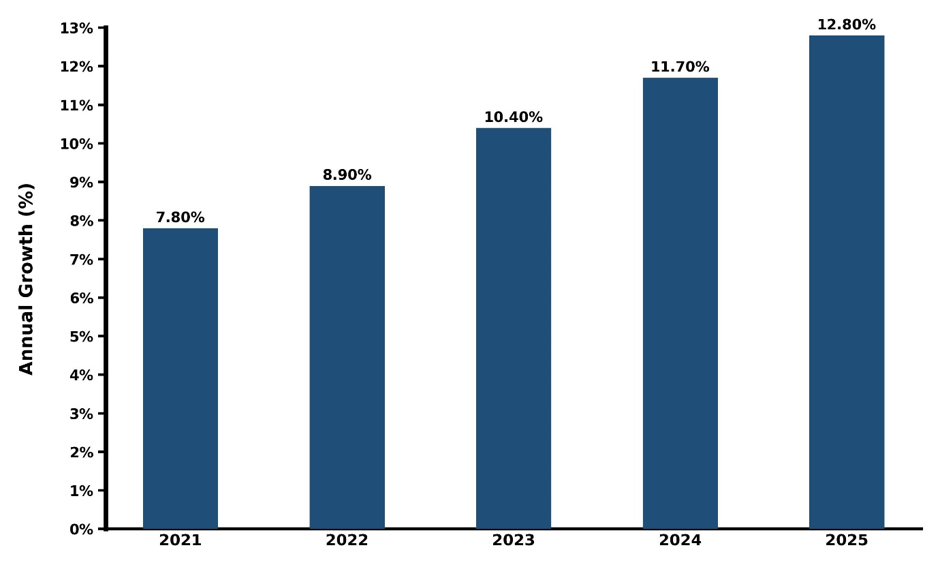
Below is an evaluation of year-wise growth rate along with growth drivers:
| Year | Est. Annual Growth (%) | Growth Drivers |
| 2021 | 7.8% | Early adoption of 3D mobile mapping for government urban planning and infrastructure projects |
| 2022 | 8.9% | Growth of investment by the private sector in survey and construction firms for precision mapping. |
| 2023 | 10.4% | Growing integration of LiDAR and UAV-based mapping technologies in commercial applications. |
| 2024 | 11.7% | Execution of smart city projects and GIS-based infrastructure development projects by municipal authorities. |
| 2025 | 12.8% | Growing adoption of AI-powered analytics, high-resolution mapping platforms, and cloud-based mobile mapping solutions |
Topics Covered in the Thailand 3D Mobile Mapping Market Report
The report covers the Thailand 3D Mobile Mapping Market by application, component, and end-user. It provides a detailed analysis of market trends, opportunities, and drivers, enabling stakeholders to align their strategies with current and emerging market dynamics.
Thailand 3D Mobile Mapping Market Highlights
| Report Name |
Thailand 3D Mobile Mapping Market |
| Forecast period | 2026-2032 |
| CAGR | 12.5% |
| Market Size |
Transportation & Logistics |
Thailand 3D Mobile Mapping Market Synopsis
Thailand 3D Mobile Mapping Market is estimated to grow in the forecast period due to some factors, which include the increasing implementation of LiDAR, GNSS, and photogrammetry technologies in mobile mapping, rising demand for reliable geospatial data, and growing applications in urban planning, construction, transportation, utilities, and environmental monitoring. Ability of 3D mobile mapping technology to collect real-time spatial data, generate digital twin maps, and produce accurate topographic and infrastructure maps has made this technology an integral part of many industries.
Evaluation of Growth Drivers in Thailand 3D Mobile Mapping Market (2026–2032)
Below are some major drivers and their influence on the market dynamics:
| Drivers | Primary Segment Affected | Why It Matters (Evidence) |
| Government Smart City Initiatives | Urban Planning, Infrastructure Development | National policies promoting smart city development drive investment in 3D mobile mapping technologies for city modeling, traffic management, and urban infrastructure planning. |
| Technological Advancements | LiDAR-based Mapping, UAVs, High-resolution Sensors | Adoption of advanced LiDAR, UAVs, and AI-powered geospatial software increases mapping accuracy and reduces survey time, boosting commercial adoption. |
| Rising Construction & Real Estate Projects | Surveying, Site Planning, Project Monitoring | There is a rising residential and industrial construction projects needs accurate 3D mapping for successful project execution. |
| High Adoption rate in Transportation & Logistics | Road Infrastructure, Railway Networks, Ports | Road Infrastructure, Railway Networks, Ports 3D mobile mapping helps to plan routes accurately and optimize logistics. |
| Cloud-based & Data Analytics Integration | GIS Platforms, Digital Twin Solutions | Integration with cloud-based analytics allows large-scale geospatial datasets to be processed efficiently, improving decision-making. |
The Thailand 3D Mobile Mapping Market growth is expected to reach a CAGR of around 12.5% during 2026–2032 owing to the rising number of smart city initiatives in Thailand, growing infrastructure spending, and the increasing use of AI and GIS-based analysis in mapping. Moreover, the growing requirements for automation in survey and mapping activities in industries like transport, urban planning, and environmental monitoring are driving adoption. Growing deployments of mobile mapping technologies in autonomous vehicles, railway networks, and construction monitoring activities are also contributing significantly to industry growth.
Evaluation of Restraints in Thailand 3D Mobile Mapping Market
Below are some major restraints and their influence on the market dynamics:
| Restraints | Primary Segment Affected | What This Means (Evidence) |
| High Initial Investment | LiDAR Equipment, UAV Systems | The cost of high-precision sensors, drones, and mobile mapping vehicles limits adoption among small and medium enterprises. |
| Skilled Workforce Shortage | Data Processing, GIS Analytics | Lack of trained personnel to interpret large geospatial datasets slows industry development. |
| Regulatory & Airspace Restrictions | UAV-based Mapping, Aerial Surveys | Strict rules for drone operations and data privacy create compliance challenges especially for mobile mapping service providers. |
| Limited Data Infrastructure | Cloud Storage, Real-time Data Access | Insufficient local cloud storage capacity delays the deployment of real-time mapping solutions. |
| Environmental & Weather Constraints | Outdoor Surveying, UAV Operations | Adverse weather conditions can disrupt field data collection, affecting operational efficiency. |
Challenges in the Thailand 3D Mobile Mapping Market
Challenges facing the Thailand 3D Mobile Mapping Market include the high initial investment required for advanced mobile mapping systems equipped with LiDAR and multi-sensor arrays. The complexity in integrating the map created by the mobile mapping system with the current GIS software could also present a challenge. Another environmental challenge could be a factor as dense urban areas, vegetated terrain, or harsh weather could reduce the accuracy of mapping. Data storage, processing, and management of geospatial data could also represent challenges for businesses.
Trends in the Thailand 3D Mobile Mapping Market
Some of the significant trends in the market are:
- IoT-enabled Mobility Systems: Utilization of 3D mobile mapping applications in self-driving cars and intelligent transport and logistics systems for better navigation.
- Smart Cities and Infrastructure Management: Incorporating 3D mapping technology in urban infrastructure projects, utilities monitoring, and construction projects for improving efficiency and accuracy.
- AI-Powered Geo-Spatial Data Analysis: Using artificial intelligence (AI) and machine learning (ML) technology for automatic feature extraction, digital twins, and prediction of environmental and infrastructure changes.
Investment Opportunities in the Thailand 3D Mobile Mapping Market
Below mentioned are some major investment opportunities in the market:
- Smart City and Urban Developments: Offering solutions for urban developments and infrastructure management through 3D mobile mapping services to governments.
- Transportation and Autonomous Vehicle Navigation: Offering road maps, railway maps, and autonomous vehicle navigation services to private enterprises and governments.
- Geographical Information System (GIS) Integration Solutions: Offering integrated solution platforms between geographical information system (GIS) and mobile mapping technology.
Top 5 Leading Players in Thailand 3D Mobile Mapping Market
Below is a list of prominent companies dominating the Thailand 3D Mobile Mapping Market Share:
1. Leica Geosystems
| Company Name | Leica Geosystems |
|---|---|
| Established Year | 2008 |
| Headquarters | Bangkok, Thailand |
| Official Website | Click Here |
Leica Geosystems delivers mobile LiDAR, GNSS, and 3D mapping solutions for surveying, urban planning, and infrastructure management.
2. Trimble
| Company Name | Trimble |
|---|---|
| Established Year | 2010 |
| Headquarters | Bangkok, Thailand |
| Official Website | Click Here |
Trimble provides advanced 3D mobile mapping systems, GNSS devices, and photogrammetry solutions for construction, transportation, and environmental monitoring applications.
3. Topcon
| Company Name | Topcon |
|---|---|
| Established Year | 2011 |
| Headquarters | Bangkok, Thailand |
| Official Website | Click Here |
Topcon supplies mobile LiDAR mapping platforms and GNSS-enabled 3D mapping solutions for urban planning, road construction, and surveying projects.
4. Riegl
| Company Name | Riegl |
|---|---|
| Established Year | 2013 |
| Headquarters | Bangkok, Thailand |
| Official Website | Click Here |
Riegl provides LiDAR scanners and mobile mapping solutions for geospatial surveys, infrastructure monitoring, and terrain modeling.
5. GeoMax
| Company Name | GeoMax |
|---|---|
| Established Year | 2012 |
| Headquarters | Bangkok, Thailand |
| Official Website | Click Here |
GeoMax delivers mobile mapping and GNSS solutions for surveying, GIS data collection, and environmental monitoring applications.
Government Initiatives Implemented in the Thailand 3D Mobile Mapping Market
According to Thai government data, these authorities are taking steps for the promotion of advanced technology such as geospatial and mapping technology by implementing initiatives such as the National Digital Economy and Society Plan (DES 2022-2027). This initative focuses on the implementation of GIS, LiDAR, and real-time mapping for various applications in urban planning, transportation, and disaster management. Another such initiative includes Geo-Informatics and Space Technology Development Agency (GISTDA), which helps in establishing a national geospatial data infrastructure.
Future Outlook of the Thailand 3D Mobile Mapping Market
The future of the Thailand 3D Mobile Mapping Market is expected to be quite optimistic owing to the growing use of autonomous navigation, smart city solutions, and geospatial analysis. The improvement in technology like LiDAR, GNSS, photogrammetry, and AI-based data processing may help in improving the mapping accuracy, speed, and efficiency. An increase in the use of digital twins and infrastructure monitoring will further boost market growth. Urban developments and the growing need for mapping in other sectors will help in the sustained growth of the market.
Market Segmentation Analysis
This report offers a comprehensive study of the following market segments and their leading categories:
By Component – Hardware to Dominate the Market
According to Ananya, Senior Research Analyst, 6Wresearch, by component, Hardware dominated with 42.3% share of the Thailand 3D Mobile Mapping Market in 2025, driven by the high adoption of LiDAR sensors, GNSS systems, and UAV-mounted mapping devices. Software solutions are projected to expand at a 15.2% CAGR during 2026–2032, fueled by rising demand for advanced mapping analytics, digital twin integration, and cloud-based geospatial platforms.
By Application – Road Surveys to Lead the Market
By application, Road Surveys dominated with 28.7% share in 2025, driven by urban infrastructure development, smart city initiatives, and transportation network planning. Topographic Mapping is projected to grow at a 14.8% CAGR during 2026–2032, supported by increasing demand for high-precision elevation data and 3D terrain modeling for construction and industrial projects.
Note: Market size and growth projections are calculated using 6Wresearch’s advanced research and forecasting methodology.
Key Attractiveness of the Report:
- 10 Years of Market Numbers
- Historical Data Starting from 2022 to 2025
- Base Year: 2025
- Forecast Data until 2032
- Key Performance Indicators Impacting the Market
- Major Upcoming Developments and Projects
Key Highlights of the Report:
- Thailand 3D Mobile Mapping Market Outlook
- Market Size of Thailand 3D Mobile Mapping Market, 2025
- Forecast of Thailand 3D Mobile Mapping Market, 2032
- Historical Data and Forecast of Thailand 3D Mobile Mapping Revenues & Volume for the Period 2022-2032
- Thailand 3D Mobile Mapping Market Trend Evolution
- Thailand 3D Mobile Mapping Market Drivers and Challenges
- Thailand 3D Mobile Mapping Price Trends
- Thailand 3D Mobile Mapping Porter's Five Forces
- Thailand 3D Mobile Mapping Industry Life Cycle
- Historical Data and Forecast of Thailand 3D Mobile Mapping Market Revenues & Volume By Component for the Period 2022-2032
- Historical Data and Forecast of Thailand 3D Mobile Mapping Market Revenues & Volume By Hardware for the Period 2022-2032
- Historical Data and Forecast of Thailand 3D Mobile Mapping Market Revenues & Volume By Software for the Period 2022-2032
- Historical Data and Forecast of Thailand 3D Mobile Mapping Market Revenues & Volume By Services for the Period 2022-2032
- Historical Data and Forecast of Thailand 3D Mobile Mapping Market Revenues & Volume By Application for the Period 2022-2032
- Historical Data and Forecast of Thailand 3D Mobile Mapping Market Revenues & Volume By Road Surveys for the Period 2022-2032
- Historical Data and Forecast of Thailand 3D Mobile Mapping Market Revenues & Volume By Topographic Mapping for the Period 2022-2032
- Historical Data and Forecast of Thailand 3D Mobile Mapping Market Revenues & Volume By 3D Modeling for the Period 2022-2032
- Historical Data and Forecast of Thailand 3D Mobile Mapping Market Revenues & Volume By Asset Management for the Period 2022-2032
- Historical Data and Forecast of Thailand 3D Mobile Mapping Market Revenues & Volume By Others for the Period 2021 - 2031
- Historical Data and Forecast of Thailand 3D Mobile Mapping Market Revenues & Volume By End User for the Period 2022-2032
- Historical Data and Forecast of Thailand 3D Mobile Mapping Market Revenues & Volume By Transportation & Logistics for the Period 2022-2032
- Historical Data and Forecast of Thailand 3D Mobile Mapping Market Revenues & Volume By Government & Public Sector for the Period 2022-2032
- Historical Data and Forecast of Thailand 3D Mobile Mapping Market Revenues & Volume By Energy & Utilities for the Period 2022-2032
- Historical Data and Forecast of Thailand 3D Mobile Mapping Market Revenues & Volume By Telecommunications for the Period 2022-2032
- Historical Data and Forecast of Thailand 3D Mobile Mapping Market Revenues & Volume By Others for the Period 2021 - 2031
- Thailand 3D Mobile Mapping Import Export Trade Statistics
- Market Opportunity Assessment By Component
- Market Opportunity Assessment By Application
- Market Opportunity Assessment By End User
- Thailand 3D Mobile Mapping Top Companies Market Share
- Thailand 3D Mobile Mapping Competitive Benchmarking By Technical and Operational Parameters
- Thailand 3D Mobile Mapping Company Profiles
- Thailand 3D Mobile Mapping Key Strategic Recommendations
Market Covered
The report offers an extensive study of the following market segments:
By Component
- Hardware
- Software
- Services
By Application
- Road Surveys
- Topographic Mapping
- 3D Modeling
- Asset Management
- Others
By End User
- Transportation & Logistics
- Government & Public Sector
- Energy & Utilities
- Telecommunications
- Others
Thailand 3D Mobile Mapping Market (2026-2032): FAQs
Thailand 3D Mobile Mapping Market is anticipated to grow at a compound annual growth rate (CAGR) of 12.5% during the forecast period (2026-2032).
Key drivers include increasing adoption of advanced LiDAR and UAV-based mapping solutions and rising demand for accurate geospatial data in transportation and industrial projects.
The LiDAR-based mapping and UAV technology segment dominates, supported by high adoption in urban planning, road network monitoring, and industrial surveying applications.
A key opportunity lies in the integration of cloud-based analytics and digital twin platforms, enabling real-time, large-scale 3D mapping for urban infrastructure.
6Wresearch actively monitors the Thailand 3D Mobile Mapping Market and publishes its comprehensive annual report, highlighting emerging trends, growth drivers, revenue analysis, and forecast outlook. Our insights help businesses to make data-backed strategic decisions with ongoing market dynamics. Our analysts track relevent industries related to the Thailand 3D Mobile Mapping Market, allowing our clients with actionable intelligence and reliable forecasts tailored to emerging regional needs.
Yes, we provide customisation as per your requirements. To learn more, feel free to contact us on sales@6wresearch.com
Global Go To Market Strategy - 2030
Export potential enables firms to identify high-growth global markets with greater confidence by combining advanced trade intelligence with a structured quantitative methodology. The framework analyzes emerging demand trends and country-level import patterns while integrating macroeconomic and trade datasets such as GDP and population forecasts, bilateral import–export flows, tariff structures, elasticity differentials between developed and developing economies, geographic distance, and import demand projections. Using weighted trade values from 2020–2024 as the base period to project country-to-country export potential for 2030, these inputs are operationalized through calculated drivers such as gravity model parameters, tariff impact factors, and projected GDP per-capita growth. Through an analysis of hidden potentials, demand hotspots, and market conditions that are most favorable to success, this method enables firms to focus on target countries, maximize returns, and global expansion with data, backed by accuracy.
By factoring in the projected importer demand gap that is currently unmet and could be potential opportunity, it identifies the potential for the Exporter (Country) among 190 countries, against the general trade analysis, which identifies the biggest importer or exporter.
To discover high-growth global markets and optimize your business strategy:
Click Here
Pricing
- Single User License$ 1,995
- Department License$ 2,400
- Site License$ 3,120
- Global License$ 3,795

Leadership Perspectives from Industry Events
Search
Thought Leadership and Analyst Meet


Our Clients
6WResearch In News
- Doha a strategic location for EV manufacturing hub: IPA Qatar
- Demand for luxury TVs surging in the GCC, says Samsung
- Empowering Growth: The Thriving Journey of Bangladesh’s Cable Industry
- Demand for luxury TVs surging in the GCC, says Samsung
- Video call with a traditional healer? Once unthinkable, it’s now common in South Africa
- Intelligent Buildings To Smooth GCC’s Path To Net Zero
Latest Reports
- Cape Verde Portable Hand-Thrown Extinguisher Market (2026-2032)
- Canada Portable Hand-Thrown Extinguisher Market (2026-2032)
- Cameroon Portable Hand-Thrown Extinguisher Market (2026-2032)
- Burundi Portable Hand-Thrown Extinguisher Market (2026-2032)
- Burkina Faso Portable Hand-Thrown Extinguisher Market (2026-2032)
- Bulgaria Portable Hand-Thrown Extinguisher Market (2026-2032)
- Brunei Portable Hand-Thrown Extinguisher Market (2026-2032)
- Botswana Portable Hand-Thrown Extinguisher Market (2026-2032)
- Bosnia and Herzegovina Portable Hand-Thrown Extinguisher Market (2026-2032)
- Bolivia Portable Hand-Thrown Extinguisher Market (2026-2032)
Industry Events and Analyst Meet

HIMTEX 2026

India Refining Summit 2026

India EV Show 2026

EV tech India Expo 2026

Auto Tech Asia 2026
Whitepaper
- Middle East & Africa Commercial Security Market Click here to view more.
- Middle East & Africa Fire Safety Systems & Equipment Market Click here to view more.
- GCC Drone Market Click here to view more.
- Middle East Lighting Fixture Market Click here to view more.
- GCC Physical & Perimeter Security Market Click here to view more.